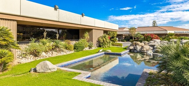
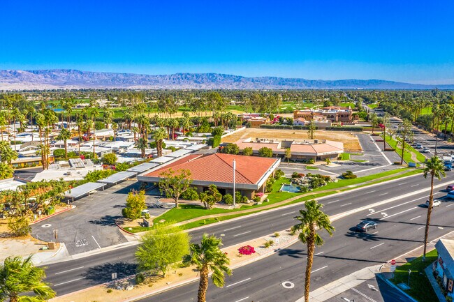
Property Record
70380 Highway 111, Rancho Mirage, CA 92270


NEARBY LISTINGS FOR SALE OR LEASE
Property Detail
70380 Highway 111
Riverside-San Bernardino-Ontario, CA
Parcel Map No 20973
689-210-027
.89 ACRES M/L IN POR PAR 4 AND PAR 1 PM 131/085 PM 20973
Officebuilding
Riverside
X
California
06065C1595G
1,4
2024
0.89 AC
2025
Coachella Valley
045103
Inland Empire (California)
6,742 SF
DEMOGRAPHICS near 70380 Highway 111
1 Mile
3 Mile
5 Mile
2024 Total Population
3,934
37,473
120,816
2029 Population
4,426
41,458
132,743
Pop Growth 2024-2029
+ 12.51%
+ 10.63%
+ 9.87%
Average Age
58
57
50
2024 Total Households
2,073
18,867
54,888
HH Growth 2024-2029
+ 12.30%
+ 10.42%
+ 10.15%
Median Household Inc
$85,108
$78,982
$68,924
Avg Household Size
1.80
1.90
2.10
2024 Avg HH Vehicles
2.00
2.00
2.00
Median Home Value
$624,350
$609,607
$558,707
Median Year Built
1981
1983
1985
Nearby Places
Map Layers
Map Styles
 Street
 Aerial
- Restaurants
- Banks
- Shops
- Fitness
- Groceries
PUBLIC TRANSPORTATION
AIRPORT
Palm Springs International
DRIVE
WALK
Distance
Palm Springs International
14 min
7.6 mi
SALE & LEASE HISTORY
LISTING DATE
SALE/LEASE

Sep 01, 2022
For Sale
May 23, 2018
For Lease
May 23, 2018
For Sale
May 17, 2021
For Sale
Jul 22, 2019
For Lease
Jan 30, 2019
For Sale
Dec 13, 2021
For Lease
Nearby Properties
Address
Land Use
TOTAL SIZE
Lot Size
Zoning
Address
Land Use
TOTAL SIZE
Lot Size
Zoning
370,095 SF
53.22 AC
Address
Land Use
TOTAL SIZE
Lot Size
Zoning
488,725 SF
24.17 AC
C1
Address
Land Use
TOTAL SIZE
Lot Size
Zoning
445,569 SF
17.55 AC
PUDC
Address
Land Use
TOTAL SIZE
Lot Size
Zoning
68.20 AC
Address
Land Use
TOTAL SIZE
Lot Size
Zoning
21,118 SF
162.93 AC
Address
Land Use
TOTAL SIZE
Lot Size
Zoning
217,730 SF
8.64 AC
R1010
Address
Land Use
TOTAL SIZE
Lot Size
Zoning
91,939 SF
8.80 AC
Address
Land Use
TOTAL SIZE
Lot Size
Zoning
186,531 SF
6 AC
Address
Land Use
TOTAL SIZE
Lot Size
Zoning
103,940 SF
4.56 AC
Address
Land Use
TOTAL SIZE
Lot Size
Zoning
179,685 SF
9.36 AC
Address
Land Use
TOTAL SIZE
Lot Size
Zoning
Address
Land Use
TOTAL SIZE
Lot Size
Zoning
137,962 SF
8.90 AC
Address
Land Use
TOTAL SIZE
Lot Size
Zoning
208,000 SF
16.04 AC
Address
Land Use
TOTAL SIZE
Lot Size
Zoning
136,875 SF
8.87 AC
O
Address
Land Use
TOTAL SIZE
Lot Size
Zoning
58,823 SF
5.87 AC
C-N
Address
Land Use
TOTAL SIZE
Lot Size
Zoning
44,823 SF
12.07 AC
CG
Address
Land Use
TOTAL SIZE
Lot Size
Zoning
Address
Land Use
TOTAL SIZE
Lot Size
Zoning
66,156 SF
5.85 AC
Address
Land Use
TOTAL SIZE
Lot Size
Zoning
36,514 SF
2.10 AC
PUDA
Address
Land Use
TOTAL SIZE
Lot Size
Zoning
92,722 SF
5.55 AC
O
Address
Land Use
TOTAL SIZE
Lot Size
Zoning
32,158 SF
1.96 AC
PUDLC
Address
Land Use
TOTAL SIZE
Lot Size
Zoning
66,732 SF
1.80 AC
PCC
Address
Land Use
TOTAL SIZE
Lot Size
Zoning
71,665 SF
3.31 AC
CN
Address
Land Use
TOTAL SIZE
Lot Size
Zoning
6,717 SF
17.79 AC
Address
Land Use
TOTAL SIZE
Lot Size
Zoning
78,310 SF
6.25 AC
PC3
Address
Land Use
TOTAL SIZE
Lot Size
Zoning
49,980 SF
4.29 AC
Address
Land Use
TOTAL SIZE
Lot Size
Zoning
5.15 AC
CG
Address
Land Use
TOTAL SIZE
Lot Size
Zoning
33,330 SF
4.50 AC
Address
Land Use
TOTAL SIZE
Lot Size
Zoning
32,333 SF
2.80 AC
C-N
The World's #1 Commercial Real Estate Marketplace
Connect with us
© 2026 CoStar Group
The information above has been obtained from sources believed reliable. While we do not doubt its accuracy we have not verified it and make no guarantee, warranty or representation about it. It is your responsibility to independently confirm its accuracy and completeness. Any projections, opinions, assumptions, or estimates used are for example only and do not represent the current or future performance of the property. The value of this transaction to you depends on tax and other factors which should be evaluated by your tax, financial, and legal advisors. You and your advisors should conduct a careful, independent investigation of the property to determine to your satisfaction the suitability of the property for your needs.