Property Record
704 Neal Rd, San Antonio, TX 78264

NEARBY LISTINGS FOR SALE OR LEASE
Property Detail
704 Neal Rd
San Antonio
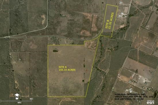
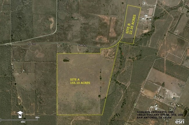
CB 4181 P-7 (128.57 AC) & CB 4180 P-12F (26.0 AC) ABS 465 (TRACT 4) 2022-NEW PER BCAD MERGE OR RESURVEY PER DEED 20210290475 (4 TRACTS CONVEYED) OUT OF VARIOUS PIDS. EXE 10-15-2021. VERIFY IMPTS. SEE SURVEY MAP ATTACHED
San Antonio-New Braunfels, TX
Bexar
04181-000-0073
Texas
Privatepreserveopenspacevacantlandforestlandconservation
7
2024
154.57 AC
2025
South
152100
DEMOGRAPHICS near 704 Neal Rd
1 Mile
3 Mile
5 Mile
2024 Total Population
75
2,937
17,509
2029 Population
78
3,101
19,064
Pop Growth 2024-2029
+ 4.00%
+ 5.58%
+ 8.88%
Average Age
39
38
35
2024 Total Households
24
911
5,356
HH Growth 2024-2029
+ 4.17%
+ 5.71%
+ 9.11%
Median Household Inc
$55,000
$53,851
$58,591
Avg Household Size
3.00
3.10
3.10
2024 Avg HH Vehicles
3.00
3.00
2.00
Median Home Value
$187,499
$166,190
$176,322
Median Year Built
1987
1991
2001
Nearby Places
Map Layers
Map Styles
 Street
 Aerial
- Restaurants
- Banks
- Shops
- Fitness
- Groceries
PUBLIC TRANSPORTATION
AIRPORT
San Antonio International
DRIVE
WALK
Distance
San Antonio International
37 min
24.7 mi
Freight Ports
Port of Corpus Christi
DRIVE
WALK
Distance
Port of Corpus Christi
143 min
135.3 mi
SALE & LEASE HISTORY
LISTING DATE
SALE/LEASE

Sep 05, 2017
For Sale
Jun 14, 2018
For Sale
Jul 19, 2018
For Sale
Nearby Properties
Address
Land Use
TOTAL SIZE
Lot Size
Zoning
Address
Land Use
TOTAL SIZE
Lot Size
Zoning
5,370,988 SF
1,995.73 AC
Address
Land Use
TOTAL SIZE
Lot Size
Zoning
850,200 SF
88.05 AC
Address
Land Use
TOTAL SIZE
Lot Size
Zoning
388,205 SF
9.74 AC
Address
Land Use
TOTAL SIZE
Lot Size
Zoning
96 SF
46.96 AC
Address
Land Use
TOTAL SIZE
Lot Size
Zoning
386,156 SF
10.50 AC
Address
Land Use
TOTAL SIZE
Lot Size
Zoning
348,707 SF
9.90 AC
Address
Land Use
TOTAL SIZE
Lot Size
Zoning
291,460 SF
9.48 AC
Address
Land Use
TOTAL SIZE
Lot Size
Zoning
329,893 SF
11.59 AC
Address
Land Use
TOTAL SIZE
Lot Size
Zoning
152,174 SF
Address
Land Use
TOTAL SIZE
Lot Size
Zoning
182,736 SF
16.49 AC
Address
Land Use
TOTAL SIZE
Lot Size
Zoning
170,679 SF
11.42 AC
Address
Land Use
TOTAL SIZE
Lot Size
Zoning
80,652 SF
11.77 AC
Address
Land Use
TOTAL SIZE
Lot Size
Zoning
80,640 SF
6 AC
Address
Land Use
TOTAL SIZE
Lot Size
Zoning
99,350 SF
2.44 AC
Address
Land Use
TOTAL SIZE
Lot Size
Zoning
69,575 SF
7.72 AC
Address
Land Use
TOTAL SIZE
Lot Size
Zoning
70,255 SF
3.02 AC
Address
Land Use
TOTAL SIZE
Lot Size
Zoning
235,275 SF
2.92 AC
Address
Land Use
TOTAL SIZE
Lot Size
Zoning
79,000 SF
5.91 AC
Address
Land Use
TOTAL SIZE
Lot Size
Zoning
109,195 SF
5.47 AC
Address
Land Use
TOTAL SIZE
Lot Size
Zoning
65,567 SF
3.04 AC
Address
Land Use
TOTAL SIZE
Lot Size
Zoning
1,124 SF
414.76 AC
Address
Land Use
TOTAL SIZE
Lot Size
Zoning
58,225 SF
12.11 AC
Address
Land Use
TOTAL SIZE
Lot Size
Zoning
155.69 AC
Address
Land Use
TOTAL SIZE
Lot Size
Zoning
185.94 AC
Address
Land Use
TOTAL SIZE
Lot Size
Zoning
42,400 SF
2.92 AC
Address
Land Use
TOTAL SIZE
Lot Size
Zoning
43,620 SF
4.33 AC
Address
Land Use
TOTAL SIZE
Lot Size
Zoning
84.42 AC
Address
Land Use
TOTAL SIZE
Lot Size
Zoning
221.72 AC
Address
Land Use
TOTAL SIZE
Lot Size
Zoning
184.42 AC
Address
Land Use
TOTAL SIZE
Lot Size
Zoning
157.08 AC
The World's #1 Commercial Real Estate Marketplace
Connect with us
© 2026 CoStar Group
The information above has been obtained from sources believed reliable. While we do not doubt its accuracy we have not verified it and make no guarantee, warranty or representation about it. It is your responsibility to independently confirm its accuracy and completeness. Any projections, opinions, assumptions, or estimates used are for example only and do not represent the current or future performance of the property. The value of this transaction to you depends on tax and other factors which should be evaluated by your tax, financial, and legal advisors. You and your advisors should conduct a careful, independent investigation of the property to determine to your satisfaction the suitability of the property for your needs.