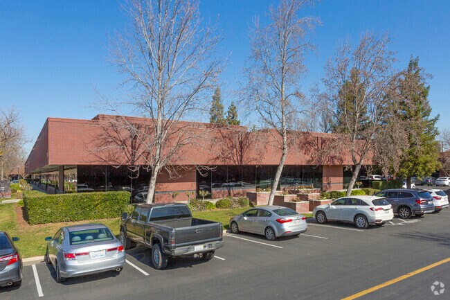
Property Record
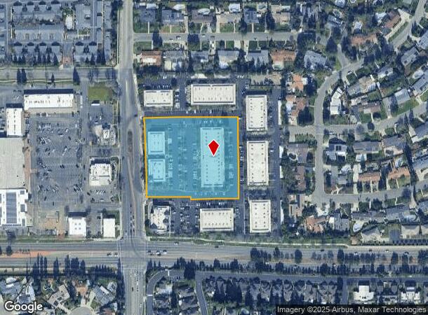
7040 N Marks Ave, Fresno, CA 93711


Current Lease Availabilities
NEARBY LISTINGS FOR SALE OR LEASE
Property Detail
7040 N Marks Ave
500-211-29
3.43 AC PARCEL K P/M 90-20 BK 52 PGS 81-83
Officebuilding
Fresno
X
California
06019C1555H
3.43 AC
2025
North Fresno
2025
Fresno
004301
Fresno, CA
36,852 SF
DEMOGRAPHICS near 7040 N Marks Ave
1 Mile
3 Mile
5 Mile
2024 Total Population
9,293
91,849
241,198
2029 Population
9,466
93,874
246,366
Pop Growth 2024-2029
+ 1.86%
+ 2.20%
+ 2.14%
Average Age
48
39
37
2024 Total Households
3,820
34,543
84,734
HH Growth 2024-2029
+ 1.83%
+ 2.21%
+ 2.12%
Median Household Inc
$111,982
$75,010
$69,445
Avg Household Size
2.40
2.60
2.80
2024 Avg HH Vehicles
2.00
2.00
2.00
Median Home Value
$491,852
$377,527
$344,279
Median Year Built
1983
1984
1980
Nearby Places
Map Layers
Map Styles
 Street
 Aerial
- Restaurants
- Banks
- Shops
- Fitness
- Groceries
PUBLIC TRANSPORTATION
AIRPORT
Fresno Yosemite International
DRIVE
WALK
Distance
Fresno Yosemite International
20 min
11.9 mi
Freight Ports
Port of Stockton
DRIVE
WALK
Distance
Port of Stockton
145 min
121.4 mi
Nearby Properties
Address
Land Use
TOTAL SIZE
Lot Size
Zoning
Address
Land Use
TOTAL SIZE
Lot Size
Zoning
39,888 SF
23.72 AC
C3
Address
Land Use
TOTAL SIZE
Lot Size
Zoning
477,820 SF
18.78 AC
RA
Address
Land Use
TOTAL SIZE
Lot Size
Zoning
412,974 SF
29.02 AC
R2
Address
Land Use
TOTAL SIZE
Lot Size
Zoning
197,659 SF
11.80 AC
CC
Address
Land Use
TOTAL SIZE
Lot Size
Zoning
423,568 SF
32.25 AC
R2
Address
Land Use
TOTAL SIZE
Lot Size
Zoning
328,887 SF
16.34 AC
R3
Address
Land Use
TOTAL SIZE
Lot Size
Zoning
234,370 SF
23 AC
SPLIT
Address
Land Use
TOTAL SIZE
Lot Size
Zoning
278,502 SF
19.42 AC
SPLIT
Address
Land Use
TOTAL SIZE
Lot Size
Zoning
251,904 SF
16.70 AC
SPLIT
Address
Land Use
TOTAL SIZE
Lot Size
Zoning
178,900 SF
11.68 AC
CP
Address
Land Use
TOTAL SIZE
Lot Size
Zoning
54,758 SF
8 AC
AE5
Address
Land Use
TOTAL SIZE
Lot Size
Zoning
126,346 SF
5.49 AC
CP
Address
Land Use
TOTAL SIZE
Lot Size
Zoning
126,346 SF
5.31 AC
CP
Address
Land Use
TOTAL SIZE
Lot Size
Zoning
218,838 SF
19.06 AC
R2
Address
Land Use
TOTAL SIZE
Lot Size
Zoning
176,228 SF
10.17 AC
R2
Address
Land Use
TOTAL SIZE
Lot Size
Zoning
150,437 SF
14.72 AC
SPLIT
Address
Land Use
TOTAL SIZE
Lot Size
Zoning
70,678 SF
4.23 AC
Address
Land Use
TOTAL SIZE
Lot Size
Zoning
56,331 SF
5.31 AC
CM
Address
Land Use
TOTAL SIZE
Lot Size
Zoning
83,026 SF
5.02 AC
RM1
Address
Land Use
TOTAL SIZE
Lot Size
Zoning
124,055 SF
9.35 AC
R2
Address
Land Use
TOTAL SIZE
Lot Size
Zoning
92,279 SF
0.01 AC
CM
Address
Land Use
TOTAL SIZE
Lot Size
Zoning
42,166 SF
1.63 AC
CM
Address
Land Use
TOTAL SIZE
Lot Size
Zoning
124,828 SF
5.70 AC
C2
Address
Land Use
TOTAL SIZE
Lot Size
Zoning
46,938 SF
9.25 AC
C6
Address
Land Use
TOTAL SIZE
Lot Size
Zoning
45,226 SF
2.77 AC
C2
Address
Land Use
TOTAL SIZE
Lot Size
Zoning
210,336 SF
11.97 AC
CP
Address
Land Use
TOTAL SIZE
Lot Size
Zoning
88,859 SF
2.44 AC
CP
Address
Land Use
TOTAL SIZE
Lot Size
Zoning
43,944 SF
3.21 AC
CM
Address
Land Use
TOTAL SIZE
Lot Size
Zoning
38,016 SF
3.18 AC
CM
Address
Land Use
TOTAL SIZE
Lot Size
Zoning
45,944 SF
2.30 AC
CP
The World's #1 Commercial Real Estate Marketplace
Connect with us
© 2025 CoStar Group
The information above has been obtained from sources believed reliable. While we do not doubt its accuracy we have not verified it and make no guarantee, warranty or representation about it. It is your responsibility to independently confirm its accuracy and completeness. Any projections, opinions, assumptions, or estimates used are for example only and do not represent the current or future performance of the property. The value of this transaction to you depends on tax and other factors which should be evaluated by your tax, financial, and legal advisors. You and your advisors should conduct a careful, independent investigation of the property to determine to your satisfaction the suitability of the property for your needs.