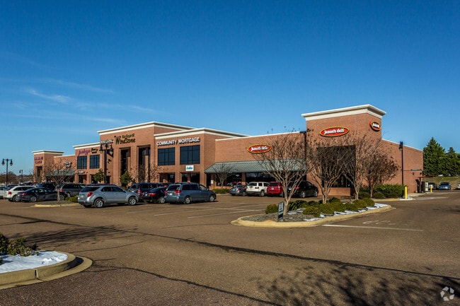
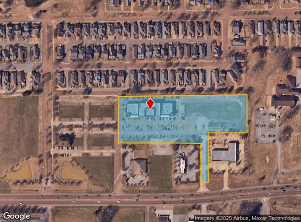
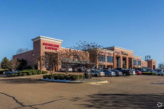
Property Record
7040 Wind Stone Blvd, Olive Branch, MS 38654
NEARBY LISTINGS FOR SALE OR LEASE
Property Detail
7040 Wind Stone Blvd
Memphis, TN-MS-AR
Windstone Commercial Lot 2
1077261500000200
WINDSTONE COMMERCIAL LOT 2
Realpropertynec
DeSoto
X
Mississippi
47157C0585F
2
2025
5.89 AC
2025
Olive Branch
070524
Memphis
33,194 SF
DEMOGRAPHICS near 7040 Wind Stone Blvd
1 Mile
3 Mile
5 Mile
2024 Total Population
3,798
25,072
75,749
2029 Population
4,162
27,566
81,521
Pop Growth 2024-2029
+ 9.58%
+ 9.95%
+ 7.62%
Average Age
42
41
39
2024 Total Households
1,390
8,985
27,320
HH Growth 2024-2029
+ 9.57%
+ 9.92%
+ 7.63%
Median Household Inc
$94,006
$88,863
$80,474
Avg Household Size
2.70
2.70
2.70
2024 Avg HH Vehicles
2.00
2.00
2.00
Median Home Value
$283,308
$264,953
$240,619
Median Year Built
2003
2002
1997
Nearby Places
Map Layers
Map Styles
 Street
 Aerial
- Restaurants
- Banks
- Shops
- Fitness
- Groceries
PUBLIC TRANSPORTATION
AIRPORT
Memphis International
DRIVE
WALK
Distance
Memphis International
19 min
11.2 mi
Freight Ports
Port of Shreveport
DRIVE
WALK
Distance
Port of Shreveport
423 min
387.0 mi
Nearby Properties
Address
Land Use
TOTAL SIZE
Lot Size
Zoning
Address
Land Use
TOTAL SIZE
Lot Size
Zoning
897,076 SF
47.33 AC
CA
Address
Land Use
TOTAL SIZE
Lot Size
Zoning
921,576 SF
25.20 AC
CA
Address
Land Use
TOTAL SIZE
Lot Size
Zoning
865,065 SF
51.05 AC
CA
Address
Land Use
TOTAL SIZE
Lot Size
Zoning
3,437 SF
169.11 AC
CA
Address
Land Use
TOTAL SIZE
Lot Size
Zoning
366,046 SF
22.37 AC
CA
Address
Land Use
TOTAL SIZE
Lot Size
Zoning
316,573 SF
30.77 AC
CA
Address
Land Use
TOTAL SIZE
Lot Size
Zoning
814,054 SF
51.14 AC
M-1
Address
Land Use
TOTAL SIZE
Lot Size
Zoning
60,296 SF
18.86 AC
CA
Address
Land Use
TOTAL SIZE
Lot Size
Zoning
180,307 SF
9.97 AC
CA
Address
Land Use
TOTAL SIZE
Lot Size
Zoning
368,608 SF
21.85 AC
M-1
Address
Land Use
TOTAL SIZE
Lot Size
Zoning
5,189 SF
9.62 AC
C-4
Address
Land Use
TOTAL SIZE
Lot Size
Zoning
5,384 SF
7.92 AC
PUD
Address
Land Use
TOTAL SIZE
Lot Size
Zoning
64,571 SF
11.09 AC
C-4
Address
Land Use
TOTAL SIZE
Lot Size
Zoning
30,223 SF
12.41 AC
C-4
Address
Land Use
TOTAL SIZE
Lot Size
Zoning
127,150 SF
11.17 AC
C-4
Address
Land Use
TOTAL SIZE
Lot Size
Zoning
83,020 SF
13.19 AC
C-4
Address
Land Use
TOTAL SIZE
Lot Size
Zoning
75,682 SF
44.88 AC
CA
Address
Land Use
TOTAL SIZE
Lot Size
Zoning
1,125 SF
13.69 AC
EMP
Address
Land Use
TOTAL SIZE
Lot Size
Zoning
101,248 SF
9.47 AC
C-4
Address
Land Use
TOTAL SIZE
Lot Size
Zoning
104,717 SF
15.81 AC
C-4
Address
Land Use
TOTAL SIZE
Lot Size
Zoning
19,576 SF
2.65 AC
PUD
Address
Land Use
TOTAL SIZE
Lot Size
Zoning
181,300 SF
12.50 AC
M-1
Address
Land Use
TOTAL SIZE
Lot Size
Zoning
128,412 SF
8.08 AC
M-1
Address
Land Use
TOTAL SIZE
Lot Size
Zoning
34,542 SF
8.41 AC
C-4
Address
Land Use
TOTAL SIZE
Lot Size
Zoning
95.44 AC
CA
Address
Land Use
TOTAL SIZE
Lot Size
Zoning
59,864 SF
6.10 AC
R-3
Address
Land Use
TOTAL SIZE
Lot Size
Zoning
9,150 SF
5.73 AC
EMP
Address
Land Use
TOTAL SIZE
Lot Size
Zoning
61,948 SF
4.37 AC
PUD
Address
Land Use
TOTAL SIZE
Lot Size
Zoning
40,287 SF
10.74 AC
C-4
Address
Land Use
TOTAL SIZE
Lot Size
Zoning
20,550 SF
6.13 AC
IH
The World's #1 Commercial Real Estate Marketplace
Connect with us
© 2026 CoStar Group
The information above has been obtained from sources believed reliable. While we do not doubt its accuracy we have not verified it and make no guarantee, warranty or representation about it. It is your responsibility to independently confirm its accuracy and completeness. Any projections, opinions, assumptions, or estimates used are for example only and do not represent the current or future performance of the property. The value of this transaction to you depends on tax and other factors which should be evaluated by your tax, financial, and legal advisors. You and your advisors should conduct a careful, independent investigation of the property to determine to your satisfaction the suitability of the property for your needs.