Property Record
7027 State Route 800 Se, Uhrichsville, OH 44683
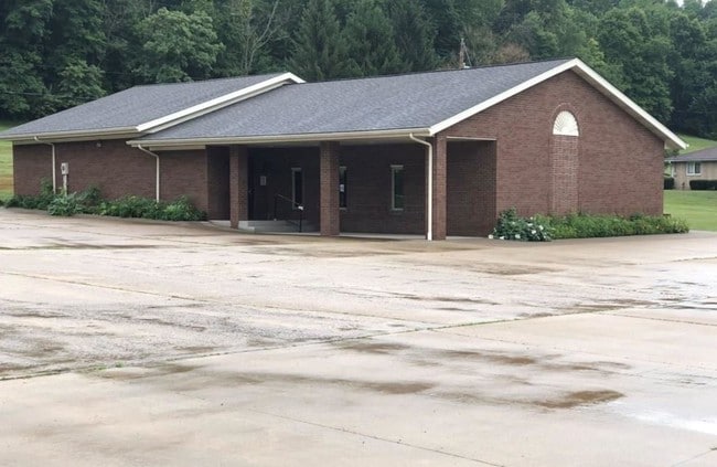


This Property Is For Sale
NEARBY LISTINGS FOR SALE OR LEASE
-
-
View all Uhrichsville listings for sale on LoopNet.com
Property Detail
7027 State Route 800 Se
New Philadelphia-Dover, OH
Tuscarawas
3901706000
Ohio
Sfr
0.97 AC
X
Ohio North Area
39157C0295D
Other Market Areas
448 SF
DEMOGRAPHICS near 7027 State Route 800 Se
1 Mile
3 Mile
5 Mile
2024 Total Population
216
8,793
12,435
2029 Population
213
8,801
12,383
Pop Growth 2024-2029
(1.39%)
+ 0.09%
(0.42%)
Average Age
38
39
40
2024 Total Households
84
3,446
4,996
HH Growth 2024-2029
(1.19%)
(0.06%)
(0.58%)
Median Household Inc
$52,916
$53,867
$50,288
Avg Household Size
2.40
2.50
2.40
2024 Avg HH Vehicles
2.00
2.00
2.00
Median Home Value
$102,381
$81,572
$84,952
Median Year Built
1965
1952
1960
Nearby Places
Map Layers
Map Styles
 Street
 Aerial
- Restaurants
- Banks
- Shops
- Fitness
- Groceries
Nearby Properties
Address
Land Use
TOTAL SIZE
Lot Size
Zoning
Address
Land Use
TOTAL SIZE
Lot Size
Zoning
53,801 SF
10.76 AC
Address
Land Use
TOTAL SIZE
Lot Size
Zoning
1,032 SF
30.60 AC
Address
Land Use
TOTAL SIZE
Lot Size
Zoning
3,284 SF
1.64 AC
Address
Land Use
TOTAL SIZE
Lot Size
Zoning
3,870 SF
201.73 AC
Address
Land Use
TOTAL SIZE
Lot Size
Zoning
12,856 SF
3.55 AC
Address
Land Use
TOTAL SIZE
Lot Size
Zoning
12.70 AC
Address
Land Use
TOTAL SIZE
Lot Size
Zoning
10.50 AC
Address
Land Use
TOTAL SIZE
Lot Size
Zoning
9,792 SF
0.50 AC
Address
Land Use
TOTAL SIZE
Lot Size
Zoning
8,444 SF
3.30 AC
Address
Land Use
TOTAL SIZE
Lot Size
Zoning
6,676 SF
5.98 AC
Address
Land Use
TOTAL SIZE
Lot Size
Zoning
29,976 SF
2.32 AC
Address
Land Use
TOTAL SIZE
Lot Size
Zoning
174.97 AC
Address
Land Use
TOTAL SIZE
Lot Size
Zoning
5,644 SF
12.34 AC
Address
Land Use
TOTAL SIZE
Lot Size
Zoning
5,376 SF
0.34 AC
Address
Land Use
TOTAL SIZE
Lot Size
Zoning
Address
Land Use
TOTAL SIZE
Lot Size
Zoning
3,400 SF
141.41 AC
Address
Land Use
TOTAL SIZE
Lot Size
Zoning
6,542 SF
93.99 AC
Address
Land Use
TOTAL SIZE
Lot Size
Zoning
2,994 SF
125.10 AC
Address
Land Use
TOTAL SIZE
Lot Size
Zoning
4,586 SF
58.39 AC
Address
Land Use
TOTAL SIZE
Lot Size
Zoning
5,864 SF
30 AC
Address
Land Use
TOTAL SIZE
Lot Size
Zoning
5,840 SF
11.72 AC
Address
Land Use
TOTAL SIZE
Lot Size
Zoning
5,462 SF
15.94 AC
Address
Land Use
TOTAL SIZE
Lot Size
Zoning
4,110 SF
26.60 AC
Address
Land Use
TOTAL SIZE
Lot Size
Zoning
3,204 SF
81.02 AC
Address
Land Use
TOTAL SIZE
Lot Size
Zoning
4,318 SF
54.90 AC
Address
Land Use
TOTAL SIZE
Lot Size
Zoning
2,670 SF
113 AC
Address
Land Use
TOTAL SIZE
Lot Size
Zoning
5,354 SF
18.56 AC
Address
Land Use
TOTAL SIZE
Lot Size
Zoning
3,824 SF
46 AC
Address
Land Use
TOTAL SIZE
Lot Size
Zoning
3,936 SF
39.77 AC
Address
Land Use
TOTAL SIZE
Lot Size
Zoning
The World's #1 Commercial Real Estate Marketplace
Connect with us
© 2026 CoStar Group
The information above has been obtained from sources believed reliable. While we do not doubt its accuracy we have not verified it and make no guarantee, warranty or representation about it. It is your responsibility to independently confirm its accuracy and completeness. Any projections, opinions, assumptions, or estimates used are for example only and do not represent the current or future performance of the property. The value of this transaction to you depends on tax and other factors which should be evaluated by your tax, financial, and legal advisors. You and your advisors should conduct a careful, independent investigation of the property to determine to your satisfaction the suitability of the property for your needs.