Property Record
7044 Bennett Valley Rd, Santa Rosa, CA 95404
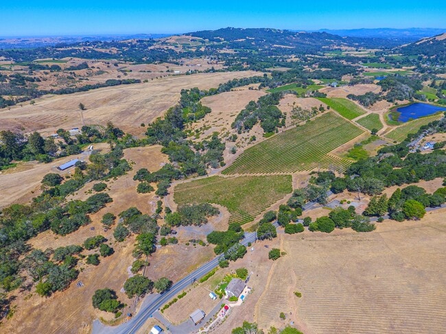


This Property Is For Sale
Property Detail
7044 Bennett Valley Rd
Santa Rosa-Petaluma, CA
88 FM 55-010-28 PT TO 31 PM 86-044
055-010-030
SONOMA
Vineyard
California
LIA40
1
B and X Area of moderate flood hazard, usually the area between the limits of the 100-year and 500-year floods.
60.03 AC
2025
Santa Rosa
2025
North Bay/Santa Rosa
150501
NEARBY LISTINGS FOR SALE OR LEASE
-
-
View all Santa Rosa listings for sale on LoopNet.com
DEMOGRAPHICS near 7044 Bennett Valley Rd
1 mile
3 mile
5 mile
2025 Total Population
224
2,466
33,500
2030 Population
215
2,367
33,304
Pop Growth 2025-2030
(4.02%)
(4.01%)
(0.59%)
Average Age
54
59
48
2025 Total Households
97
1,186
13,542
HH Growth 2025-2030
(3.09%)
(3.46%)
(0.67%)
Median Household Inc
$220,370
$142,666
$118,832
Avg Household Size
2.30
2.10
2.20
2025 Avg HH Vehicles
3.00
2.00
2.00
Median Home Value
$1,097,619
$1,055,328
$818,702
Median Year Built
1980
1980
1978
Nearby Places
Map Layers
Map Styles
 Street
 Aerial
Layers
 Traffic
 Biking
Places
Listings with unknown addresses are not visible on the map
- Restaurants
- Banks
- Shops
- Fitness
- Groceries
PUBLIC TRANSPORTATION
COMMUTER RAIL
Drive
Walk
Distance
20 min
8.7 mi
Drive
Walk
Distance
21 min
9.2 mi
AIRPORT
Charles M Schulz - Sonoma County
Drive
Walk
Distance
Charles M Schulz - Sonoma County
31 min
16.5 mi
Freight Ports
Port of Richmond
Drive
Walk
Distance
Port of Richmond
74 min
48.2 mi
Nearby Properties
Address
Land Use
TOTAL SIZE
Lot Size
Zoning
Address
Land Use
TOTAL SIZE
Lot Size
Zoning
978 SF
150.82 AC
Address
Land Use
TOTAL SIZE
Lot Size
Zoning
3,991 SF
46.67 AC
Address
Land Use
TOTAL SIZE
Lot Size
Zoning
2,021 SF
40.50 AC
DA10
Address
Land Use
TOTAL SIZE
Lot Size
Zoning
5,866 SF
12.69 AC
DA20
Address
Land Use
TOTAL SIZE
Lot Size
Zoning
8,239 SF
5.13 AC
A1
Address
Land Use
TOTAL SIZE
Lot Size
Zoning
898 SF
47 AC
Address
Land Use
TOTAL SIZE
Lot Size
Zoning
6,787 SF
24.95 AC
DA15
Address
Land Use
TOTAL SIZE
Lot Size
Zoning
5,542 SF
10.17 AC
DA20
Address
Land Use
TOTAL SIZE
Lot Size
Zoning
7,974 SF
93.07 AC
LIA60
Address
Land Use
TOTAL SIZE
Lot Size
Zoning
394.18 AC
Address
Land Use
TOTAL SIZE
Lot Size
Zoning
2,994 SF
89.10 AC
DA19
Address
Land Use
TOTAL SIZE
Lot Size
Zoning
3,865 SF
5.02 AC
Address
Land Use
TOTAL SIZE
Lot Size
Zoning
4,193 SF
18.61 AC
DA10
Address
Land Use
TOTAL SIZE
Lot Size
Zoning
634 SF
21.47 AC
Address
Land Use
TOTAL SIZE
Lot Size
Zoning
4,214 SF
39.50 AC
Address
Land Use
TOTAL SIZE
Lot Size
Zoning
4,361 SF
10.38 AC
DA20
Address
Land Use
TOTAL SIZE
Lot Size
Zoning
1,853 SF
80 AC
Address
Land Use
TOTAL SIZE
Lot Size
Zoning
400 SF
56.93 AC
DA15
Address
Land Use
TOTAL SIZE
Lot Size
Zoning
2,795 SF
65.97 AC
Address
Land Use
TOTAL SIZE
Lot Size
Zoning
4,728 SF
10 AC
DA20
Address
Land Use
TOTAL SIZE
Lot Size
Zoning
2,516 SF
40.76 AC
DA15
Address
Land Use
TOTAL SIZE
Lot Size
Zoning
3,358 SF
73.90 AC
RR8
Address
Land Use
TOTAL SIZE
Lot Size
Zoning
2,682 SF
40.01 AC
Address
Land Use
TOTAL SIZE
Lot Size
Zoning
5,558 SF
10.36 AC
Address
Land Use
TOTAL SIZE
Lot Size
Zoning
2,850 SF
22.15 AC
DA20
Address
Land Use
TOTAL SIZE
Lot Size
Zoning
3,733 SF
6.14 AC
Address
Land Use
TOTAL SIZE
Lot Size
Zoning
6,345 SF
44.10 AC
Address
Land Use
TOTAL SIZE
Lot Size
Zoning
1,240 SF
9.34 AC
DA10
Address
Land Use
TOTAL SIZE
Lot Size
Zoning
1,935 SF
82.97 AC
Address
Land Use
TOTAL SIZE
Lot Size
Zoning
3,345 SF
29.70 AC
The World's #1 Commercial Real Estate Marketplace
Connect with us
© 2026 CoStar Group
The information above has been obtained from sources believed reliable. While we do not doubt its accuracy we have not verified it and make no guarantee, warranty or representation about it. It is your responsibility to independently confirm its accuracy and completeness. Any projections, opinions, assumptions, or estimates used are for example only and do not represent the current or future performance of the property. The value of this transaction to you depends on tax and other factors which should be evaluated by your tax, financial, and legal advisors. You and your advisors should conduct a careful, independent investigation of the property to determine to your satisfaction the suitability of the property for your needs.