No Photo
Property Record
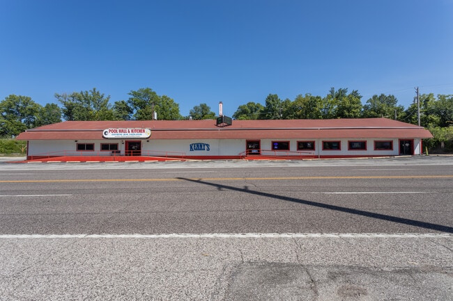
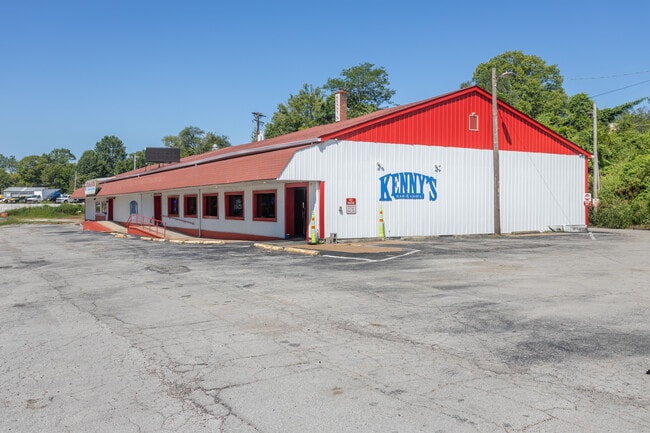
7045 Us Highway 61-67, Barnhart, MO 63012
NEARBY LISTINGS FOR SALE OR LEASE
-
-
View all Barnhart listings for sale on LoopNet.com
Property Detail
7045 Us Highway 61-67
St. Louis, MO-IL
Us Survey 747
09-9.0-30.0-4-003-001
US SURVEY 747 PT LOT 4
Storebuilding
Jefferson
AE
Missouri
29099C0234F
4
2024
1.23 AC
2025
Jefferson County
700603
St. Louis
10,204 SF
DEMOGRAPHICS near 7045 Us Highway 61-67
1 Mile
3 Mile
5 Mile
2024 Total Population
2,722
16,436
44,451
2029 Population
2,815
16,896
45,306
Pop Growth 2024-2029
+ 3.42%
+ 2.80%
+ 1.92%
Average Age
40
40
39
2024 Total Households
976
5,963
16,485
HH Growth 2024-2029
+ 3.69%
+ 3.04%
+ 2.08%
Median Household Inc
$91,095
$86,909
$78,887
Avg Household Size
2.70
2.70
2.70
2024 Avg HH Vehicles
2.00
2.00
2.00
Median Home Value
$205,039
$237,164
$221,949
Median Year Built
1983
1989
1990
Nearby Places
Map Layers
Map Styles
 Street
 Aerial
- Restaurants
- Banks
- Shops
- Fitness
- Groceries
PUBLIC TRANSPORTATION
AIRPORT
St Louis Lambert International
DRIVE
WALK
Distance
St Louis Lambert International
49 min
33.9 mi
Freight Ports
Tulsa Port of Inola
DRIVE
WALK
Distance
Tulsa Port of Inola
421 min
371.9 mi
SALE & LEASE HISTORY
LISTING DATE
SALE/LEASE

Aug 16, 2024
For Sale
Nearby Properties
Address
Land Use
TOTAL SIZE
Lot Size
Zoning
Address
Land Use
TOTAL SIZE
Lot Size
Zoning
67,628 SF
9.17 AC
CC2
Address
Land Use
TOTAL SIZE
Lot Size
Zoning
15.10 AC
CC2
Address
Land Use
TOTAL SIZE
Lot Size
Zoning
33,734 SF
5.61 AC
CC2
Address
Land Use
TOTAL SIZE
Lot Size
Zoning
51,103 SF
10.83 AC
CC2
Address
Land Use
TOTAL SIZE
Lot Size
Zoning
11,113 SF
1.03 AC
CC2
Address
Land Use
TOTAL SIZE
Lot Size
Zoning
81,590 SF
5.36 AC
CC2
Address
Land Use
TOTAL SIZE
Lot Size
Zoning
33,802 SF
5.07 AC
CC2
Address
Land Use
TOTAL SIZE
Lot Size
Zoning
69,807 SF
5.38 AC
CC2
Address
Land Use
TOTAL SIZE
Lot Size
Zoning
7,395 SF
4.75 AC
CC2
Address
Land Use
TOTAL SIZE
Lot Size
Zoning
15,035 SF
2.06 AC
CC2
Address
Land Use
TOTAL SIZE
Lot Size
Zoning
77,283 SF
111.18 AC
Address
Land Use
TOTAL SIZE
Lot Size
Zoning
64,760 SF
5.91 AC
CC2
Address
Land Use
TOTAL SIZE
Lot Size
Zoning
8,365 SF
2.05 AC
Address
Land Use
TOTAL SIZE
Lot Size
Zoning
10,820 SF
1.37 AC
CC2
Address
Land Use
TOTAL SIZE
Lot Size
Zoning
5,274 SF
1.54 AC
CC2
Address
Land Use
TOTAL SIZE
Lot Size
Zoning
5,828 SF
0.94 AC
CC2
Address
Land Use
TOTAL SIZE
Lot Size
Zoning
76,210 SF
23.97 AC
R20
Address
Land Use
TOTAL SIZE
Lot Size
Zoning
8,152 SF
1.97 AC
CC2
Address
Land Use
TOTAL SIZE
Lot Size
Zoning
5,160 SF
1.04 AC
CC2
Address
Land Use
TOTAL SIZE
Lot Size
Zoning
5,606 SF
1.45 AC
CC2
Address
Land Use
TOTAL SIZE
Lot Size
Zoning
60,100 SF
5.42 AC
PI
Address
Land Use
TOTAL SIZE
Lot Size
Zoning
5,228 SF
2 AC
Address
Land Use
TOTAL SIZE
Lot Size
Zoning
15,393 SF
94.18 AC
R40
Address
Land Use
TOTAL SIZE
Lot Size
Zoning
30,693 SF
4.16 AC
CC2
Address
Land Use
TOTAL SIZE
Lot Size
Zoning
16,875 SF
2.56 AC
CC2
Address
Land Use
TOTAL SIZE
Lot Size
Zoning
23,400 SF
36 AC
CC2
Address
Land Use
TOTAL SIZE
Lot Size
Zoning
37,650 SF
5.10 AC
CC2
Address
Land Use
TOTAL SIZE
Lot Size
Zoning
17,120 SF
8.29 AC
R40
Address
Land Use
TOTAL SIZE
Lot Size
Zoning
13,970 SF
11.55 AC
CC2
The World's #1 Commercial Real Estate Marketplace
Connect with us
© 2025 CoStar Group
The information above has been obtained from sources believed reliable. While we do not doubt its accuracy we have not verified it and make no guarantee, warranty or representation about it. It is your responsibility to independently confirm its accuracy and completeness. Any projections, opinions, assumptions, or estimates used are for example only and do not represent the current or future performance of the property. The value of this transaction to you depends on tax and other factors which should be evaluated by your tax, financial, and legal advisors. You and your advisors should conduct a careful, independent investigation of the property to determine to your satisfaction the suitability of the property for your needs.