Property Record
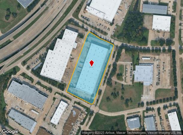
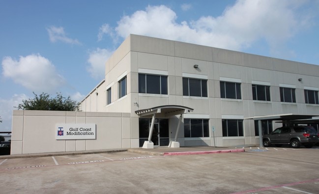
7049 W Brookhollow Dr N, Houston, TX 77040

NEARBY LISTINGS FOR SALE OR LEASE
Property Detail
7049 W Brookhollow Dr N
1160930000004
Brookhollow West Sec 5
Warehouse
RES D RESTRICTED BROOKHOLLOW WEST SEC 5
AE
Harris
48201C0635M
Texas
2024
5.44 AC
2025
Hwy 290/Tomball Pky
534203
Houston
108,000 SF
Houston-The Woodlands-Sugar Land, TX
DEMOGRAPHICS near 7049 W Brookhollow Dr N
1 Mile
3 Mile
5 Mile
2024 Total Population
4,916
70,325
259,819
2029 Population
4,933
71,066
263,529
Pop Growth 2024-2029
+ 0.35%
+ 1.05%
+ 1.43%
Average Age
37
38
37
2024 Total Households
1,962
24,685
90,623
HH Growth 2024-2029
+ 0.15%
+ 0.95%
+ 1.38%
Median Household Inc
$67,207
$72,572
$61,063
Avg Household Size
2.50
2.80
2.80
2024 Avg HH Vehicles
2.00
2.00
2.00
Median Home Value
$270,469
$237,425
$222,534
Median Year Built
1993
1990
1985
Nearby Places
Map Layers
Map Styles
 Street
 Aerial
- Restaurants
- Banks
- Shops
- Fitness
- Groceries
PUBLIC TRANSPORTATION
AIRPORT
George Bush Intcntl/Houston
DRIVE
WALK
Distance
George Bush Intcntl/Houston
27 min
20.6 mi
William P Hobby
DRIVE
WALK
Distance
William P Hobby
46 min
29.2 mi
SALE & LEASE HISTORY
LISTING DATE
SALE/LEASE

Jun 22, 2018
For Lease
Nearby Properties
Address
Land Use
TOTAL SIZE
Lot Size
Zoning
Address
Land Use
TOTAL SIZE
Lot Size
Zoning
578,530 SF
32.81 AC
Address
Land Use
TOTAL SIZE
Lot Size
Zoning
793,669 SF
121.83 AC
Address
Land Use
TOTAL SIZE
Lot Size
Zoning
664,361 SF
39.18 AC
Address
Land Use
TOTAL SIZE
Lot Size
Zoning
643,804 SF
31.40 AC
Address
Land Use
TOTAL SIZE
Lot Size
Zoning
380,959 SF
21.43 AC
Address
Land Use
TOTAL SIZE
Lot Size
Zoning
342,163 SF
8.50 AC
Address
Land Use
TOTAL SIZE
Lot Size
Zoning
397,248 SF
26.37 AC
Address
Land Use
TOTAL SIZE
Lot Size
Zoning
456,294 SF
19.02 AC
Address
Land Use
TOTAL SIZE
Lot Size
Zoning
408,730 SF
24.68 AC
Address
Land Use
TOTAL SIZE
Lot Size
Zoning
502,860 SF
40.99 AC
Address
Land Use
TOTAL SIZE
Lot Size
Zoning
281,843 SF
13.97 AC
Address
Land Use
TOTAL SIZE
Lot Size
Zoning
312,065 SF
17.83 AC
Address
Land Use
TOTAL SIZE
Lot Size
Zoning
157,698 SF
5.98 AC
Address
Land Use
TOTAL SIZE
Lot Size
Zoning
426,748 SF
26.09 AC
Address
Land Use
TOTAL SIZE
Lot Size
Zoning
401,600 SF
20.48 AC
Address
Land Use
TOTAL SIZE
Lot Size
Zoning
172,326 SF
8.07 AC
Address
Land Use
TOTAL SIZE
Lot Size
Zoning
350,057 SF
19.96 AC
Address
Land Use
TOTAL SIZE
Lot Size
Zoning
402,712 SF
25.64 AC
Address
Land Use
TOTAL SIZE
Lot Size
Zoning
347,694 SF
17.61 AC
Address
Land Use
TOTAL SIZE
Lot Size
Zoning
447,480 SF
18.48 AC
Address
Land Use
TOTAL SIZE
Lot Size
Zoning
275,561 SF
19.78 AC
Address
Land Use
TOTAL SIZE
Lot Size
Zoning
327,674 SF
15.32 AC
Address
Land Use
TOTAL SIZE
Lot Size
Zoning
357,300 SF
23.38 AC
Address
Land Use
TOTAL SIZE
Lot Size
Zoning
185,252 SF
17.14 AC
Address
Land Use
TOTAL SIZE
Lot Size
Zoning
297,351 SF
13.47 AC
Address
Land Use
TOTAL SIZE
Lot Size
Zoning
212,017 SF
14.11 AC
Address
Land Use
TOTAL SIZE
Lot Size
Zoning
251,461 SF
21.74 AC
Address
Land Use
TOTAL SIZE
Lot Size
Zoning
418,892 SF
19.81 AC
Address
Land Use
TOTAL SIZE
Lot Size
Zoning
403,200 SF
20.53 AC
Address
Land Use
TOTAL SIZE
Lot Size
Zoning
272,209 SF
18.15 AC
The World's #1 Commercial Real Estate Marketplace
Connect with us
© 2025 CoStar Group
The information above has been obtained from sources believed reliable. While we do not doubt its accuracy we have not verified it and make no guarantee, warranty or representation about it. It is your responsibility to independently confirm its accuracy and completeness. Any projections, opinions, assumptions, or estimates used are for example only and do not represent the current or future performance of the property. The value of this transaction to you depends on tax and other factors which should be evaluated by your tax, financial, and legal advisors. You and your advisors should conduct a careful, independent investigation of the property to determine to your satisfaction the suitability of the property for your needs.