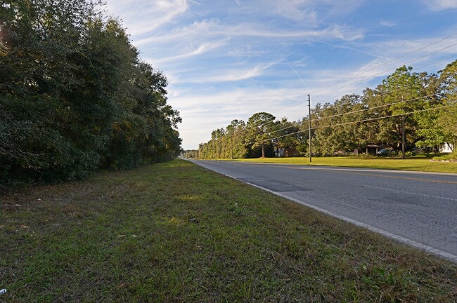
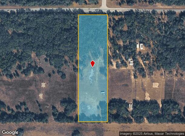
Property Record
7049 N Lecanto Hwy, Hernando, FL 34442
NEARBY LISTINGS FOR SALE OR LEASE
Property Detail
7049 N Lecanto Hwy
Homosassa Springs, FL
Unrec Tracts In 32-17S-19E
19E-17S-32-0000-41120
E1/2 OF E1/2 OF NE1/4 OF NW1/4 OF SEC 32 T17S R19E LY S OF SR 491 CITRUS CO FL ---&--- TOG W/ ING AND EGR EASE A 25 FT BY 50 FT ING AND EGR EASE BEING MORE PART DESC AS FOLL: THE N 50 FT OF THE W 25 FT OF THE FOLL DESC LANDS: THE E 1/2 OF THE E 1/2 O
Commercialacreage
Citrus
X
Florida
12017C0208D
9.16 AC
2024
Florida Central North Area
2025
Other Market Areas
450104
DEMOGRAPHICS near 7049 N Lecanto Hwy
1 Mile
3 Mile
5 Mile
2024 Total Population
526
7,100
34,536
2029 Population
603
8,172
39,424
Pop Growth 2024-2029
+ 14.64%
+ 15.10%
+ 14.15%
Average Age
51
49
48
2024 Total Households
236
3,152
15,220
HH Growth 2024-2029
+ 14.41%
+ 14.85%
+ 13.86%
Median Household Inc
$66,150
$53,311
$48,058
Avg Household Size
2.20
2.20
2.20
2024 Avg HH Vehicles
2.00
2.00
2.00
Median Home Value
$180,596
$201,637
$184,339
Median Year Built
1988
1995
1990
Nearby Places
Map Layers
Map Styles
 Street
 Aerial
- Restaurants
- Banks
- Shops
- Fitness
- Groceries
SALE & LEASE HISTORY
LISTING DATE
SALE/LEASE

Nov 26, 2019
For Sale
Mar 07, 2017
For Sale
Jul 02, 2018
For Sale
Aug 28, 2017
For Sale
Nearby Properties
Address
Land Use
TOTAL SIZE
Lot Size
Zoning
Address
Land Use
TOTAL SIZE
Lot Size
Zoning
160,267 SF
39.79 AC
PSI
Address
Land Use
TOTAL SIZE
Lot Size
Zoning
126,120 SF
115.20 AC
PDR
Address
Land Use
TOTAL SIZE
Lot Size
Zoning
13,888 SF
39.66 AC
RVP
Address
Land Use
TOTAL SIZE
Lot Size
Zoning
6,246 SF
2,813.34 AC
CON
Address
Land Use
TOTAL SIZE
Lot Size
Zoning
49,528 SF
5.77 AC
MDR
Address
Land Use
TOTAL SIZE
Lot Size
Zoning
73,037 SF
10.88 AC
GNC
Address
Land Use
TOTAL SIZE
Lot Size
Zoning
48,000 SF
2.73 AC
PDR
Address
Land Use
TOTAL SIZE
Lot Size
Zoning
133,760 SF
4.21 AC
IND
Address
Land Use
TOTAL SIZE
Lot Size
Zoning
15,558 SF
132.77 AC
PDR PLANNE
Address
Land Use
TOTAL SIZE
Lot Size
Zoning
32,000 SF
4.83 AC
IND
Address
Land Use
TOTAL SIZE
Lot Size
Zoning
11,500 SF
3.59 AC
GNC
Address
Land Use
TOTAL SIZE
Lot Size
Zoning
5,122 SF
132.87 AC
GNC
Address
Land Use
TOTAL SIZE
Lot Size
Zoning
150.34 AC
LDR
Address
Land Use
TOTAL SIZE
Lot Size
Zoning
36,800 SF
1.99 AC
IND
Address
Land Use
TOTAL SIZE
Lot Size
Zoning
6,780 SF
105.67 AC
RURMH
Address
Land Use
TOTAL SIZE
Lot Size
Zoning
18,900 SF
7.13 AC
IND
Address
Land Use
TOTAL SIZE
Lot Size
Zoning
33,890 SF
4.32 AC
IND
Address
Land Use
TOTAL SIZE
Lot Size
Zoning
14,672 SF
1.59 AC
IND
Address
Land Use
TOTAL SIZE
Lot Size
Zoning
97.69 AC
PDR
Address
Land Use
TOTAL SIZE
Lot Size
Zoning
9,100 SF
1.68 AC
GNC
Address
Land Use
TOTAL SIZE
Lot Size
Zoning
49,393 SF
7.54 AC
IND
Address
Land Use
TOTAL SIZE
Lot Size
Zoning
79,860 SF
51.26 AC
PSI
Address
Land Use
TOTAL SIZE
Lot Size
Zoning
18,000 SF
1.78 AC
IND
Address
Land Use
TOTAL SIZE
Lot Size
Zoning
11,200 SF
2.25 AC
RUR
Address
Land Use
TOTAL SIZE
Lot Size
Zoning
250.24 AC
LDRMH
Address
Land Use
TOTAL SIZE
Lot Size
Zoning
2,960 SF
14.59 AC
IND
Address
Land Use
TOTAL SIZE
Lot Size
Zoning
22,396 SF
4.29 AC
GNC
Address
Land Use
TOTAL SIZE
Lot Size
Zoning
310.85 AC
PDR
Address
Land Use
TOTAL SIZE
Lot Size
Zoning
21,300 SF
1.97 AC
IND
Address
Land Use
TOTAL SIZE
Lot Size
Zoning
5,364 SF
1.29 AC
CL
The World's #1 Commercial Real Estate Marketplace
Connect with us
© 2025 CoStar Group
The information above has been obtained from sources believed reliable. While we do not doubt its accuracy we have not verified it and make no guarantee, warranty or representation about it. It is your responsibility to independently confirm its accuracy and completeness. Any projections, opinions, assumptions, or estimates used are for example only and do not represent the current or future performance of the property. The value of this transaction to you depends on tax and other factors which should be evaluated by your tax, financial, and legal advisors. You and your advisors should conduct a careful, independent investigation of the property to determine to your satisfaction the suitability of the property for your needs.