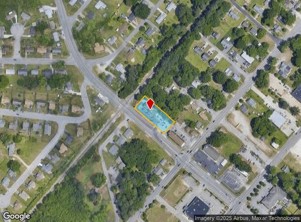
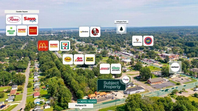
Property Record
705 Ashland Ave, Hopewell, VA 23860
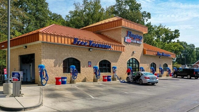
This Property Is For Sale
NEARBY LISTINGS FOR SALE OR LEASE
Property Detail
705 Ashland Ave
Richmond, VA
Cedar Level
025-0416
LOT 1 R (RESUB OF LOTS A-B-C
Carwash
Hopewell City
X
Virginia
51041C0365E
1,a-b
2025
0.57 AC
2025
TriCities
820600
Richmond VA
2,926 SF
DEMOGRAPHICS near 705 Ashland Ave
1 Mile
3 Mile
5 Mile
2024 Total Population
7,635
42,269
69,007
2029 Population
7,579
42,434
70,111
Pop Growth 2024-2029
(0.73%)
+ 0.39%
+ 1.60%
Average Age
41
37
38
2024 Total Households
3,102
13,107
23,357
HH Growth 2024-2029
(0.77%)
+ 0.20%
+ 1.58%
Median Household Inc
$52,822
$53,071
$62,174
Avg Household Size
2.40
2.50
2.50
2024 Avg HH Vehicles
2.00
2.00
2.00
Median Home Value
$131,028
$156,520
$198,066
Median Year Built
1974
1977
1979
Nearby Places
- Restaurants
- Banks
- Shops
- Fitness
- Groceries
PUBLIC TRANSPORTATION
COMMUTER RAIL
Petersburg Amtrak Station (Carolinian - Amtrak, Northeast Regional - Amtrak, Palmetto - Amtrak, Silver Meteor - Amtrak, Silver Star - Amtrak)
DRIVE
WALK
Distance
Petersburg Amtrak Station (Carolinian - Amtrak, Northeast Regional - Amtrak, Palmetto - Amtrak, Silver Meteor - Amtrak, Silver Star - Amtrak)
12 min
8.3 mi
AIRPORT
Richmond International
DRIVE
WALK
Distance
Richmond International
30 min
22.9 mi
Freight Ports
Virginia Port Authority - Richmond
DRIVE
WALK
Distance
Virginia Port Authority - Richmond
29 min
20.3 mi
Nearby Properties
Address
Land Use
TOTAL SIZE
Lot Size
Zoning
Address
Land Use
TOTAL SIZE
Lot Size
Zoning
107.29 AC
Address
Land Use
TOTAL SIZE
Lot Size
Zoning
12,840 SF
389 AC
M2
Address
Land Use
TOTAL SIZE
Lot Size
Zoning
177,075 SF
110.41 AC
R2
Address
Land Use
TOTAL SIZE
Lot Size
Zoning
15,435 SF
13.51 AC
11
Address
Land Use
TOTAL SIZE
Lot Size
Zoning
13.70 AC
B2
Address
Land Use
TOTAL SIZE
Lot Size
Zoning
97,040 SF
68.98 AC
RA
Address
Land Use
TOTAL SIZE
Lot Size
Zoning
16 AC
R3
Address
Land Use
TOTAL SIZE
Lot Size
Zoning
186,558 SF
19.06 AC
11
Address
Land Use
TOTAL SIZE
Lot Size
Zoning
10.09 AC
R4
Address
Land Use
TOTAL SIZE
Lot Size
Zoning
67,161 SF
3.06 AC
B3
Address
Land Use
TOTAL SIZE
Lot Size
Zoning
29,585 SF
5.67 AC
R4
Address
Land Use
TOTAL SIZE
Lot Size
Zoning
97,419 SF
20 AC
R1
Address
Land Use
TOTAL SIZE
Lot Size
Zoning
95,603 SF
1.99 AC
B4
Address
Land Use
TOTAL SIZE
Lot Size
Zoning
630.70 AC
A1
Address
Land Use
TOTAL SIZE
Lot Size
Zoning
10.78 AC
R4
Address
Land Use
TOTAL SIZE
Lot Size
Zoning
8,000 SF
52.80 AC
M2
Address
Land Use
TOTAL SIZE
Lot Size
Zoning
35,224 SF
3.87 AC
B1
Address
Land Use
TOTAL SIZE
Lot Size
Zoning
38,832 SF
3.33 AC
B3
Address
Land Use
TOTAL SIZE
Lot Size
Zoning
94,052 SF
4.14 AC
11
Address
Land Use
TOTAL SIZE
Lot Size
Zoning
11,250 SF
7.36 AC
M2
Address
Land Use
TOTAL SIZE
Lot Size
Zoning
46,788 SF
1.95 AC
B3
Address
Land Use
TOTAL SIZE
Lot Size
Zoning
73,071 SF
1.42 AC
B4
Address
Land Use
TOTAL SIZE
Lot Size
Zoning
45,515 SF
4.28 AC
B2
Address
Land Use
TOTAL SIZE
Lot Size
Zoning
52,342 SF
7.16 AC
B3
Address
Land Use
TOTAL SIZE
Lot Size
Zoning
79,889 SF
16.67 AC
R3
Address
Land Use
TOTAL SIZE
Lot Size
Zoning
0.25 AC
B1
Address
Land Use
TOTAL SIZE
Lot Size
Zoning
37,244 SF
2.62 AC
B3
Address
Land Use
TOTAL SIZE
Lot Size
Zoning
3.65 AC
R4
Address
Land Use
TOTAL SIZE
Lot Size
Zoning
75,410 SF
3.80 AC
11
Address
Land Use
TOTAL SIZE
Lot Size
Zoning
4.20 AC
R4
The World's #1 Commercial Real Estate Marketplace
Connect with us
© 2025 CoStar Group
The information above has been obtained from sources believed reliable. While we do not doubt its accuracy we have not verified it and make no guarantee, warranty or representation about it. It is your responsibility to independently confirm its accuracy and completeness. Any projections, opinions, assumptions, or estimates used are for example only and do not represent the current or future performance of the property. The value of this transaction to you depends on tax and other factors which should be evaluated by your tax, financial, and legal advisors. You and your advisors should conduct a careful, independent investigation of the property to determine to your satisfaction the suitability of the property for your needs.