Property Record
705 E 3Rd Ave, New Smyrna Beach, FL 32169


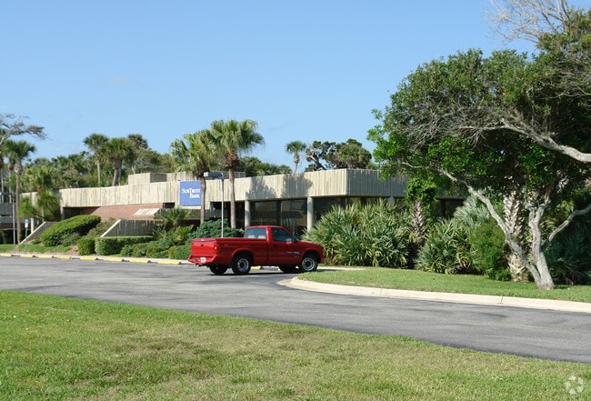
Property Detail
705 E 3Rd Ave
7416-05-28-0170
LOTS 17 TO 22 INC BLK 28 DETWILERS SUB 1ST ADD MB 7 PG 85 EXC N 6 FT OF LOTS 19 TO 21 & A PARCEL OF LAND S OF LOTS 17 TO 23 INC BLK 28 E OF SAXON RD R/W EXC S 378.13 FT & EXC W 159 FT E OF SAXON DR OF N 190 FT S OF LOTS 23 24 & 25 BLK 28 PER OR 1621
Financialbuilding
VOLUSIA
10B5
Florida
B and X Area of moderate flood hazard, usually the area between the limits of the 100-year and 500-year floods.
17-25
2025
2.68 AC
2026
South Beach Cities
082703
Deltona/Daytona Beach
11,612 SF
Deltona-Daytona Beach-Ormond Beach, FL
NEARBY LISTINGS FOR SALE OR LEASE
DEMOGRAPHICS near 705 E 3Rd Ave
1 mile
3 mile
5 mile
2025 Total Population
5,340
26,334
52,599
2030 Population
6,023
29,405
57,960
Pop Growth 2025-2030
+ 12.79%
+ 11.66%
+ 10.19%
Average Age
55
52
51
2025 Total Households
2,817
12,768
24,980
HH Growth 2025-2030
+ 12.71%
+ 12.01%
+ 10.47%
Median Household Inc
$96,884
$75,028
$69,887
Avg Household Size
1.90
1.90
2.00
2025 Avg HH Vehicles
2.00
2.00
2.00
Median Home Value
$531,018
$496,055
$412,281
Median Year Built
1988
1981
1984
Nearby Places
Map Layers
Map Styles
 Street
 Aerial
Layers
 Traffic
 Biking
Places
Listings with unknown addresses are not visible on the map
- Restaurants
- Banks
- Shops
- Fitness
- Groceries
PUBLIC TRANSPORTATION
AIRPORT
Daytona Beach International
Drive
Walk
Distance
Daytona Beach International
31 min
20.4 mi
Orlando Sanford International
Drive
Walk
Distance
Orlando Sanford International
51 min
34.2 mi
Freight Ports
Port Canaveral
Drive
Walk
Distance
Port Canaveral
77 min
62.9 mi
Nearby Properties
Address
Land Use
TOTAL SIZE
Lot Size
Zoning
Address
Land Use
TOTAL SIZE
Lot Size
Zoning
360,394 SF
65.63 AC
01R4
Address
Land Use
TOTAL SIZE
Lot Size
Zoning
177,619 SF
6.91 AC
10R2
Address
Land Use
TOTAL SIZE
Lot Size
Zoning
108,577 SF
20 AC
10R2
Address
Land Use
TOTAL SIZE
Lot Size
Zoning
209,027 SF
29.13 AC
10R2A
Address
Land Use
TOTAL SIZE
Lot Size
Zoning
115,562 SF
1.40 AC
10B4
Address
Land Use
TOTAL SIZE
Lot Size
Zoning
70,564 SF
2.09 AC
10B1
Address
Land Use
TOTAL SIZE
Lot Size
Zoning
5,796 SF
71.96 AC
R
Address
Land Use
TOTAL SIZE
Lot Size
Zoning
68,493 SF
1.89 AC
10B6
Address
Land Use
TOTAL SIZE
Lot Size
Zoning
134,246 SF
13.58 AC
10B5
Address
Land Use
TOTAL SIZE
Lot Size
Zoning
89,919 SF
1.49 AC
10B4
Address
Land Use
TOTAL SIZE
Lot Size
Zoning
0.20 AC
B46
Address
Land Use
TOTAL SIZE
Lot Size
Zoning
23,142 SF
7.98 AC
R
Address
Land Use
TOTAL SIZE
Lot Size
Zoning
91,509 SF
4.06 AC
I1
Address
Land Use
TOTAL SIZE
Lot Size
Zoning
11.87 AC
10R2A
Address
Land Use
TOTAL SIZE
Lot Size
Zoning
87,154 SF
1.08 AC
10R5
Address
Land Use
TOTAL SIZE
Lot Size
Zoning
74,609 SF
12.67 AC
10B3
Address
Land Use
TOTAL SIZE
Lot Size
Zoning
18,884 SF
12.47 AC
R
Address
Land Use
TOTAL SIZE
Lot Size
Zoning
111,686 SF
10.03 AC
10B5
Address
Land Use
TOTAL SIZE
Lot Size
Zoning
55,587 SF
85.39 AC
R4
Address
Land Use
TOTAL SIZE
Lot Size
Zoning
119,537 SF
12.06 AC
PUD
Address
Land Use
TOTAL SIZE
Lot Size
Zoning
44,239 SF
2.31 AC
10B1
Address
Land Use
TOTAL SIZE
Lot Size
Zoning
229,941 SF
0.57 AC
10R2A
Address
Land Use
TOTAL SIZE
Lot Size
Zoning
98,105 SF
8.03 AC
07B3
Address
Land Use
TOTAL SIZE
Lot Size
Zoning
41,310 SF
1.57 AC
10B1
Address
Land Use
TOTAL SIZE
Lot Size
Zoning
70,088 SF
0.30 AC
10R5
Address
Land Use
TOTAL SIZE
Lot Size
Zoning
73,711 SF
7.06 AC
R2
Address
Land Use
TOTAL SIZE
Lot Size
Zoning
11,516 SF
3.67 AC
10R5
Address
Land Use
TOTAL SIZE
Lot Size
Zoning
53,729 SF
12.70 AC
10R1
Address
Land Use
TOTAL SIZE
Lot Size
Zoning
6.39 AC
B5
Address
Land Use
TOTAL SIZE
Lot Size
Zoning
29,657 SF
2.07 AC
10R2
The World's #1 Commercial Real Estate Marketplace
Connect with us
© 2026 CoStar Group
The information above has been obtained from sources believed reliable. While we do not doubt its accuracy we have not verified it and make no guarantee, warranty or representation about it. It is your responsibility to independently confirm its accuracy and completeness. Any projections, opinions, assumptions, or estimates used are for example only and do not represent the current or future performance of the property. The value of this transaction to you depends on tax and other factors which should be evaluated by your tax, financial, and legal advisors. You and your advisors should conduct a careful, independent investigation of the property to determine to your satisfaction the suitability of the property for your needs.