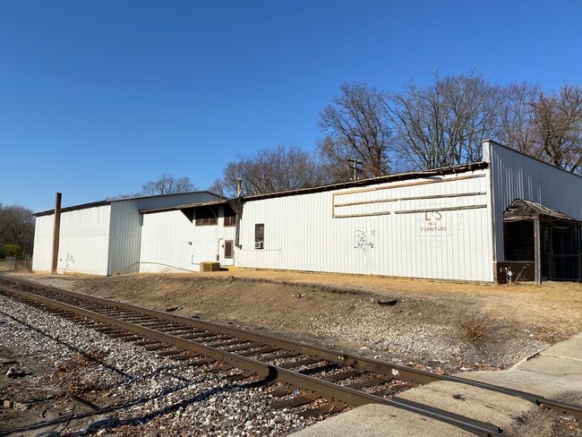
Property Record
705 N Oakland Ave, Decatur, IL 62522

NEARBY LISTINGS FOR SALE OR LEASE
Property Detail
705 N Oakland Ave
Decatur, IL
Solana Place
04-12-09-483-017
SOLANA PLACE ~S47.5 LT 6 & ALL LT 16 BLK 4 ~ IRREG ~ ~
Departmentstore
Macon
X
Illinois
17115C0301E
16-6
2024
0.44 AC
2024
Springfield/Decatur
001700
Other Market Areas
DEMOGRAPHICS near 705 N Oakland Ave
1 Mile
3 Mile
5 Mile
2024 Total Population
13,916
49,907
74,455
2029 Population
13,849
49,105
72,689
Pop Growth 2024-2029
(0.48%)
(1.61%)
(2.37%)
Average Age
36
40
41
2024 Total Households
5,636
21,464
32,535
HH Growth 2024-2029
(0.37%)
(1.68%)
(2.47%)
Median Household Inc
$34,416
$38,775
$43,057
Avg Household Size
2.10
2.10
2.10
2024 Avg HH Vehicles
1.00
1.00
2.00
Median Home Value
$70,506
$77,767
$91,224
Median Year Built
1949
1955
1960
Nearby Places
Map Layers
Map Styles
 Street
 Aerial
- Restaurants
- Banks
- Shops
- Fitness
- Groceries
SALE & LEASE HISTORY
LISTING DATE
SALE/LEASE

Jun 14, 2021
For Sale
Aug 26, 2022
For Sale
Nearby Properties
Address
Land Use
TOTAL SIZE
Lot Size
Zoning
Address
Land Use
TOTAL SIZE
Lot Size
Zoning
1.03 AC
MUNICIPAL
Address
Land Use
TOTAL SIZE
Lot Size
Zoning
1.40 AC
MUNICIPAL
Address
Land Use
TOTAL SIZE
Lot Size
Zoning
6.60 AC
MUNICIPAL
Address
Land Use
TOTAL SIZE
Lot Size
Zoning
6.68 AC
MUNICIPAL
Address
Land Use
TOTAL SIZE
Lot Size
Zoning
18.50 AC
MUNICIPAL
Address
Land Use
TOTAL SIZE
Lot Size
Zoning
6.89 AC
MUNICIPAL
Address
Land Use
TOTAL SIZE
Lot Size
Zoning
19.95 AC
MUNICIPAL
Address
Land Use
TOTAL SIZE
Lot Size
Zoning
7.82 AC
MUNICIPAL
Address
Land Use
TOTAL SIZE
Lot Size
Zoning
3.35 AC
MUNICIPAL
Address
Land Use
TOTAL SIZE
Lot Size
Zoning
1.10 AC
MUNICIPAL
Address
Land Use
TOTAL SIZE
Lot Size
Zoning
78.13 AC
MUNICIPAL
Address
Land Use
TOTAL SIZE
Lot Size
Zoning
4.82 AC
MUNICIPAL
Address
Land Use
TOTAL SIZE
Lot Size
Zoning
6.35 AC
MUNICIPAL
Address
Land Use
TOTAL SIZE
Lot Size
Zoning
3.93 AC
MUNICIPAL
Address
Land Use
TOTAL SIZE
Lot Size
Zoning
14.33 AC
MUNICIPAL
Address
Land Use
TOTAL SIZE
Lot Size
Zoning
54.49 AC
MUNICIPAL
Address
Land Use
TOTAL SIZE
Lot Size
Zoning
4.30 AC
MUNICIPAL
Address
Land Use
TOTAL SIZE
Lot Size
Zoning
0.97 AC
MUNICIPAL
Address
Land Use
TOTAL SIZE
Lot Size
Zoning
3.50 AC
MUNICIPAL
Address
Land Use
TOTAL SIZE
Lot Size
Zoning
1.73 AC
MUNICIPAL
Address
Land Use
TOTAL SIZE
Lot Size
Zoning
14.76 AC
MUNICIPAL
Address
Land Use
TOTAL SIZE
Lot Size
Zoning
3.86 AC
MUNICIPAL
Address
Land Use
TOTAL SIZE
Lot Size
Zoning
14.80 AC
MUNICIPAL
Address
Land Use
TOTAL SIZE
Lot Size
Zoning
5.18 AC
MUNICIPAL
Address
Land Use
TOTAL SIZE
Lot Size
Zoning
2.62 AC
MUNICIPAL
Address
Land Use
TOTAL SIZE
Lot Size
Zoning
9.11 AC
MUNICIPAL
Address
Land Use
TOTAL SIZE
Lot Size
Zoning
35.07 AC
MUNICIPAL
Address
Land Use
TOTAL SIZE
Lot Size
Zoning
4.21 AC
MUNICIPAL
Address
Land Use
TOTAL SIZE
Lot Size
Zoning
10.79 AC
MUNICIPAL
The World's #1 Commercial Real Estate Marketplace
Connect with us
© 2026 CoStar Group
The information above has been obtained from sources believed reliable. While we do not doubt its accuracy we have not verified it and make no guarantee, warranty or representation about it. It is your responsibility to independently confirm its accuracy and completeness. Any projections, opinions, assumptions, or estimates used are for example only and do not represent the current or future performance of the property. The value of this transaction to you depends on tax and other factors which should be evaluated by your tax, financial, and legal advisors. You and your advisors should conduct a careful, independent investigation of the property to determine to your satisfaction the suitability of the property for your needs.