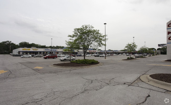
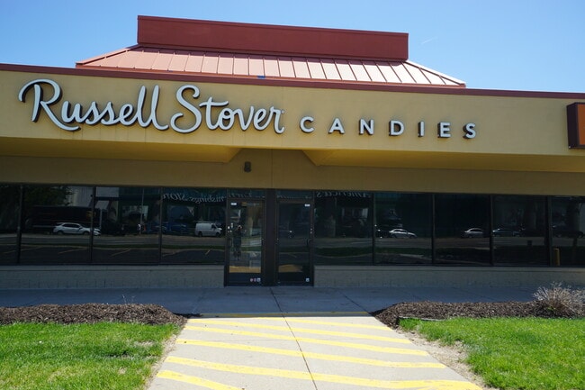
Property Record
705 S 72Nd St, Omaha, NE 68114

Save to a Folder
{{folder.Name}}
{{folder.ListingIds.length}} Properties
{{folder.ListingIds.length}} Property
Create a New Folder
Property Detail
705 S 72Nd St
3273-0002-01
LANDS SEC-TWN-RGE 24-15-12 -EX CO RD & IRREG E 25.04 W 58.04 FT- N 525 S 775 FT NW1/4 SW1/4
Storemultistory
DOUGLAS
B and X Area of moderate flood hazard, usually the area between the limits of the 100-year and 500-year floods.
Nebraska
2024
7.23 AC
2025
Central Omaha
004600
Omaha/Council Bluffs
101,571 SF
Omaha, NE-IA
NEARBY LISTINGS FOR SALE OR LEASE
DEMOGRAPHICS near 705 S 72Nd St
1 mile
3 mile
5 mile
2025 Total Population
8,262
110,117
326,395
2030 Population
8,474
113,092
335,547
Pop Growth 2025-2030
+ 2.57%
+ 2.70%
+ 2.80%
Average Age
38
38
38
2025 Total Households
3,705
49,383
136,695
HH Growth 2025-2030
+ 2.83%
+ 3.00%
+ 3.11%
Median Household Inc
$73,599
$68,915
$63,016
Avg Household Size
2.00
2.10
2.30
2025 Avg HH Vehicles
2.00
2.00
2.00
Median Home Value
$287,449
$246,678
$226,317
Median Year Built
1962
1959
1965
Nearby Places
Map Layers
Map Styles
 Street
 Aerial
Layers
 Traffic
 Biking
Places
Listings with unknown addresses are not visible on the map
- Restaurants
- Banks
- Shops
- Fitness
- Groceries
PUBLIC TRANSPORTATION
AIRPORT
Eppley Airfield
Drive
Walk
Distance
Eppley Airfield
22 min
8.8 mi
SALE & LEASE HISTORY
LISTING DATE
SALE/LEASE

Jul 21, 2021
For Lease
Nearby Properties
Address
Land Use
TOTAL SIZE
Lot Size
Zoning
Address
Land Use
TOTAL SIZE
Lot Size
Zoning
866,622 SF
20.67 AC
Address
Land Use
TOTAL SIZE
Lot Size
Zoning
255,351 SF
0.79 AC
Address
Land Use
TOTAL SIZE
Lot Size
Zoning
326,069 SF
4.88 AC
Address
Land Use
TOTAL SIZE
Lot Size
Zoning
370,431 SF
8.57 AC
Address
Land Use
TOTAL SIZE
Lot Size
Zoning
702,563 SF
18.85 AC
Address
Land Use
TOTAL SIZE
Lot Size
Zoning
687,804 SF
23.14 AC
Address
Land Use
TOTAL SIZE
Lot Size
Zoning
304,034 SF
5.11 AC
R7
Address
Land Use
TOTAL SIZE
Lot Size
Zoning
387,860 SF
7.20 AC
Address
Land Use
TOTAL SIZE
Lot Size
Zoning
398,593 SF
10.80 AC
Address
Land Use
TOTAL SIZE
Lot Size
Zoning
282,688 SF
18.71 AC
Address
Land Use
TOTAL SIZE
Lot Size
Zoning
206,591 SF
0.60 AC
Address
Land Use
TOTAL SIZE
Lot Size
Zoning
389,488 SF
4.30 AC
Address
Land Use
TOTAL SIZE
Lot Size
Zoning
145,190 SF
5.45 AC
Address
Land Use
TOTAL SIZE
Lot Size
Zoning
130,286 SF
4.31 AC
GO
Address
Land Use
TOTAL SIZE
Lot Size
Zoning
140,130 SF
1.89 AC
Address
Land Use
TOTAL SIZE
Lot Size
Zoning
96,871 SF
9.98 AC
Address
Land Use
TOTAL SIZE
Lot Size
Zoning
256,558 SF
7 AC
GI
Address
Land Use
TOTAL SIZE
Lot Size
Zoning
238,954 SF
14.65 AC
Address
Land Use
TOTAL SIZE
Lot Size
Zoning
120,078 SF
1.24 AC
MU
Address
Land Use
TOTAL SIZE
Lot Size
Zoning
329,515 SF
6.37 AC
Address
Land Use
TOTAL SIZE
Lot Size
Zoning
114,936 SF
1.93 AC
Address
Land Use
TOTAL SIZE
Lot Size
Zoning
405,820 SF
2.10 AC
Address
Land Use
TOTAL SIZE
Lot Size
Zoning
129,910 SF
0.92 AC
Address
Land Use
TOTAL SIZE
Lot Size
Zoning
646,213 SF
37.22 AC
Address
Land Use
TOTAL SIZE
Lot Size
Zoning
354,615 SF
18.13 AC
R6
Address
Land Use
TOTAL SIZE
Lot Size
Zoning
234,332 SF
12.30 AC
Address
Land Use
TOTAL SIZE
Lot Size
Zoning
112,933 SF
1.23 AC
MU
Address
Land Use
TOTAL SIZE
Lot Size
Zoning
249,902 SF
13.02 AC
CC
Address
Land Use
TOTAL SIZE
Lot Size
Zoning
407,410 SF
4.03 AC
Address
Land Use
TOTAL SIZE
Lot Size
Zoning
245,926 SF
8.80 AC
The World's #1 Commercial Real Estate Marketplace
Connect with us
© 2026 CoStar Group
The information above has been obtained from sources believed reliable. While we do not doubt its accuracy we have not verified it and make no guarantee, warranty or representation about it. It is your responsibility to independently confirm its accuracy and completeness. Any projections, opinions, assumptions, or estimates used are for example only and do not represent the current or future performance of the property. The value of this transaction to you depends on tax and other factors which should be evaluated by your tax, financial, and legal advisors. You and your advisors should conduct a careful, independent investigation of the property to determine to your satisfaction the suitability of the property for your needs.