Property Record
695 S Easy St, Lecanto, FL 34461
NEARBY LISTINGS FOR SALE OR LEASE
Property Detail
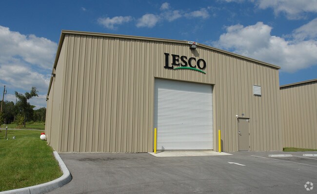
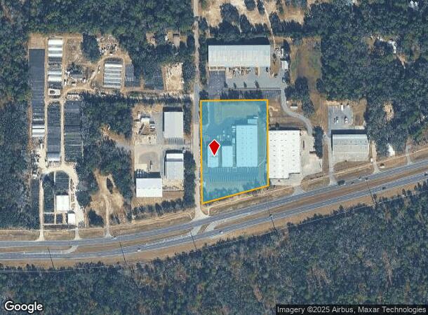
695 S Easy St
18E-19S-02-0000-1A140
Mayfield Acres Unrecorded
Warehouse
PT OF W1/2 OF SW1/4 OF NE1/4 OF SE1/4 OF SEC 2-19-18 LYING N OF SR 44 - EXC W 20 FT FOR RDWY - EXC PCL 147 LYING WITHIN FOL DESC BDRY: BEG AT PT OF INT OF E LN OF SE1/4 OF SEC 2 & CTR LN OF SURVEY OF SR 44 (SD PT BEING 1722.29 FT N 0 DEG 7M 52S W OF
X
Citrus
12017C0327D
Florida
2024
3.43 AC
2025
Florida Central North Area
450704
Other Market Areas
30,000 SF
Homosassa Springs, FL
DEMOGRAPHICS near 695 S Easy St
1 Mile
3 Mile
5 Mile
2024 Total Population
614
9,451
35,634
2029 Population
690
10,722
40,217
Pop Growth 2024-2029
+ 12.38%
+ 13.45%
+ 12.86%
Average Age
51
58
52
2024 Total Households
259
4,187
15,887
HH Growth 2024-2029
+ 11.97%
+ 13.30%
+ 12.61%
Median Household Inc
$44,939
$60,810
$49,392
Avg Household Size
2.30
2.10
2.10
2024 Avg HH Vehicles
2.00
2.00
2.00
Median Home Value
$256,488
$290,636
$224,196
Median Year Built
1991
1997
1989
Nearby Places
- Restaurants
- Banks
- Shops
- Fitness
- Groceries
SALE & LEASE HISTORY
LISTING DATE
SALE/LEASE

Sep 25, 2025
For Lease
Nearby Properties
Address
Land Use
TOTAL SIZE
Lot Size
Zoning
Address
Land Use
TOTAL SIZE
Lot Size
Zoning
198,657 SF
73.75 AC
PSI
Address
Land Use
TOTAL SIZE
Lot Size
Zoning
405,045 SF
18.52 AC
PSI
Address
Land Use
TOTAL SIZE
Lot Size
Zoning
42,396 SF
20.02 AC
PSI
Address
Land Use
TOTAL SIZE
Lot Size
Zoning
135,372 SF
4.58 AC
GNC
Address
Land Use
TOTAL SIZE
Lot Size
Zoning
57,652 SF
11.85 AC
GNC
Address
Land Use
TOTAL SIZE
Lot Size
Zoning
345,488 SF
5.87 AC
PDR
Address
Land Use
TOTAL SIZE
Lot Size
Zoning
42,134 SF
4.52 AC
GNC
Address
Land Use
TOTAL SIZE
Lot Size
Zoning
78,432 SF
18.88 AC
PSI
Address
Land Use
TOTAL SIZE
Lot Size
Zoning
76,562 SF
212.56 AC
PDR
Address
Land Use
TOTAL SIZE
Lot Size
Zoning
36,430 SF
14.26 AC
GNC
Address
Land Use
TOTAL SIZE
Lot Size
Zoning
5,526 SF
4.72 AC
GNC
Address
Land Use
TOTAL SIZE
Lot Size
Zoning
47,636 SF
8.67 AC
PSO
Address
Land Use
TOTAL SIZE
Lot Size
Zoning
33,638 SF
40.09 AC
PSI
Address
Land Use
TOTAL SIZE
Lot Size
Zoning
130,776 SF
15.64 AC
GNC
Address
Land Use
TOTAL SIZE
Lot Size
Zoning
18,714 SF
2.62 AC
PSI
Address
Land Use
TOTAL SIZE
Lot Size
Zoning
76,900 SF
4.33 AC
GNC
Address
Land Use
TOTAL SIZE
Lot Size
Zoning
17,496 SF
6.61 AC
PDR
Address
Land Use
TOTAL SIZE
Lot Size
Zoning
76,959 SF
4.67 AC
GNC
Address
Land Use
TOTAL SIZE
Lot Size
Zoning
24,938 SF
7.92 AC
GNC
Address
Land Use
TOTAL SIZE
Lot Size
Zoning
29,002 SF
9.57 AC
GNC
Address
Land Use
TOTAL SIZE
Lot Size
Zoning
11,770 SF
1.23 AC
PSO
Address
Land Use
TOTAL SIZE
Lot Size
Zoning
14.07 AC
GNC
Address
Land Use
TOTAL SIZE
Lot Size
Zoning
34,000 SF
4.22 AC
GNC
Address
Land Use
TOTAL SIZE
Lot Size
Zoning
85.65 AC
MDR
Address
Land Use
TOTAL SIZE
Lot Size
Zoning
12,134 SF
1.98 AC
GNC
Address
Land Use
TOTAL SIZE
Lot Size
Zoning
92,964 SF
4.95 AC
LIND
Address
Land Use
TOTAL SIZE
Lot Size
Zoning
2,544 SF
224.41 AC
CON
Address
Land Use
TOTAL SIZE
Lot Size
Zoning
54,650 SF
3.86 AC
GNC
Address
Land Use
TOTAL SIZE
Lot Size
Zoning
44,370 SF
1.55 AC
PSO
The World's #1 Commercial Real Estate Marketplace
Connect with us
© 2025 CoStar Group
The information above has been obtained from sources believed reliable. While we do not doubt its accuracy we have not verified it and make no guarantee, warranty or representation about it. It is your responsibility to independently confirm its accuracy and completeness. Any projections, opinions, assumptions, or estimates used are for example only and do not represent the current or future performance of the property. The value of this transaction to you depends on tax and other factors which should be evaluated by your tax, financial, and legal advisors. You and your advisors should conduct a careful, independent investigation of the property to determine to your satisfaction the suitability of the property for your needs.