Property Record
705 Sound Ave, Mattituck, NY 11952
NEARBY LISTINGS FOR SALE OR LEASE
Property Detail
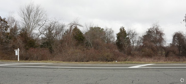
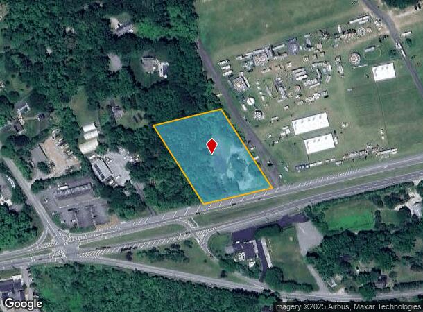
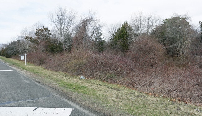
705 Sound Ave
Nassau County-Suffolk County, NY
BOOK 3 PAGE 00149 BILL 014307
1000-113-00-12-00-013-000
Suffolk
Commercialacreage
New York
X
13
36103C0481H
2.76 AC
2024
Eastern Suffolk
2024
Long Island (New York)
170004
DEMOGRAPHICS near 705 Sound Ave
1 Mile
3 Mile
5 Mile
2024 Total Population
1,802
7,488
13,922
2029 Population
1,813
7,561
13,947
Pop Growth 2024-2029
+ 0.61%
+ 0.97%
+ 0.18%
Average Age
46
46
47
2024 Total Households
737
2,979
5,509
HH Growth 2024-2029
+ 0.27%
+ 0.70%
(0.13%)
Median Household Inc
$96,921
$99,933
$104,895
Avg Household Size
2.40
2.40
2.40
2024 Avg HH Vehicles
2.00
2.00
2.00
Median Home Value
$719,631
$720,817
$732,823
Median Year Built
1974
1975
1976
Nearby Places
- Restaurants
- Banks
- Shops
- Fitness
- Groceries
PUBLIC TRANSPORTATION
COMMUTER RAIL
Mattituck Station (Greenport Branch - Long Island Rail Road)
DRIVE
WALK
Distance
Mattituck Station (Greenport Branch - Long Island Rail Road)
3 min
17 min
0.9 mi
Riverhead Station (Greenport Branch - Long Island Rail Road)
DRIVE
WALK
Distance
Riverhead Station (Greenport Branch - Long Island Rail Road)
17 min
9.1 mi
AIRPORT
Long Island MacArthur
DRIVE
WALK
Distance
Long Island MacArthur
51 min
36.6 mi
SALE & LEASE HISTORY
LISTING DATE
SALE/LEASE

Aug 22, 2024
For Sale
Nearby Properties
Address
Land Use
TOTAL SIZE
Lot Size
Zoning
Address
Land Use
TOTAL SIZE
Lot Size
Zoning
214.30 AC
10
Address
Land Use
TOTAL SIZE
Lot Size
Zoning
30.40 AC
R-80
Address
Land Use
TOTAL SIZE
Lot Size
Zoning
1,688 SF
34.47 AC
09
Address
Land Use
TOTAL SIZE
Lot Size
Zoning
5.01 AC
10
Address
Land Use
TOTAL SIZE
Lot Size
Zoning
5,338 SF
159.30 AC
4
Address
Land Use
TOTAL SIZE
Lot Size
Zoning
11.39 AC
10
Address
Land Use
TOTAL SIZE
Lot Size
Zoning
1,980 SF
63.11 AC
09
Address
Land Use
TOTAL SIZE
Lot Size
Zoning
2,928 SF
85.90 AC
04
Address
Land Use
TOTAL SIZE
Lot Size
Zoning
392 SF
52.39 AC
09
Address
Land Use
TOTAL SIZE
Lot Size
Zoning
2,392 SF
26.20 AC
09
Address
Land Use
TOTAL SIZE
Lot Size
Zoning
9,230 SF
19.70 AC
04
Address
Land Use
TOTAL SIZE
Lot Size
Zoning
7,013 SF
2.34 AC
04
Address
Land Use
TOTAL SIZE
Lot Size
Zoning
3,945 SF
6.27 AC
APZ
Address
Land Use
TOTAL SIZE
Lot Size
Zoning
392 SF
19.31 AC
09
Address
Land Use
TOTAL SIZE
Lot Size
Zoning
2,526 SF
41 AC
04
Address
Land Use
TOTAL SIZE
Lot Size
Zoning
2,112 SF
23.30 AC
09
Address
Land Use
TOTAL SIZE
Lot Size
Zoning
0.79 AC
VILLA
Address
Land Use
TOTAL SIZE
Lot Size
Zoning
8.75 AC
B
Address
Land Use
TOTAL SIZE
Lot Size
Zoning
5,483 SF
18.43 AC
04
Address
Land Use
TOTAL SIZE
Lot Size
Zoning
2,317 SF
0.71 AC
04
Address
Land Use
TOTAL SIZE
Lot Size
Zoning
82.20 AC
04
Address
Land Use
TOTAL SIZE
Lot Size
Zoning
6,681 SF
4 AC
04
Address
Land Use
TOTAL SIZE
Lot Size
Zoning
3,620 SF
11.50 AC
04
Address
Land Use
TOTAL SIZE
Lot Size
Zoning
41.20 AC
03
Address
Land Use
TOTAL SIZE
Lot Size
Zoning
Address
Land Use
TOTAL SIZE
Lot Size
Zoning
7.87 AC
RA80
Address
Land Use
TOTAL SIZE
Lot Size
Zoning
2,900 SF
4.17 AC
APZ
Address
Land Use
TOTAL SIZE
Lot Size
Zoning
31.40 AC
09
Address
Land Use
TOTAL SIZE
Lot Size
Zoning
Address
Land Use
TOTAL SIZE
Lot Size
Zoning
2,699 SF
21 AC
04
The World's #1 Commercial Real Estate Marketplace
Connect with us
© 2025 CoStar Group
The information above has been obtained from sources believed reliable. While we do not doubt its accuracy we have not verified it and make no guarantee, warranty or representation about it. It is your responsibility to independently confirm its accuracy and completeness. Any projections, opinions, assumptions, or estimates used are for example only and do not represent the current or future performance of the property. The value of this transaction to you depends on tax and other factors which should be evaluated by your tax, financial, and legal advisors. You and your advisors should conduct a careful, independent investigation of the property to determine to your satisfaction the suitability of the property for your needs.