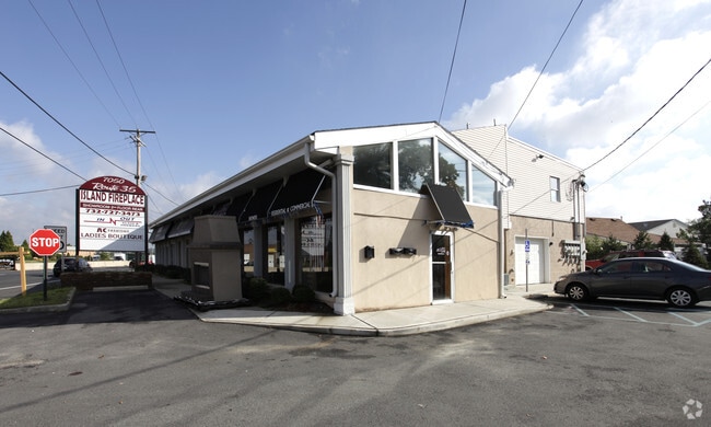
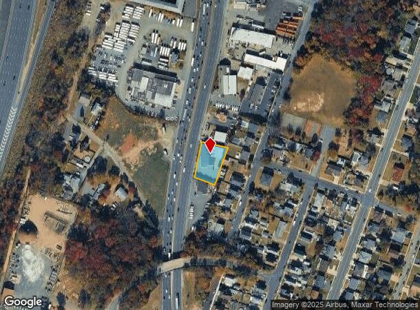
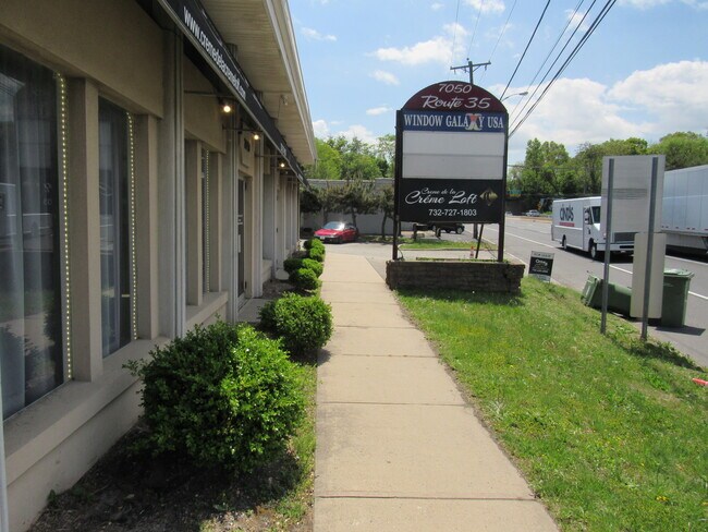
Property Record
7050 State Route 35, South Amboy, NJ 08879


Current Lease Availabilities
NEARBY LISTINGS FOR SALE OR LEASE
Property Detail
7050 State Route 35
New York-Jersey City-White Plains, NY-NJ
148X112 16.02,17.01
19-00276-0000-00004
Middlesex
Storemultistory
New Jersey
X
4
34023C0156F
0.38 AC
2024
South Edison
2025
Northern New Jersey
009200
DEMOGRAPHICS near 7050 State Route 35
1 Mile
3 Mile
5 Mile
2024 Total Population
5,192
104,278
220,078
2029 Population
5,167
102,135
217,163
Pop Growth 2024-2029
(0.48%)
(2.06%)
(1.32%)
Average Age
41
39
40
2024 Total Households
2,048
36,226
79,588
HH Growth 2024-2029
(0.44%)
(1.91%)
(1.29%)
Median Household Inc
$92,638
$74,300
$87,891
Avg Household Size
2.50
2.80
2.70
2024 Avg HH Vehicles
2.00
2.00
2.00
Median Home Value
$329,850
$353,551
$371,582
Median Year Built
1959
1963
1966
Nearby Places
- Restaurants
- Banks
- Shops
- Fitness
- Groceries
PUBLIC TRANSPORTATION
COMMUTER RAIL
South Amboy (North Jersey Coast Line - NJ Transit Commuter Rail (NJ Transit))
DRIVE
WALK
Distance
South Amboy (North Jersey Coast Line - NJ Transit Commuter Rail (NJ Transit))
5 min
1.9 mi
Perth Amboy (North Jersey Coast Line - NJ Transit Commuter Rail (NJ Transit))
DRIVE
WALK
Distance
Perth Amboy (North Jersey Coast Line - NJ Transit Commuter Rail (NJ Transit))
5 min
2.6 mi
AIRPORT
Newark Liberty International
DRIVE
WALK
Distance
Newark Liberty International
29 min
20.5 mi
LaGuardia
DRIVE
WALK
Distance
LaGuardia
58 min
37.8 mi
John F Kennedy International
DRIVE
WALK
Distance
John F Kennedy International
60 min
41.0 mi
Freight Ports
New York Container Terminal
DRIVE
WALK
Distance
New York Container Terminal
22 min
15.6 mi
Nearby Properties
Address
Land Use
TOTAL SIZE
Lot Size
Zoning
Address
Land Use
TOTAL SIZE
Lot Size
Zoning
1,889 SF
235.62 AC
Address
Land Use
TOTAL SIZE
Lot Size
Zoning
53.04 AC
S-1F
Address
Land Use
TOTAL SIZE
Lot Size
Zoning
10.69 AC
R-MM
Address
Land Use
TOTAL SIZE
Lot Size
Zoning
15.15 AC
RMMF
Address
Land Use
TOTAL SIZE
Lot Size
Zoning
Address
Land Use
TOTAL SIZE
Lot Size
Zoning
2.14 AC
C-4
Address
Land Use
TOTAL SIZE
Lot Size
Zoning
2.51 AC
H
Address
Land Use
TOTAL SIZE
Lot Size
Zoning
Address
Land Use
TOTAL SIZE
Lot Size
Zoning
6.79 AC
R-50
Address
Land Use
TOTAL SIZE
Lot Size
Zoning
7.23 AC
S-2A
Address
Land Use
TOTAL SIZE
Lot Size
Zoning
27.36 AC
Address
Land Use
TOTAL SIZE
Lot Size
Zoning
726 SF
75.46 AC
P
Address
Land Use
TOTAL SIZE
Lot Size
Zoning
7,904 SF
60 AC
AF
Address
Land Use
TOTAL SIZE
Lot Size
Zoning
53.95 AC
RRRD
Address
Land Use
TOTAL SIZE
Lot Size
Zoning
Address
Land Use
TOTAL SIZE
Lot Size
Zoning
90.33 AC
Address
Land Use
TOTAL SIZE
Lot Size
Zoning
276 SF
6.59 AC
S-2A
Address
Land Use
TOTAL SIZE
Lot Size
Zoning
23.01 AC
S-1F
Address
Land Use
TOTAL SIZE
Lot Size
Zoning
31.22 AC
G1
Address
Land Use
TOTAL SIZE
Lot Size
Zoning
9.72 AC
M-1
Address
Land Use
TOTAL SIZE
Lot Size
Zoning
317 SF
11.60 AC
R-MM
Address
Land Use
TOTAL SIZE
Lot Size
Zoning
1.58 AC
Address
Land Use
TOTAL SIZE
Lot Size
Zoning
3.29 AC
M1
Address
Land Use
TOTAL SIZE
Lot Size
Zoning
14,270 SF
7.42 AC
R-MM
Address
Land Use
TOTAL SIZE
Lot Size
Zoning
8.90 AC
S-1A
Address
Land Use
TOTAL SIZE
Lot Size
Zoning
136,121 SF
12.84 AC
RB
Address
Land Use
TOTAL SIZE
Lot Size
Zoning
Address
Land Use
TOTAL SIZE
Lot Size
Zoning
25.82 AC
RRRD
Address
Land Use
TOTAL SIZE
Lot Size
Zoning
169.71 AC
I
Address
Land Use
TOTAL SIZE
Lot Size
Zoning
6.19 AC
R-MM
The World's #1 Commercial Real Estate Marketplace
Connect with us
© 2025 CoStar Group
The information above has been obtained from sources believed reliable. While we do not doubt its accuracy we have not verified it and make no guarantee, warranty or representation about it. It is your responsibility to independently confirm its accuracy and completeness. Any projections, opinions, assumptions, or estimates used are for example only and do not represent the current or future performance of the property. The value of this transaction to you depends on tax and other factors which should be evaluated by your tax, financial, and legal advisors. You and your advisors should conduct a careful, independent investigation of the property to determine to your satisfaction the suitability of the property for your needs.