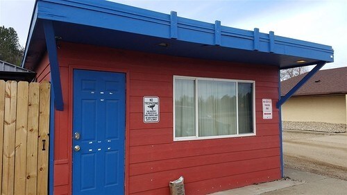
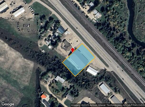
Property Record
7051 Highway 2 And 52 W, Minot, ND 58703

NEARBY LISTINGS FOR SALE OR LEASE
-
-
View all Minot listings for sale on LoopNet.com
Property Detail
7051 Highway 2 And 52 W
Other Market Areas
Speedway 3Rd Addition
Minot, ND
Ward
HA181480000030
North Dakota
Singlefamilyresidentialassumed
1.44 AC
21,390 SF
Souris Valley
DEMOGRAPHICS near 7051 Highway 2 And 52 W
1 Mile
3 Mile
5 Mile
2024 Total Population
728
4,037
27,590
2029 Population
713
3,939
27,075
Pop Growth 2024-2029
(2.06%)
(2.43%)
(1.87%)
Average Age
38
38
37
2024 Total Households
286
1,582
11,338
HH Growth 2024-2029
(2.10%)
(2.47%)
(1.99%)
Median Household Inc
$70,440
$69,765
$73,952
Avg Household Size
2.50
2.50
2.30
2024 Avg HH Vehicles
3.00
2.00
2.00
Median Home Value
$296,773
$272,254
$244,138
Median Year Built
1997
1992
1981
Nearby Places
- Restaurants
- Banks
- Shops
- Fitness
- Groceries
PUBLIC TRANSPORTATION
COMMUTER RAIL
Minot Amtrak Station (Empire Builder - Amtrak)
DRIVE
WALK
Distance
Minot Amtrak Station (Empire Builder - Amtrak)
9 min
6.1 mi
AIRPORT
Minot International
DRIVE
WALK
Distance
Minot International
14 min
8.4 mi
Freight Ports
Port Milwaukee
DRIVE
WALK
Distance
Port Milwaukee
947 min
875.4 mi
SALE & LEASE HISTORY
LISTING DATE
SALE/LEASE

Oct 12, 2017
For Sale
Nearby Properties
Address
Land Use
TOTAL SIZE
Lot Size
Zoning
Address
Land Use
TOTAL SIZE
Lot Size
Zoning
5,760 SF
52.59 AC
Address
Land Use
TOTAL SIZE
Lot Size
Zoning
1,600 SF
2.01 AC
Address
Land Use
TOTAL SIZE
Lot Size
Zoning
10,800 SF
2 AC
Address
Land Use
TOTAL SIZE
Lot Size
Zoning
Address
Land Use
TOTAL SIZE
Lot Size
Zoning
5,280 SF
3.29 AC
Address
Land Use
TOTAL SIZE
Lot Size
Zoning
2,600 SF
2.02 AC
Address
Land Use
TOTAL SIZE
Lot Size
Zoning
4,032 SF
0.95 AC
Address
Land Use
TOTAL SIZE
Lot Size
Zoning
9.59 AC
Address
Land Use
TOTAL SIZE
Lot Size
Zoning
1,792 SF
1 AC
Address
Land Use
TOTAL SIZE
Lot Size
Zoning
2,966 SF
2.02 AC
Address
Land Use
TOTAL SIZE
Lot Size
Zoning
148.16 AC
Address
Land Use
TOTAL SIZE
Lot Size
Zoning
22.04 AC
Address
Land Use
TOTAL SIZE
Lot Size
Zoning
Address
Land Use
TOTAL SIZE
Lot Size
Zoning
4.02 AC
Address
Land Use
TOTAL SIZE
Lot Size
Zoning
15.16 AC
Address
Land Use
TOTAL SIZE
Lot Size
Zoning
20.16 AC
Address
Land Use
TOTAL SIZE
Lot Size
Zoning
9.07 AC
Address
Land Use
TOTAL SIZE
Lot Size
Zoning
2.89 AC
Address
Land Use
TOTAL SIZE
Lot Size
Zoning
2.68 AC
Address
Land Use
TOTAL SIZE
Lot Size
Zoning
1.06 AC
Address
Land Use
TOTAL SIZE
Lot Size
Zoning
2.70 AC
Address
Land Use
TOTAL SIZE
Lot Size
Zoning
2.66 AC
Address
Land Use
TOTAL SIZE
Lot Size
Zoning
6.78 AC
Address
Land Use
TOTAL SIZE
Lot Size
Zoning
2.49 AC
Address
Land Use
TOTAL SIZE
Lot Size
Zoning
2.43 AC
Address
Land Use
TOTAL SIZE
Lot Size
Zoning
2.46 AC
Address
Land Use
TOTAL SIZE
Lot Size
Zoning
2.40 AC
Address
Land Use
TOTAL SIZE
Lot Size
Zoning
2.37 AC
Address
Land Use
TOTAL SIZE
Lot Size
Zoning
2.37 AC
The World's #1 Commercial Real Estate Marketplace
Connect with us
© 2025 CoStar Group
The information above has been obtained from sources believed reliable. While we do not doubt its accuracy we have not verified it and make no guarantee, warranty or representation about it. It is your responsibility to independently confirm its accuracy and completeness. Any projections, opinions, assumptions, or estimates used are for example only and do not represent the current or future performance of the property. The value of this transaction to you depends on tax and other factors which should be evaluated by your tax, financial, and legal advisors. You and your advisors should conduct a careful, independent investigation of the property to determine to your satisfaction the suitability of the property for your needs.