Property Record
7051 S Pine St, Pacolet, SC 29372
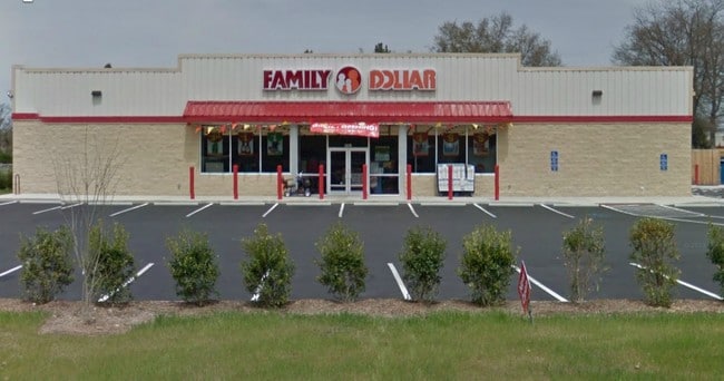

Property Detail
7051 S Pine St
Spartanburg, SC
LOTS 2 & 3 SPARTANBURG COUNTY SCHOOL DIST 3 PACOLET HIGH SCHOOL SURVEY PB 93-549 PB 166-372
3-33-03-003.09
Spartanburg
Commercialnec
South Carolina
B and X Area of moderate flood hazard, usually the area between the limits of the 100-year and 500-year floods.
2,3
2024
1.30 AC
2025
Lower Spartanburg Cty
023902
Greenville/Spartanburg
8,137 SF
NEARBY LISTINGS FOR SALE OR LEASE
-
-
View all Pacolet listings for sale on LoopNet.com
DEMOGRAPHICS near 7051 S Pine St
1 mile
3 mile
5 mile
2025 Total Population
1,797
4,884
8,162
2030 Population
2,004
5,393
8,959
Pop Growth 2025-2030
+ 11.52%
+ 10.42%
+ 9.76%
Average Age
42
42
42
2025 Total Households
734
1,991
3,342
HH Growth 2025-2030
+ 11.58%
+ 10.45%
+ 9.78%
Median Household Inc
$51,294
$54,681
$60,023
Avg Household Size
2.50
2.50
2.40
2025 Avg HH Vehicles
2.00
2.00
2.00
Median Home Value
$124,367
$139,164
$168,137
Median Year Built
1967
1970
1977
Nearby Places
Map Layers
Map Styles
 Street
 Aerial
Layers
 Traffic
 Biking
Places
Listings with unknown addresses are not visible on the map
- Restaurants
- Banks
- Shops
- Fitness
- Groceries
PUBLIC TRANSPORTATION
AIRPORT
Greenville Spartanburg International
Drive
Walk
Distance
Greenville Spartanburg International
49 min
32.8 mi
SALE & LEASE HISTORY
LISTING DATE
SALE/LEASE

Aug 04, 2020
For Sale
Nearby Properties
Address
Land Use
TOTAL SIZE
Lot Size
Zoning
Address
Land Use
TOTAL SIZE
Lot Size
Zoning
793 SF
6.14 AC
Address
Land Use
TOTAL SIZE
Lot Size
Zoning
237.17 AC
Address
Land Use
TOTAL SIZE
Lot Size
Zoning
3,281 SF
Address
Land Use
TOTAL SIZE
Lot Size
Zoning
2,088 SF
9.03 AC
Address
Land Use
TOTAL SIZE
Lot Size
Zoning
2,550 SF
64.61 AC
Address
Land Use
TOTAL SIZE
Lot Size
Zoning
2,327 SF
0.59 AC
Address
Land Use
TOTAL SIZE
Lot Size
Zoning
1,915 SF
2.49 AC
Address
Land Use
TOTAL SIZE
Lot Size
Zoning
1,938 SF
1.19 AC
Address
Land Use
TOTAL SIZE
Lot Size
Zoning
2,924 SF
0.93 AC
Address
Land Use
TOTAL SIZE
Lot Size
Zoning
78.07 AC
Address
Land Use
TOTAL SIZE
Lot Size
Zoning
1,618 SF
0.52 AC
Address
Land Use
TOTAL SIZE
Lot Size
Zoning
2,026 SF
0.59 AC
Address
Land Use
TOTAL SIZE
Lot Size
Zoning
1,784 SF
1.23 AC
Address
Land Use
TOTAL SIZE
Lot Size
Zoning
165.25 AC
Address
Land Use
TOTAL SIZE
Lot Size
Zoning
2,010 SF
0.93 AC
Address
Land Use
TOTAL SIZE
Lot Size
Zoning
35,328 SF
9 AC
Address
Land Use
TOTAL SIZE
Lot Size
Zoning
1,675 SF
1.52 AC
Address
Land Use
TOTAL SIZE
Lot Size
Zoning
139,336 SF
6 AC
Address
Land Use
TOTAL SIZE
Lot Size
Zoning
1,500 SF
1.51 AC
Address
Land Use
TOTAL SIZE
Lot Size
Zoning
798 SF
164 AC
Address
Land Use
TOTAL SIZE
Lot Size
Zoning
2,640 SF
4.49 AC
Address
Land Use
TOTAL SIZE
Lot Size
Zoning
8,750 SF
0.90 AC
Address
Land Use
TOTAL SIZE
Lot Size
Zoning
30,150 SF
1.60 AC
Address
Land Use
TOTAL SIZE
Lot Size
Zoning
260.01 AC
Address
Land Use
TOTAL SIZE
Lot Size
Zoning
14,785 SF
0.65 AC
Address
Land Use
TOTAL SIZE
Lot Size
Zoning
3,552 SF
0.59 AC
Address
Land Use
TOTAL SIZE
Lot Size
Zoning
12,234 SF
1.03 AC
Address
Land Use
TOTAL SIZE
Lot Size
Zoning
2.51 AC
Address
Land Use
TOTAL SIZE
Lot Size
Zoning
2,393 SF
1.02 AC
Address
Land Use
TOTAL SIZE
Lot Size
Zoning
7,808 SF
120.93 AC
The World's #1 Commercial Real Estate Marketplace
Connect with us
© 2026 CoStar Group
The information above has been obtained from sources believed reliable. While we do not doubt its accuracy we have not verified it and make no guarantee, warranty or representation about it. It is your responsibility to independently confirm its accuracy and completeness. Any projections, opinions, assumptions, or estimates used are for example only and do not represent the current or future performance of the property. The value of this transaction to you depends on tax and other factors which should be evaluated by your tax, financial, and legal advisors. You and your advisors should conduct a careful, independent investigation of the property to determine to your satisfaction the suitability of the property for your needs.