Property Record
7055 Avery Rd, Dublin, OH 43017
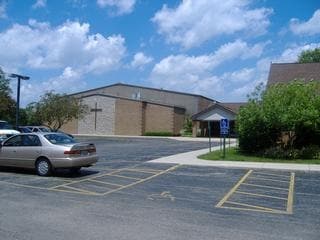


Property Detail
7055 Avery Rd
273-001821
7055 AVERY ROAD ENTRY 3010-2999 5.725 ACRES
Religious
Franklin
B and X Area of moderate flood hazard, usually the area between the limits of the 100-year and 500-year floods.
Ohio
0
5.73 AC
2025
Dublin
010402
Columbus
21,386 SF
Columbus, OH
NEARBY LISTINGS FOR SALE OR LEASE
-
-
View all Dublin listings for sale on LoopNet.com
DEMOGRAPHICS near 7055 Avery Rd
1 mile
3 mile
5 mile
2025 Total Population
10,739
48,010
147,131
2030 Population
11,145
50,120
153,737
Pop Growth 2025-2030
+ 3.78%
+ 4.39%
+ 4.49%
Average Age
39
40
39
2025 Total Households
3,607
17,217
58,156
HH Growth 2025-2030
+ 3.83%
+ 4.43%
+ 4.37%
Median Household Inc
$142,916
$146,216
$112,518
Avg Household Size
2.90
2.80
2.50
2025 Avg HH Vehicles
2.00
2.00
2.00
Median Home Value
$497,432
$577,204
$462,192
Median Year Built
1994
1996
1995
Nearby Places
Map Layers
Map Styles
 Street
 Aerial
Layers
 Traffic
 Biking
Places
Listings with unknown addresses are not visible on the map
- Restaurants
- Banks
- Shops
- Fitness
- Groceries
PUBLIC TRANSPORTATION
AIRPORT
John Glenn Columbus International
Drive
Walk
Distance
John Glenn Columbus International
34 min
24.1 mi
Rickenbacker International
Drive
Walk
Distance
Rickenbacker International
43 min
29.8 mi
Nearby Properties
Address
Land Use
TOTAL SIZE
Lot Size
Zoning
Address
Land Use
TOTAL SIZE
Lot Size
Zoning
464,088 SF
45.57 AC
Address
Land Use
TOTAL SIZE
Lot Size
Zoning
768,498 SF
66.96 AC
Address
Land Use
TOTAL SIZE
Lot Size
Zoning
256,984 SF
10.49 AC
Address
Land Use
TOTAL SIZE
Lot Size
Zoning
419,285 SF
17.19 AC
Address
Land Use
TOTAL SIZE
Lot Size
Zoning
297,024 SF
71.76 AC
Address
Land Use
TOTAL SIZE
Lot Size
Zoning
Address
Land Use
TOTAL SIZE
Lot Size
Zoning
173,618 SF
1.13 AC
Address
Land Use
TOTAL SIZE
Lot Size
Zoning
223,270 SF
1.30 AC
Address
Land Use
TOTAL SIZE
Lot Size
Zoning
4,788 SF
96.85 AC
Address
Land Use
TOTAL SIZE
Lot Size
Zoning
178,568 SF
31.62 AC
Address
Land Use
TOTAL SIZE
Lot Size
Zoning
95,447 SF
58.80 AC
Address
Land Use
TOTAL SIZE
Lot Size
Zoning
129,283 SF
56.69 AC
Address
Land Use
TOTAL SIZE
Lot Size
Zoning
42,494 SF
0.19 AC
Address
Land Use
TOTAL SIZE
Lot Size
Zoning
143,277 SF
15.54 AC
Address
Land Use
TOTAL SIZE
Lot Size
Zoning
414,372 SF
24.87 AC
Address
Land Use
TOTAL SIZE
Lot Size
Zoning
216,795 SF
10.21 AC
Address
Land Use
TOTAL SIZE
Lot Size
Zoning
245,705 SF
6.50 AC
Address
Land Use
TOTAL SIZE
Lot Size
Zoning
186,094 SF
13.06 AC
Address
Land Use
TOTAL SIZE
Lot Size
Zoning
59,144 SF
87.61 AC
Address
Land Use
TOTAL SIZE
Lot Size
Zoning
111,376 SF
0.55 AC
Address
Land Use
TOTAL SIZE
Lot Size
Zoning
122,663 SF
0.60 AC
Address
Land Use
TOTAL SIZE
Lot Size
Zoning
131,940 SF
34.46 AC
Address
Land Use
TOTAL SIZE
Lot Size
Zoning
365,841 SF
30.07 AC
Address
Land Use
TOTAL SIZE
Lot Size
Zoning
303,819 SF
54.15 AC
Address
Land Use
TOTAL SIZE
Lot Size
Zoning
120,270 SF
14.68 AC
Address
Land Use
TOTAL SIZE
Lot Size
Zoning
131,905 SF
6.32 AC
Address
Land Use
TOTAL SIZE
Lot Size
Zoning
133,091 SF
15.01 AC
Address
Land Use
TOTAL SIZE
Lot Size
Zoning
227,504 SF
23.26 AC
Address
Land Use
TOTAL SIZE
Lot Size
Zoning
105,694 SF
14.51 AC
Address
Land Use
TOTAL SIZE
Lot Size
Zoning
101,049 SF
0.65 AC
The World's #1 Commercial Real Estate Marketplace
Connect with us
© 2026 CoStar Group
The information above has been obtained from sources believed reliable. While we do not doubt its accuracy we have not verified it and make no guarantee, warranty or representation about it. It is your responsibility to independently confirm its accuracy and completeness. Any projections, opinions, assumptions, or estimates used are for example only and do not represent the current or future performance of the property. The value of this transaction to you depends on tax and other factors which should be evaluated by your tax, financial, and legal advisors. You and your advisors should conduct a careful, independent investigation of the property to determine to your satisfaction the suitability of the property for your needs.