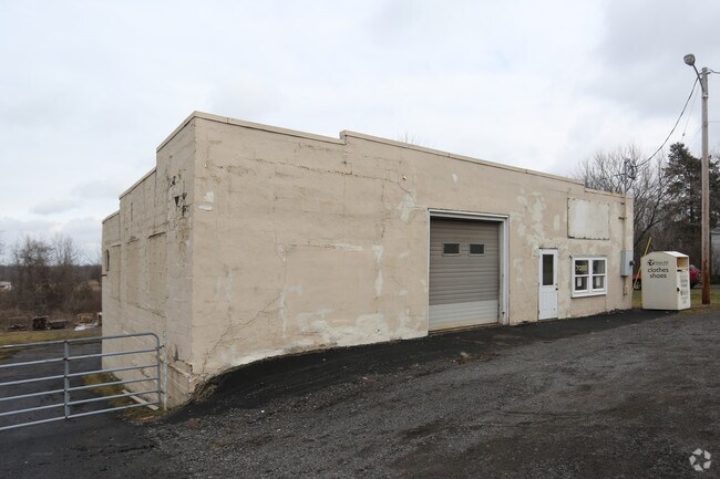
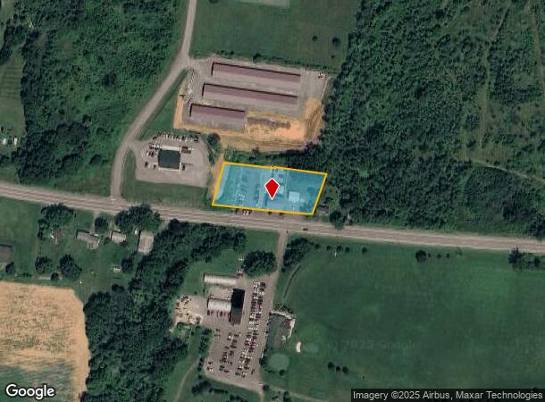
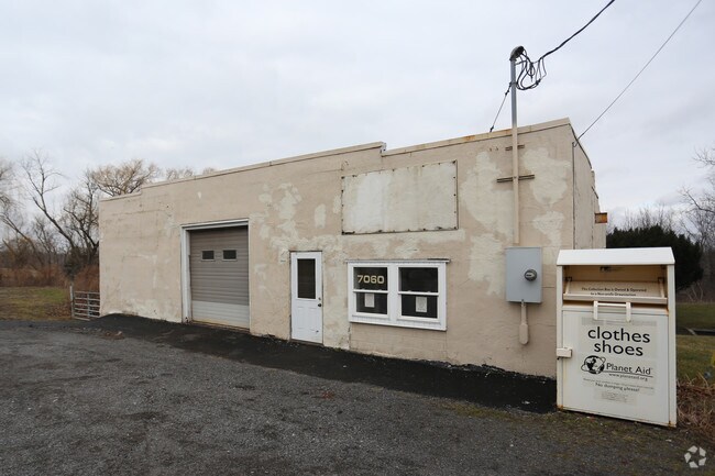
Property Record
7056 W Ridge Rd, Brockport, NY 14420

NEARBY LISTINGS FOR SALE OR LEASE
-
-
View all Brockport listings for sale on LoopNet.com
Property Detail
7056 W Ridge Rd
262489-055-040-0001-015-100
Monroe
Autorepair
New York
X
15.100
36055C0155G
1.43 AC
2025
Northwest
2024
Rochester
015200
Rochester, NY
2,000 SF
DEMOGRAPHICS near 7056 W Ridge Rd
1 Mile
3 Mile
5 Mile
2024 Total Population
295
6,476
31,492
2029 Population
293
6,410
31,138
Pop Growth 2024-2029
(0.68%)
(1.02%)
(1.12%)
Average Age
43
43
40
2024 Total Households
116
2,537
12,260
HH Growth 2024-2029
(0.86%)
(1.06%)
(1.17%)
Median Household Inc
$87,500
$88,416
$68,412
Avg Household Size
2.50
2.50
2.40
2024 Avg HH Vehicles
2.00
2.00
2.00
Median Home Value
$212,121
$192,545
$181,689
Median Year Built
1979
1977
1973
Nearby Places
- Restaurants
- Banks
- Shops
- Fitness
- Groceries
PUBLIC TRANSPORTATION
AIRPORT
Frederick Douglass/Greater Rochester International
DRIVE
WALK
Distance
Frederick Douglass/Greater Rochester International
26 min
17.3 mi
Freight Ports
Albany, NY Port
DRIVE
WALK
Distance
Albany, NY Port
290 min
243.3 mi
Nearby Properties
Address
Land Use
TOTAL SIZE
Lot Size
Zoning
Address
Land Use
TOTAL SIZE
Lot Size
Zoning
226,580 SF
8.70 AC
06 - INDUS
Address
Land Use
TOTAL SIZE
Lot Size
Zoning
29,621 SF
21.57 AC
06 - INDUS
Address
Land Use
TOTAL SIZE
Lot Size
Zoning
30,960 SF
7.36 AC
RS-10
Address
Land Use
TOTAL SIZE
Lot Size
Zoning
5,600 SF
3.93 AC
05 - COMME
Address
Land Use
TOTAL SIZE
Lot Size
Zoning
10,800 SF
135.13 AC
RS-20
Address
Land Use
TOTAL SIZE
Lot Size
Zoning
5,660 SF
2.97 AC
HC
Address
Land Use
TOTAL SIZE
Lot Size
Zoning
2,302 SF
20.60 AC
02 - SINGL
Address
Land Use
TOTAL SIZE
Lot Size
Zoning
3,084 SF
59.50 AC
R-1
Address
Land Use
TOTAL SIZE
Lot Size
Zoning
30,000 SF
4.10 AC
05 - COMME
Address
Land Use
TOTAL SIZE
Lot Size
Zoning
2,880 SF
5.02 AC
GI
Address
Land Use
TOTAL SIZE
Lot Size
Zoning
5,026 SF
16.70 AC
R-1
Address
Land Use
TOTAL SIZE
Lot Size
Zoning
216 SF
29.15 AC
05 - COMME
Address
Land Use
TOTAL SIZE
Lot Size
Zoning
6,416 SF
2.51 AC
05 - COMME
Address
Land Use
TOTAL SIZE
Lot Size
Zoning
20,752 SF
5.26 AC
05 - COMME
Address
Land Use
TOTAL SIZE
Lot Size
Zoning
4,144 SF
2.59 AC
02 - SINGL
Address
Land Use
TOTAL SIZE
Lot Size
Zoning
9,776 SF
4.46 AC
05 - COMME
Address
Land Use
TOTAL SIZE
Lot Size
Zoning
2,096 SF
191.30 AC
05 - COMME
Address
Land Use
TOTAL SIZE
Lot Size
Zoning
5,916 SF
104.50 AC
05 - COMME
Address
Land Use
TOTAL SIZE
Lot Size
Zoning
4,844 SF
74.43 AC
02 - SINGL
Address
Land Use
TOTAL SIZE
Lot Size
Zoning
101.10 AC
02 - SINGL
Address
Land Use
TOTAL SIZE
Lot Size
Zoning
2,880 SF
15.40 AC
HC
Address
Land Use
TOTAL SIZE
Lot Size
Zoning
600 SF
3.79 AC
05 - COMME
Address
Land Use
TOTAL SIZE
Lot Size
Zoning
3,014 SF
2.41 AC
R-1
Address
Land Use
TOTAL SIZE
Lot Size
Zoning
11,160 SF
3.47 AC
RS-20
Address
Land Use
TOTAL SIZE
Lot Size
Zoning
209.32 AC
RS-20
Address
Land Use
TOTAL SIZE
Lot Size
Zoning
13,605 SF
7.70 AC
05 - COMME
Address
Land Use
TOTAL SIZE
Lot Size
Zoning
2,198 SF
1.01 AC
05 - COMME
Address
Land Use
TOTAL SIZE
Lot Size
Zoning
14,104 SF
1.40 AC
05 - COMME
Address
Land Use
TOTAL SIZE
Lot Size
Zoning
5,173 SF
57.30 AC
GC
Address
Land Use
TOTAL SIZE
Lot Size
Zoning
5,198 SF
8.90 AC
R-1
The World's #1 Commercial Real Estate Marketplace
Connect with us
© 2025 CoStar Group
The information above has been obtained from sources believed reliable. While we do not doubt its accuracy we have not verified it and make no guarantee, warranty or representation about it. It is your responsibility to independently confirm its accuracy and completeness. Any projections, opinions, assumptions, or estimates used are for example only and do not represent the current or future performance of the property. The value of this transaction to you depends on tax and other factors which should be evaluated by your tax, financial, and legal advisors. You and your advisors should conduct a careful, independent investigation of the property to determine to your satisfaction the suitability of the property for your needs.