Property Record
7058 Columbia Rd, Maineville, OH 45039


Save to a Folder
{{folder.Name}}
{{folder.ListingIds.length}} Properties
{{folder.ListingIds.length}} Property
Create a New Folder
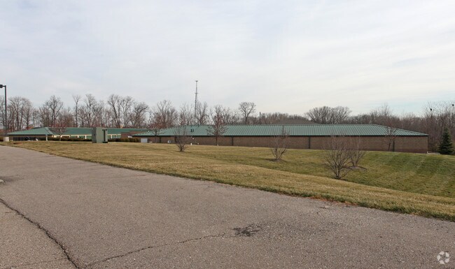
Property Detail
7058 Columbia Rd
Cincinnati, OH-KY-IN
COLUMBIA COMMONS RP LOT 6-A
16-22-220-002
Warren
Warehouse
Ohio
A Areas with a 1% annual chance of flooding and a 26% chance of flooding over the life of a 30-year mortgage.
6-a
2024
4.55 AC
2025
Mason/Montgomery
032003
Cincinnati/Dayton
65,225 SF
NEARBY LISTINGS FOR SALE OR LEASE
DEMOGRAPHICS near 7058 Columbia Rd
1 mile
3 mile
5 mile
2025 Total Population
4,589
58,777
148,025
2030 Population
4,801
61,497
153,998
Pop Growth 2025-2030
+ 4.62%
+ 4.63%
+ 4.04%
Average Age
41
41
40
2025 Total Households
1,950
23,098
55,107
HH Growth 2025-2030
+ 4.67%
+ 4.63%
+ 4.02%
Median Household Inc
$86,584
$117,482
$119,577
Avg Household Size
2.30
2.50
2.60
2025 Avg HH Vehicles
2.00
2.00
2.00
Median Home Value
$341,415
$397,878
$393,073
Median Year Built
1995
1994
1994
Nearby Places
Map Layers
Map Styles
 Street
 Aerial
Layers
 Traffic
 Biking
Places
Listings with unknown addresses are not visible on the map
- Restaurants
- Banks
- Shops
- Fitness
- Groceries
PUBLIC TRANSPORTATION
AIRPORT
Cincinnati/Northern Kentucky International
Drive
Walk
Distance
Cincinnati/Northern Kentucky International
57 min
37.3 mi
Freight Ports
Port of Toledo
Drive
Walk
Distance
Port of Toledo
224 min
190.0 mi
Nearby Properties
Address
Land Use
TOTAL SIZE
Lot Size
Zoning
Address
Land Use
TOTAL SIZE
Lot Size
Zoning
232.72 AC
Address
Land Use
TOTAL SIZE
Lot Size
Zoning
Address
Land Use
TOTAL SIZE
Lot Size
Zoning
Address
Land Use
TOTAL SIZE
Lot Size
Zoning
274,436 SF
27.12 AC
Address
Land Use
TOTAL SIZE
Lot Size
Zoning
590.28 AC
Address
Land Use
TOTAL SIZE
Lot Size
Zoning
219,265 SF
41.57 AC
Address
Land Use
TOTAL SIZE
Lot Size
Zoning
17,484 SF
35.55 AC
Address
Land Use
TOTAL SIZE
Lot Size
Zoning
80,767 SF
7.31 AC
Address
Land Use
TOTAL SIZE
Lot Size
Zoning
4,190 SF
36 AC
Address
Land Use
TOTAL SIZE
Lot Size
Zoning
47,424 SF
32.35 AC
Address
Land Use
TOTAL SIZE
Lot Size
Zoning
13,461 SF
47.72 AC
Address
Land Use
TOTAL SIZE
Lot Size
Zoning
102.64 AC
Address
Land Use
TOTAL SIZE
Lot Size
Zoning
42,906 SF
23.76 AC
Address
Land Use
TOTAL SIZE
Lot Size
Zoning
23.89 AC
Address
Land Use
TOTAL SIZE
Lot Size
Zoning
9,804 SF
40 AC
Address
Land Use
TOTAL SIZE
Lot Size
Zoning
121,429 SF
14.59 AC
Address
Land Use
TOTAL SIZE
Lot Size
Zoning
42,086 SF
8.17 AC
Address
Land Use
TOTAL SIZE
Lot Size
Zoning
40.92 AC
Address
Land Use
TOTAL SIZE
Lot Size
Zoning
45.96 AC
Address
Land Use
TOTAL SIZE
Lot Size
Zoning
294,645 SF
42.76 AC
Address
Land Use
TOTAL SIZE
Lot Size
Zoning
45,435 SF
22.94 AC
Address
Land Use
TOTAL SIZE
Lot Size
Zoning
85,759 SF
13.80 AC
Address
Land Use
TOTAL SIZE
Lot Size
Zoning
8,801 SF
29.24 AC
Address
Land Use
TOTAL SIZE
Lot Size
Zoning
35,188 SF
38.49 AC
Address
Land Use
TOTAL SIZE
Lot Size
Zoning
21.26 AC
Address
Land Use
TOTAL SIZE
Lot Size
Zoning
1,248 SF
21.67 AC
Address
Land Use
TOTAL SIZE
Lot Size
Zoning
1,600 SF
18.74 AC
Address
Land Use
TOTAL SIZE
Lot Size
Zoning
46,424 SF
11.61 AC
Address
Land Use
TOTAL SIZE
Lot Size
Zoning
13,532 SF
3.19 AC
Address
Land Use
TOTAL SIZE
Lot Size
Zoning
9,432 SF
40.41 AC
The World's #1 Commercial Real Estate Marketplace
Connect with us
© 2026 CoStar Group
The information above has been obtained from sources believed reliable. While we do not doubt its accuracy we have not verified it and make no guarantee, warranty or representation about it. It is your responsibility to independently confirm its accuracy and completeness. Any projections, opinions, assumptions, or estimates used are for example only and do not represent the current or future performance of the property. The value of this transaction to you depends on tax and other factors which should be evaluated by your tax, financial, and legal advisors. You and your advisors should conduct a careful, independent investigation of the property to determine to your satisfaction the suitability of the property for your needs.