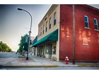
Property Record
704 Bank St Ne, Decatur, AL 35601

NEARBY LISTINGS FOR SALE OR LEASE
Property Detail
704 Bank St Ne
Decatur, AL
Decatur, City Of
03-04-18-1-032-002.000
FRAZIER & MONROE PROP ON BANK ST SW 47' OF NW 150' OF LOT 308 CITY OF DECATUR
Storebuilding
Morgan
X
Alabama
01083C0326F
308
2025
0.16 AC
2024
Downtown Decatur
000400
Other Market Areas
11,520 SF
DEMOGRAPHICS near 704 Bank St Ne
1 Mile
3 Mile
5 Mile
2024 Total Population
5,625
29,358
54,471
2029 Population
5,776
29,711
54,790
Pop Growth 2024-2029
+ 2.68%
+ 1.20%
+ 0.59%
Average Age
43
39
40
2024 Total Households
2,201
11,388
22,189
HH Growth 2024-2029
+ 2.86%
+ 1.26%
+ 0.58%
Median Household Inc
$36,488
$42,290
$48,030
Avg Household Size
2.00
2.40
2.30
2024 Avg HH Vehicles
2.00
2.00
2.00
Median Home Value
$115,070
$118,394
$149,651
Median Year Built
1957
1966
1976
Nearby Places
Map Layers
Map Styles
 Street
 Aerial
- Restaurants
- Banks
- Shops
- Fitness
- Groceries
PUBLIC TRANSPORTATION
AIRPORT
Huntsville International-Carl T Jones Field
DRIVE
WALK
Distance
Huntsville International-Carl T Jones Field
23 min
16.1 mi
Freight Ports
Port of Mobile
DRIVE
WALK
Distance
Port of Mobile
372 min
336.9 mi
SALE & LEASE HISTORY
LISTING DATE
SALE/LEASE

Nov 09, 2018
For Sale
Nearby Properties
Address
Land Use
TOTAL SIZE
Lot Size
Zoning
Address
Land Use
TOTAL SIZE
Lot Size
Zoning
176,476 SF
Address
Land Use
TOTAL SIZE
Lot Size
Zoning
121,551 SF
Address
Land Use
TOTAL SIZE
Lot Size
Zoning
90,249 SF
8 AC
Address
Land Use
TOTAL SIZE
Lot Size
Zoning
103,569 SF
6.69 AC
Address
Land Use
TOTAL SIZE
Lot Size
Zoning
7,812 SF
162 AC
Address
Land Use
TOTAL SIZE
Lot Size
Zoning
258,250 SF
55 AC
Address
Land Use
TOTAL SIZE
Lot Size
Zoning
15,331 SF
87 AC
Address
Land Use
TOTAL SIZE
Lot Size
Zoning
133,056 SF
6.29 AC
Address
Land Use
TOTAL SIZE
Lot Size
Zoning
132,156 SF
1.69 AC
Address
Land Use
TOTAL SIZE
Lot Size
Zoning
77,430 SF
19 AC
Address
Land Use
TOTAL SIZE
Lot Size
Zoning
48,364 SF
1.80 AC
Address
Land Use
TOTAL SIZE
Lot Size
Zoning
40,212 SF
1.21 AC
Address
Land Use
TOTAL SIZE
Lot Size
Zoning
54,544 SF
6.53 AC
Address
Land Use
TOTAL SIZE
Lot Size
Zoning
106,165 SF
0.80 AC
Address
Land Use
TOTAL SIZE
Lot Size
Zoning
100,632 SF
20 AC
Address
Land Use
TOTAL SIZE
Lot Size
Zoning
2,010 SF
20 AC
Address
Land Use
TOTAL SIZE
Lot Size
Zoning
220,128 SF
34 AC
Address
Land Use
TOTAL SIZE
Lot Size
Zoning
145,413 SF
2.30 AC
Address
Land Use
TOTAL SIZE
Lot Size
Zoning
2,546 SF
9.30 AC
Address
Land Use
TOTAL SIZE
Lot Size
Zoning
64,449 SF
12 AC
Address
Land Use
TOTAL SIZE
Lot Size
Zoning
4,865 SF
22 AC
Address
Land Use
TOTAL SIZE
Lot Size
Zoning
32,821 SF
1.68 AC
Address
Land Use
TOTAL SIZE
Lot Size
Zoning
49,384 SF
1.07 AC
Address
Land Use
TOTAL SIZE
Lot Size
Zoning
6.50 AC
Address
Land Use
TOTAL SIZE
Lot Size
Zoning
19,494 SF
3.30 AC
Address
Land Use
TOTAL SIZE
Lot Size
Zoning
146,160 SF
41.50 AC
Address
Land Use
TOTAL SIZE
Lot Size
Zoning
42,197 SF
3.75 AC
Address
Land Use
TOTAL SIZE
Lot Size
Zoning
53,680 SF
0.50 AC
Address
Land Use
TOTAL SIZE
Lot Size
Zoning
30,076 SF
4.46 AC
The World's #1 Commercial Real Estate Marketplace
Connect with us
© 2026 CoStar Group
The information above has been obtained from sources believed reliable. While we do not doubt its accuracy we have not verified it and make no guarantee, warranty or representation about it. It is your responsibility to independently confirm its accuracy and completeness. Any projections, opinions, assumptions, or estimates used are for example only and do not represent the current or future performance of the property. The value of this transaction to you depends on tax and other factors which should be evaluated by your tax, financial, and legal advisors. You and your advisors should conduct a careful, independent investigation of the property to determine to your satisfaction the suitability of the property for your needs.