Property Record
706 E Patton Ave, Montgomery, AL 36111
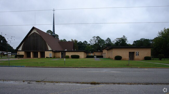

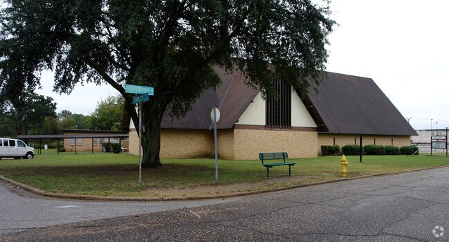
Property Detail
706 E Patton Ave
10-09-30-4-014-001.000
ALSO LOT 19 1009304014001000
Theater
Montgomery
R-100
Alabama
B and X Area of moderate flood hazard, usually the area between the limits of the 100-year and 500-year floods.
1
0
1.86 AC
2025
South Montgomery
002100
Montgomery
22,952 SF
Montgomery, AL
NEARBY LISTINGS FOR SALE OR LEASE
DEMOGRAPHICS near 706 E Patton Ave
1 mile
3 mile
5 mile
2025 Total Population
9,611
59,725
118,899
2030 Population
9,645
60,052
118,656
Pop Growth 2025-2030
+ 0.35%
+ 0.55%
(0.20%)
Average Age
39
39
38
2025 Total Households
3,694
23,927
48,758
HH Growth 2025-2030
+ 0.46%
+ 0.74%
(0.17%)
Median Household Inc
$51,978
$49,111
$48,918
Avg Household Size
2.50
2.30
2.30
2025 Avg HH Vehicles
2.00
2.00
2.00
Median Home Value
$90,236
$132,239
$133,064
Median Year Built
1959
1964
1971
Nearby Places
Map Layers
Map Styles
 Street
 Aerial
Layers
 Traffic
 Biking
Places
Listings with unknown addresses are not visible on the map
- Restaurants
- Banks
- Shops
- Fitness
- Groceries
PUBLIC TRANSPORTATION
AIRPORT
Montgomery Regional (Dannelly Field)
Drive
Walk
Distance
Montgomery Regional (Dannelly Field)
22 min
10.7 mi
Nearby Properties
Address
Land Use
TOTAL SIZE
Lot Size
Zoning
Address
Land Use
TOTAL SIZE
Lot Size
Zoning
150,842 SF
5.40 AC
T5
Address
Land Use
TOTAL SIZE
Lot Size
Zoning
260,402 SF
17 AC
O-2
Address
Land Use
TOTAL SIZE
Lot Size
Zoning
193,643 SF
1.61 AC
T5
Address
Land Use
TOTAL SIZE
Lot Size
Zoning
36,543 SF
0.62 AC
SD-M
Address
Land Use
TOTAL SIZE
Lot Size
Zoning
40,829 SF
50.49 AC
SD
Address
Land Use
TOTAL SIZE
Lot Size
Zoning
10,844 SF
1.63 AC
Address
Land Use
TOTAL SIZE
Lot Size
Zoning
93,981 SF
1.90 AC
T5
Address
Land Use
TOTAL SIZE
Lot Size
Zoning
164,528 SF
5.28 AC
B-3
Address
Land Use
TOTAL SIZE
Lot Size
Zoning
32,902 SF
14 AC
R-75-M
Address
Land Use
TOTAL SIZE
Lot Size
Zoning
8,519 SF
15.60 AC
B-2
Address
Land Use
TOTAL SIZE
Lot Size
Zoning
91,378 SF
2.46 AC
SD-M
Address
Land Use
TOTAL SIZE
Lot Size
Zoning
341,170 SF
O-2
Address
Land Use
TOTAL SIZE
Lot Size
Zoning
38,226 SF
5.77 AC
T5
Address
Land Use
TOTAL SIZE
Lot Size
Zoning
1.72 AC
T5
Address
Land Use
TOTAL SIZE
Lot Size
Zoning
14,733 SF
19 AC
O-2
Address
Land Use
TOTAL SIZE
Lot Size
Zoning
249,231 SF
20 AC
INST
Address
Land Use
TOTAL SIZE
Lot Size
Zoning
135,573 SF
35 AC
O-2
Address
Land Use
TOTAL SIZE
Lot Size
Zoning
1,721 SF
12.02 AC
R-60-M
Address
Land Use
TOTAL SIZE
Lot Size
Zoning
3,401 SF
3.21 AC
T5
Address
Land Use
TOTAL SIZE
Lot Size
Zoning
30,386 SF
10.12 AC
B-2
Address
Land Use
TOTAL SIZE
Lot Size
Zoning
1,904 SF
13 AC
R-75-S
Address
Land Use
TOTAL SIZE
Lot Size
Zoning
113,108 SF
3.70 AC
B-3
Address
Land Use
TOTAL SIZE
Lot Size
Zoning
65,060 SF
2.16 AC
T4-R
Address
Land Use
TOTAL SIZE
Lot Size
Zoning
2,115 SF
11.90 AC
R-65-M
Address
Land Use
TOTAL SIZE
Lot Size
Zoning
145,385 SF
3.31 AC
T4-0
Address
Land Use
TOTAL SIZE
Lot Size
Zoning
8,028 SF
12.50 AC
R-65-M
Address
Land Use
TOTAL SIZE
Lot Size
Zoning
61,137 SF
59 AC
INST
Address
Land Use
TOTAL SIZE
Lot Size
Zoning
57,565 SF
1.50 AC
T4-R
Address
Land Use
TOTAL SIZE
Lot Size
Zoning
95,886 SF
3.19 AC
B-4
Address
Land Use
TOTAL SIZE
Lot Size
Zoning
54,384 SF
0.65 AC
The World's #1 Commercial Real Estate Marketplace
Connect with us
© 2026 CoStar Group
The information above has been obtained from sources believed reliable. While we do not doubt its accuracy we have not verified it and make no guarantee, warranty or representation about it. It is your responsibility to independently confirm its accuracy and completeness. Any projections, opinions, assumptions, or estimates used are for example only and do not represent the current or future performance of the property. The value of this transaction to you depends on tax and other factors which should be evaluated by your tax, financial, and legal advisors. You and your advisors should conduct a careful, independent investigation of the property to determine to your satisfaction the suitability of the property for your needs.