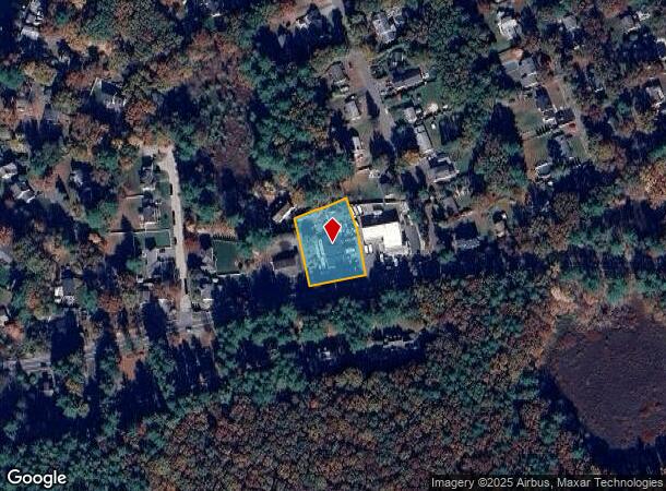
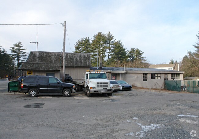
Property Record
706 Main St, Hudson, MA 01749

NEARBY LISTINGS FOR SALE OR LEASE
Property Detail
706 Main St
HUDS-000036-000000-000040
Middlesex
Autorepair
Massachusetts
X
40
25017C0363F
0.67 AC
2025
Concord/Maynard
2025
Boston
322100
Boston-Cambridge-Newton, MA-NH
3,990 SF
DEMOGRAPHICS near 706 Main St
1 Mile
3 Mile
5 Mile
2024 Total Population
1,696
22,026
94,285
2029 Population
1,682
21,934
93,307
Pop Growth 2024-2029
(0.83%)
(0.42%)
(1.04%)
Average Age
44
43
42
2024 Total Households
651
8,091
36,718
HH Growth 2024-2029
(0.92%)
(0.43%)
(1.14%)
Median Household Inc
$166,822
$152,000
$114,044
Avg Household Size
2.60
2.70
2.50
2024 Avg HH Vehicles
2.00
2.00
2.00
Median Home Value
$760,075
$634,741
$536,949
Median Year Built
1986
1979
1971
Nearby Places
Map Layers
Map Styles
 Street
 Aerial
- Restaurants
- Banks
- Shops
- Fitness
- Groceries
PUBLIC TRANSPORTATION
COMMUTER RAIL
South Acton (Fitchburg/South Acton Line - Massachusetts Bay Transportation Authority Commuter Rail (Purple Line))
DRIVE
WALK
Distance
South Acton (Fitchburg/South Acton Line - Massachusetts Bay Transportation Authority Commuter Rail (Purple Line))
18 min
8.3 mi
West Concord (Fitchburg/South Acton Line - Massachusetts Bay Transportation Authority Commuter Rail (Purple Line))
DRIVE
WALK
Distance
West Concord (Fitchburg/South Acton Line - Massachusetts Bay Transportation Authority Commuter Rail (Purple Line))
20 min
9.6 mi
AIRPORT
Worcester Regional
DRIVE
WALK
Distance
Worcester Regional
42 min
25.2 mi
General Edward Lawrence Logan International
DRIVE
WALK
Distance
General Edward Lawrence Logan International
49 min
29.8 mi
Freight Ports
Port of Boston
DRIVE
WALK
Distance
Port of Boston
47 min
28.1 mi
Nearby Properties
Address
Land Use
TOTAL SIZE
Lot Size
Zoning
Address
Land Use
TOTAL SIZE
Lot Size
Zoning
160 SF
R1
Address
Land Use
TOTAL SIZE
Lot Size
Zoning
22.74 AC
A1
Address
Land Use
TOTAL SIZE
Lot Size
Zoning
326,464 SF
19.52 AC
I
Address
Land Use
TOTAL SIZE
Lot Size
Zoning
51,504 SF
18.87 AC
C
Address
Land Use
TOTAL SIZE
Lot Size
Zoning
85,958 SF
13.52 AC
A3
Address
Land Use
TOTAL SIZE
Lot Size
Zoning
46.82 AC
RC
Address
Land Use
TOTAL SIZE
Lot Size
Zoning
155,339 SF
24 AC
R1
Address
Land Use
TOTAL SIZE
Lot Size
Zoning
16.84 AC
M5
Address
Land Use
TOTAL SIZE
Lot Size
Zoning
71.89 AC
RR
Address
Land Use
TOTAL SIZE
Lot Size
Zoning
815 AC
OS
Address
Land Use
TOTAL SIZE
Lot Size
Zoning
13.19 AC
B
Address
Land Use
TOTAL SIZE
Lot Size
Zoning
990.40 AC
RC
Address
Land Use
TOTAL SIZE
Lot Size
Zoning
122.98 AC
SA8
Address
Land Use
TOTAL SIZE
Lot Size
Zoning
159,720 SF
16.05 AC
M6
Address
Land Use
TOTAL SIZE
Lot Size
Zoning
28.09 AC
R
Address
Land Use
TOTAL SIZE
Lot Size
Zoning
85,000 SF
18.77 AC
R1
Address
Land Use
TOTAL SIZE
Lot Size
Zoning
65.15 AC
WI
Address
Land Use
TOTAL SIZE
Lot Size
Zoning
12.30 AC
B
Address
Land Use
TOTAL SIZE
Lot Size
Zoning
60,290 SF
20.50 AC
SA8
Address
Land Use
TOTAL SIZE
Lot Size
Zoning
71,873 SF
22.53 AC
RR
Address
Land Use
TOTAL SIZE
Lot Size
Zoning
5.78 AC
B
Address
Land Use
TOTAL SIZE
Lot Size
Zoning
80,494 SF
5.12 AC
M4
Address
Land Use
TOTAL SIZE
Lot Size
Zoning
40,928 SF
28.46 AC
M5
Address
Land Use
TOTAL SIZE
Lot Size
Zoning
106,778 SF
8.58 AC
M6
Address
Land Use
TOTAL SIZE
Lot Size
Zoning
208.81 AC
M6
Address
Land Use
TOTAL SIZE
Lot Size
Zoning
217 AC
WI
Address
Land Use
TOTAL SIZE
Lot Size
Zoning
14,806 SF
9.53 AC
A1
Address
Land Use
TOTAL SIZE
Lot Size
Zoning
20.74 AC
R
Address
Land Use
TOTAL SIZE
Lot Size
Zoning
262.92 AC
OSD
Address
Land Use
TOTAL SIZE
Lot Size
Zoning
42,500 SF
8.08 AC
M5
The World's #1 Commercial Real Estate Marketplace
Connect with us
© 2026 CoStar Group
The information above has been obtained from sources believed reliable. While we do not doubt its accuracy we have not verified it and make no guarantee, warranty or representation about it. It is your responsibility to independently confirm its accuracy and completeness. Any projections, opinions, assumptions, or estimates used are for example only and do not represent the current or future performance of the property. The value of this transaction to you depends on tax and other factors which should be evaluated by your tax, financial, and legal advisors. You and your advisors should conduct a careful, independent investigation of the property to determine to your satisfaction the suitability of the property for your needs.