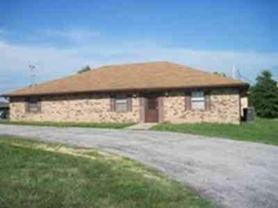
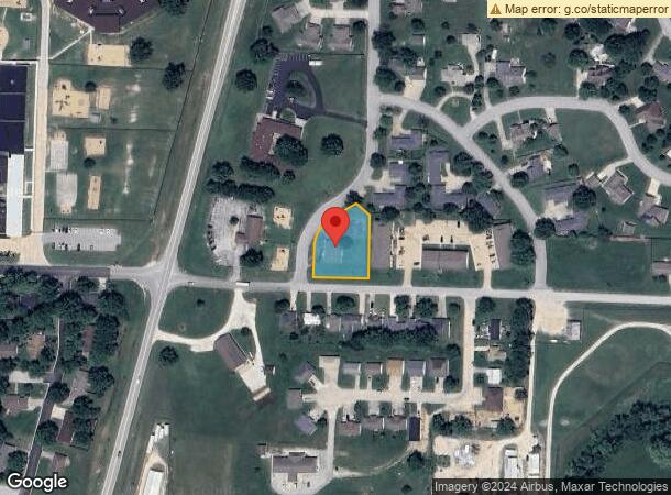
Property Record
706 N Briarwood Dr, Bolivar, MO 65613

NEARBY LISTINGS FOR SALE OR LEASE
-
-
View all Bolivar listings for sale on LoopNet.com
Property Detail
706 N Briarwood Dr
Springfield, MO
Briarwood
8910030600200100600
BOLIVAR - BRIARWOOD SUB - LOT 1 LESS TRIANGLE SHAPE IN NW CRN
Daycare
Polk
X
Missouri
29167C0282D
1
0
0.63 AC
2024
Polk County
960202
Springfield
2,400 SF
DEMOGRAPHICS near 706 N Briarwood Dr
1 Mile
3 Mile
5 Mile
2024 Total Population
2,621
13,029
15,675
2029 Population
2,859
14,199
17,093
Pop Growth 2024-2029
+ 9.08%
+ 8.98%
+ 9.05%
Average Age
39
38
39
2024 Total Households
1,039
5,001
6,000
HH Growth 2024-2029
+ 9.34%
+ 9.20%
+ 9.27%
Median Household Inc
$33,542
$42,000
$43,898
Avg Household Size
2.40
2.40
2.40
2024 Avg HH Vehicles
2.00
2.00
2.00
Median Home Value
$150,348
$159,446
$161,037
Median Year Built
1981
1984
1985
Nearby Places
Map Layers
Map Styles
 Street
 Aerial
- Restaurants
- Banks
- Shops
- Fitness
- Groceries
PUBLIC TRANSPORTATION
AIRPORT
Springfield-Branson Ntl
DRIVE
WALK
Distance
Springfield-Branson Ntl
52 min
35.9 mi
Nearby Properties
Address
Land Use
TOTAL SIZE
Lot Size
Zoning
Address
Land Use
TOTAL SIZE
Lot Size
Zoning
51,549 SF
11.02 AC
Address
Land Use
TOTAL SIZE
Lot Size
Zoning
768 SF
10.88 AC
Address
Land Use
TOTAL SIZE
Lot Size
Zoning
127,417 SF
34.74 AC
Address
Land Use
TOTAL SIZE
Lot Size
Zoning
7,796 SF
10.88 AC
Address
Land Use
TOTAL SIZE
Lot Size
Zoning
6,000 SF
4.25 AC
Address
Land Use
TOTAL SIZE
Lot Size
Zoning
14,216 SF
2.79 AC
Address
Land Use
TOTAL SIZE
Lot Size
Zoning
1,866 SF
3.13 AC
Address
Land Use
TOTAL SIZE
Lot Size
Zoning
9,000 SF
4.44 AC
Address
Land Use
TOTAL SIZE
Lot Size
Zoning
20,233 SF
2.10 AC
Address
Land Use
TOTAL SIZE
Lot Size
Zoning
10,848 SF
1.77 AC
Address
Land Use
TOTAL SIZE
Lot Size
Zoning
12,116 SF
3.50 AC
Address
Land Use
TOTAL SIZE
Lot Size
Zoning
11,394 SF
14.21 AC
Address
Land Use
TOTAL SIZE
Lot Size
Zoning
7,523 SF
1.14 AC
Address
Land Use
TOTAL SIZE
Lot Size
Zoning
12,380 SF
1.86 AC
Address
Land Use
TOTAL SIZE
Lot Size
Zoning
6,893 SF
3.15 AC
Address
Land Use
TOTAL SIZE
Lot Size
Zoning
12,960 SF
1.39 AC
Address
Land Use
TOTAL SIZE
Lot Size
Zoning
5,760 SF
4.10 AC
Address
Land Use
TOTAL SIZE
Lot Size
Zoning
18,210 SF
1.86 AC
Address
Land Use
TOTAL SIZE
Lot Size
Zoning
20,944 SF
3.19 AC
Address
Land Use
TOTAL SIZE
Lot Size
Zoning
8,045 SF
1.54 AC
Address
Land Use
TOTAL SIZE
Lot Size
Zoning
800 SF
4.41 AC
Address
Land Use
TOTAL SIZE
Lot Size
Zoning
17,003 SF
0.83 AC
Address
Land Use
TOTAL SIZE
Lot Size
Zoning
10,130 SF
1.24 AC
Address
Land Use
TOTAL SIZE
Lot Size
Zoning
2,400 SF
2.26 AC
Address
Land Use
TOTAL SIZE
Lot Size
Zoning
23,100 SF
2.86 AC
Address
Land Use
TOTAL SIZE
Lot Size
Zoning
13,628 SF
1.68 AC
Address
Land Use
TOTAL SIZE
Lot Size
Zoning
4,923 SF
1.50 AC
Address
Land Use
TOTAL SIZE
Lot Size
Zoning
1,480 SF
4 AC
The World's #1 Commercial Real Estate Marketplace
Connect with us
© 2026 CoStar Group
The information above has been obtained from sources believed reliable. While we do not doubt its accuracy we have not verified it and make no guarantee, warranty or representation about it. It is your responsibility to independently confirm its accuracy and completeness. Any projections, opinions, assumptions, or estimates used are for example only and do not represent the current or future performance of the property. The value of this transaction to you depends on tax and other factors which should be evaluated by your tax, financial, and legal advisors. You and your advisors should conduct a careful, independent investigation of the property to determine to your satisfaction the suitability of the property for your needs.