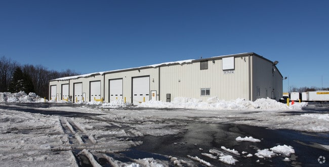
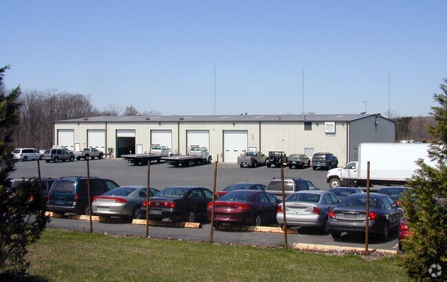
Property Record
706 Philadelphia Rd, Joppa, MD 21085

NEARBY LISTINGS FOR SALE OR LEASE
Property Detail
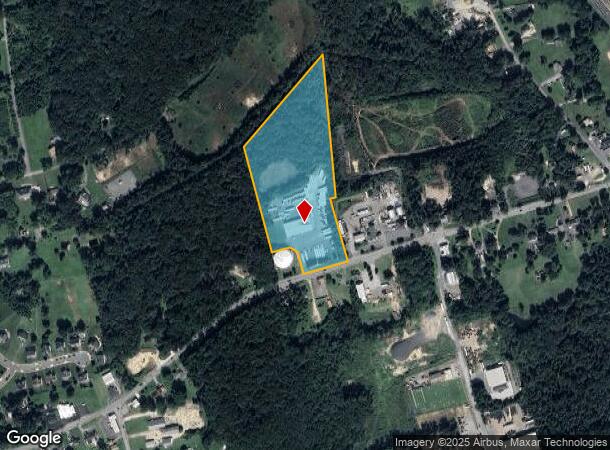
706 Philadelphia Rd
Baltimore-Columbia-Towson, MD
Amoss Wm
01-220462
LT 1 11.437 AC 706 PHILADELPHIA ROAD LD WM AMOSS PT 82/23
Warehouse
Harford
X
Maryland
2400100315H
1
2025
11.43 AC
2025
Outlying Harford Cnty
301301
Baltimore
12,800 SF
DEMOGRAPHICS near 706 Philadelphia Rd
1 Mile
3 Mile
5 Mile
2024 Total Population
2,758
39,201
99,168
2029 Population
2,832
40,250
101,265
Pop Growth 2024-2029
+ 2.68%
+ 2.68%
+ 2.11%
Average Age
42
39
40
2024 Total Households
985
14,882
36,821
HH Growth 2024-2029
+ 2.64%
+ 2.71%
+ 2.14%
Median Household Inc
$103,000
$80,565
$93,919
Avg Household Size
2.70
2.60
2.60
2024 Avg HH Vehicles
2.00
2.00
2.00
Median Home Value
$345,547
$253,870
$306,983
Median Year Built
1987
1981
1986
Nearby Places
Map Layers
Map Styles
 Street
 Aerial
- Restaurants
- Banks
- Shops
- Fitness
- Groceries
PUBLIC TRANSPORTATION
COMMUTER RAIL
Edgewood (PENN - WASHINGTON - Maryland Area Regional Commuter Trains (The MARC), Penn Line - Maryland Area Regional Commuter Trains (The MARC))
DRIVE
WALK
Distance
Edgewood (PENN - WASHINGTON - Maryland Area Regional Commuter Trains (The MARC), Penn Line - Maryland Area Regional Commuter Trains (The MARC))
10 min
4.7 mi
AIRPORT
Baltimore/Washington International Thurgood Marshall
DRIVE
WALK
Distance
Baltimore/Washington International Thurgood Marshall
44 min
30.5 mi
Freight Ports
Port of Baltimore
DRIVE
WALK
Distance
Port of Baltimore
31 min
21.8 mi
Nearby Properties
Address
Land Use
TOTAL SIZE
Lot Size
Zoning
Address
Land Use
TOTAL SIZE
Lot Size
Zoning
5,501.68 AC
R1
Address
Land Use
TOTAL SIZE
Lot Size
Zoning
253,842 SF
69.33 AC
R2
Address
Land Use
TOTAL SIZE
Lot Size
Zoning
44,475 SF
86.10 AC
R2
Address
Land Use
TOTAL SIZE
Lot Size
Zoning
822,410 SF
44.24 AC
GI
Address
Land Use
TOTAL SIZE
Lot Size
Zoning
996,030 SF
70.22 AC
GI
Address
Land Use
TOTAL SIZE
Lot Size
Zoning
212,760 SF
27.85 AC
GI
Address
Land Use
TOTAL SIZE
Lot Size
Zoning
246,560 SF
14.57 AC
LI
Address
Land Use
TOTAL SIZE
Lot Size
Zoning
61,350 SF
20 AC
B2
Address
Land Use
TOTAL SIZE
Lot Size
Zoning
124,268 SF
10.85 AC
R3
Address
Land Use
TOTAL SIZE
Lot Size
Zoning
1,690 SF
76.45 AC
R4
Address
Land Use
TOTAL SIZE
Lot Size
Zoning
109,398 SF
11.36 AC
CI
Address
Land Use
TOTAL SIZE
Lot Size
Zoning
200 AC
R4
Address
Land Use
TOTAL SIZE
Lot Size
Zoning
134,875 SF
40.88 AC
CI
Address
Land Use
TOTAL SIZE
Lot Size
Zoning
113,173 SF
17.04 AC
CI
Address
Land Use
TOTAL SIZE
Lot Size
Zoning
94,312 SF
14.40 AC
LI
Address
Land Use
TOTAL SIZE
Lot Size
Zoning
18.51 AC
R3
Address
Land Use
TOTAL SIZE
Lot Size
Zoning
255,464 SF
19.15 AC
GI
Address
Land Use
TOTAL SIZE
Lot Size
Zoning
16,129 SF
58.25 AC
AG
Address
Land Use
TOTAL SIZE
Lot Size
Zoning
142,311 SF
24.28 AC
GI
Address
Land Use
TOTAL SIZE
Lot Size
Zoning
150 AC
R4
Address
Land Use
TOTAL SIZE
Lot Size
Zoning
150 AC
R4
Address
Land Use
TOTAL SIZE
Lot Size
Zoning
97,454 SF
14.72 AC
L1
Address
Land Use
TOTAL SIZE
Lot Size
Zoning
67,184 SF
8.51 AC
GI
Address
Land Use
TOTAL SIZE
Lot Size
Zoning
130,200 SF
10.03 AC
LI
Address
Land Use
TOTAL SIZE
Lot Size
Zoning
28,452 SF
6 AC
R4
Address
Land Use
TOTAL SIZE
Lot Size
Zoning
5,700 SF
8.68 AC
CI
Address
Land Use
TOTAL SIZE
Lot Size
Zoning
100,950 SF
7.26 AC
R4
Address
Land Use
TOTAL SIZE
Lot Size
Zoning
77,438 SF
6.40 AC
GI
Address
Land Use
TOTAL SIZE
Lot Size
Zoning
116,084 SF
13.52 AC
CI
Address
Land Use
TOTAL SIZE
Lot Size
Zoning
105,760 SF
5.23 AC
GI
The World's #1 Commercial Real Estate Marketplace
Connect with us
© 2026 CoStar Group
The information above has been obtained from sources believed reliable. While we do not doubt its accuracy we have not verified it and make no guarantee, warranty or representation about it. It is your responsibility to independently confirm its accuracy and completeness. Any projections, opinions, assumptions, or estimates used are for example only and do not represent the current or future performance of the property. The value of this transaction to you depends on tax and other factors which should be evaluated by your tax, financial, and legal advisors. You and your advisors should conduct a careful, independent investigation of the property to determine to your satisfaction the suitability of the property for your needs.