Property Record
706 Roberta Dr, Rossville, GA 30741

Save to a Folder
{{folder.Name}}
{{folder.ListingIds.length}} Properties
{{folder.ListingIds.length}} Property
Create a New Folder
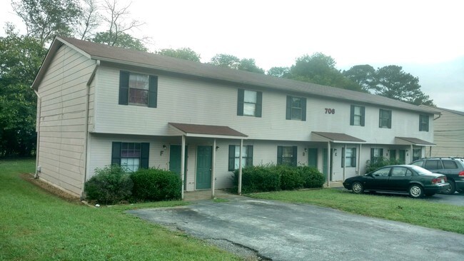
Property Detail
706 Roberta Dr
0117-239
PT LL 10 9/4
Commercialnec
Walker
R2
Georgia
B and X Area of moderate flood hazard, usually the area between the limits of the 100-year and 500-year floods.
1.03 AC
2025
Rossville
2025
Chattanooga
020101
Chattanooga, TN-GA
5,460 SF
NEARBY LISTINGS FOR SALE OR LEASE
-
-
-
No Photo
-
View all Rossville listings for sale on LoopNet.com
DEMOGRAPHICS near 706 Roberta Dr
1 mile
3 mile
5 mile
2025 Total Population
4,006
34,942
91,298
2030 Population
4,057
36,177
94,615
Pop Growth 2025-2030
+ 1.27%
+ 3.53%
+ 3.63%
Average Age
40
39
39
2025 Total Households
1,577
13,519
36,457
HH Growth 2025-2030
+ 1.33%
+ 3.53%
+ 3.72%
Median Household Inc
$40,636
$55,780
$56,684
Avg Household Size
2.50
2.50
2.40
2025 Avg HH Vehicles
2.00
2.00
2.00
Median Home Value
$186,298
$204,190
$225,063
Median Year Built
1971
1961
1966
Nearby Places
Map Layers
Map Styles
 Street
 Aerial
Layers
 Traffic
 Biking
Places
Listings with unknown addresses are not visible on the map
- Restaurants
- Banks
- Shops
- Fitness
- Groceries
PUBLIC TRANSPORTATION
AIRPORT
Lovell Field
Drive
Walk
Distance
Lovell Field
25 min
9.5 mi
SALE & LEASE HISTORY
LISTING DATE
SALE/LEASE

Oct 06, 2018
For Sale
May 31, 2018
For Sale
Nearby Properties
Address
Land Use
TOTAL SIZE
Lot Size
Zoning
Address
Land Use
TOTAL SIZE
Lot Size
Zoning
296,016 SF
13.36 AC
R3
Address
Land Use
TOTAL SIZE
Lot Size
Zoning
54,026 SF
17.89 AC
FOR R-3
Address
Land Use
TOTAL SIZE
Lot Size
Zoning
1.61 AC
R2
Address
Land Use
TOTAL SIZE
Lot Size
Zoning
458,265 SF
62.80 AC
M1
Address
Land Use
TOTAL SIZE
Lot Size
Zoning
32,472 SF
17.50 AC
C1
Address
Land Use
TOTAL SIZE
Lot Size
Zoning
184,050 SF
43.42 AC
C1
Address
Land Use
TOTAL SIZE
Lot Size
Zoning
111,056 SF
9.89 AC
R4
Address
Land Use
TOTAL SIZE
Lot Size
Zoning
65,289 SF
7.05 AC
A1
Address
Land Use
TOTAL SIZE
Lot Size
Zoning
298,470 SF
15.03 AC
M1
Address
Land Use
TOTAL SIZE
Lot Size
Zoning
296,859 SF
10.42 AC
M1
Address
Land Use
TOTAL SIZE
Lot Size
Zoning
65,497 SF
8.48 AC
R2
Address
Land Use
TOTAL SIZE
Lot Size
Zoning
242,000 SF
12.05 AC
M1
Address
Land Use
TOTAL SIZE
Lot Size
Zoning
61,370 SF
10.16 AC
I
Address
Land Use
TOTAL SIZE
Lot Size
Zoning
656 SF
7.14 AC
R4
Address
Land Use
TOTAL SIZE
Lot Size
Zoning
4.80 AC
R2
Address
Land Use
TOTAL SIZE
Lot Size
Zoning
16,790 SF
1.15 AC
R2
Address
Land Use
TOTAL SIZE
Lot Size
Zoning
65,455 SF
11.25 AC
R3
Address
Land Use
TOTAL SIZE
Lot Size
Zoning
174,965 SF
7.20 AC
Address
Land Use
TOTAL SIZE
Lot Size
Zoning
38,575 SF
9.07 AC
M1
Address
Land Use
TOTAL SIZE
Lot Size
Zoning
146,834 SF
7.38 AC
M1
Address
Land Use
TOTAL SIZE
Lot Size
Zoning
14,457 SF
2.06 AC
C2
Address
Land Use
TOTAL SIZE
Lot Size
Zoning
3.80 AC
R2
Address
Land Use
TOTAL SIZE
Lot Size
Zoning
27,664 SF
252.56 AC
I
Address
Land Use
TOTAL SIZE
Lot Size
Zoning
4,800 SF
3.06 AC
I
Address
Land Use
TOTAL SIZE
Lot Size
Zoning
3.55 AC
R2
Address
Land Use
TOTAL SIZE
Lot Size
Zoning
11,784 SF
1.09 AC
C2
Address
Land Use
TOTAL SIZE
Lot Size
Zoning
105,000 SF
4.10 AC
M1
Address
Land Use
TOTAL SIZE
Lot Size
Zoning
116,875 SF
12.18 AC
FOR C-2
Address
Land Use
TOTAL SIZE
Lot Size
Zoning
60,325 SF
2.90 AC
M1
Address
Land Use
TOTAL SIZE
Lot Size
Zoning
100,000 SF
3.90 AC
The World's #1 Commercial Real Estate Marketplace
Connect with us
© 2026 CoStar Group
The information above has been obtained from sources believed reliable. While we do not doubt its accuracy we have not verified it and make no guarantee, warranty or representation about it. It is your responsibility to independently confirm its accuracy and completeness. Any projections, opinions, assumptions, or estimates used are for example only and do not represent the current or future performance of the property. The value of this transaction to you depends on tax and other factors which should be evaluated by your tax, financial, and legal advisors. You and your advisors should conduct a careful, independent investigation of the property to determine to your satisfaction the suitability of the property for your needs.