Property Record
7063 W 48Th St, Fremont, MI 49412
NEARBY LISTINGS FOR SALE OR LEASE
-
-
View all Fremont listings for sale on LoopNet.com
Property Detail
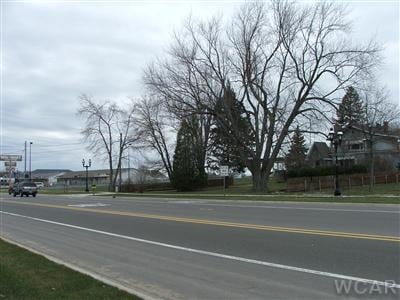
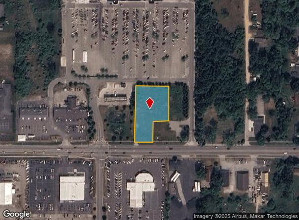
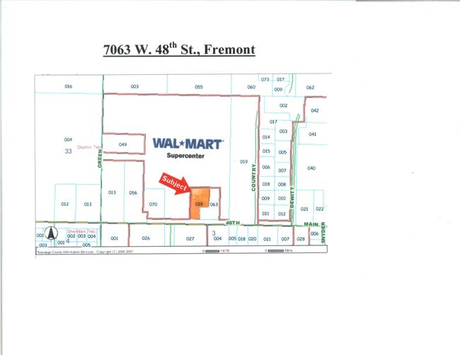
7063 W 48Th St
13-34-300-019
COM 264 FT E & 47.35 FT N OF SW COR E 1/2 SW 1/4 SW 1/4 TH N 330 FT E 199 FT S 200 FT W 95 FT S 130 FT W 104 FT TO BEG SEC.
Commercialacreage
Newaygo
X
Michigan
26123C0403D
1.22 AC
2024
Newaygo County
2025
West Michigan
970500
DEMOGRAPHICS near 7063 W 48Th St
1 Mile
3 Mile
5 Mile
2024 Total Population
1,859
6,445
8,676
2029 Population
1,921
6,626
8,893
Pop Growth 2024-2029
+ 3.34%
+ 2.81%
+ 2.50%
Average Age
42
41
41
2024 Total Households
816
2,642
3,412
HH Growth 2024-2029
+ 3.06%
+ 2.61%
+ 2.34%
Median Household Inc
$52,666
$57,235
$58,481
Avg Household Size
2.20
2.30
2.40
2024 Avg HH Vehicles
2.00
2.00
2.00
Median Home Value
$96,632
$144,746
$151,426
Median Year Built
1971
1966
1969
Nearby Places
- Restaurants
- Banks
- Shops
- Fitness
- Groceries
SALE & LEASE HISTORY
LISTING DATE
SALE/LEASE

Jan 10, 2017
For Sale
Nearby Properties
Address
Land Use
TOTAL SIZE
Lot Size
Zoning
Address
Land Use
TOTAL SIZE
Lot Size
Zoning
945,070 SF
41 AC
LOCAL ZONE
Address
Land Use
TOTAL SIZE
Lot Size
Zoning
317,362 SF
27 AC
LOCAL ZONE
Address
Land Use
TOTAL SIZE
Lot Size
Zoning
28.72 AC
LOCAL ZONE
Address
Land Use
TOTAL SIZE
Lot Size
Zoning
186,060 SF
27.05 AC
LOCAL ZONE
Address
Land Use
TOTAL SIZE
Lot Size
Zoning
171,381 SF
13.45 AC
LOCAL ZONE
Address
Land Use
TOTAL SIZE
Lot Size
Zoning
Address
Land Use
TOTAL SIZE
Lot Size
Zoning
7.61 AC
LOCAL ZONE
Address
Land Use
TOTAL SIZE
Lot Size
Zoning
19,952 SF
4.23 AC
R1
Address
Land Use
TOTAL SIZE
Lot Size
Zoning
25,168 SF
5.29 AC
LOCAL ZONE
Address
Land Use
TOTAL SIZE
Lot Size
Zoning
46,376 SF
4.57 AC
LOCAL ZONE
Address
Land Use
TOTAL SIZE
Lot Size
Zoning
4.75 AC
LOCAL ZONE
Address
Land Use
TOTAL SIZE
Lot Size
Zoning
19,216 SF
4.35 AC
LOCAL ZONE
Address
Land Use
TOTAL SIZE
Lot Size
Zoning
16 AC
LOCAL ZONE
Address
Land Use
TOTAL SIZE
Lot Size
Zoning
Address
Land Use
TOTAL SIZE
Lot Size
Zoning
32,036 SF
4.36 AC
LOCAL ZONE
Address
Land Use
TOTAL SIZE
Lot Size
Zoning
28,231 SF
5.22 AC
LOCAL ZONE
Address
Land Use
TOTAL SIZE
Lot Size
Zoning
3,520 SF
30 AC
LOCAL ZONE
Address
Land Use
TOTAL SIZE
Lot Size
Zoning
7.60 AC
LOCAL ZONE
Address
Land Use
TOTAL SIZE
Lot Size
Zoning
38,516 SF
2.58 AC
LOCAL ZONE
Address
Land Use
TOTAL SIZE
Lot Size
Zoning
40,780 SF
4.05 AC
LOCAL ZONE
Address
Land Use
TOTAL SIZE
Lot Size
Zoning
13,566 SF
2.21 AC
LOCAL ZONE
Address
Land Use
TOTAL SIZE
Lot Size
Zoning
13,671 SF
1.33 AC
LOCAL ZONE
Address
Land Use
TOTAL SIZE
Lot Size
Zoning
76,600 SF
16.70 AC
LOCAL ZONE
Address
Land Use
TOTAL SIZE
Lot Size
Zoning
1.30 AC
LOCAL ZONE
Address
Land Use
TOTAL SIZE
Lot Size
Zoning
11,672 SF
3.58 AC
LOCAL ZONE
Address
Land Use
TOTAL SIZE
Lot Size
Zoning
6,304 SF
2.80 AC
R1
Address
Land Use
TOTAL SIZE
Lot Size
Zoning
3.31 AC
LOCAL ZONE
Address
Land Use
TOTAL SIZE
Lot Size
Zoning
8,394 SF
86.20 AC
LOCAL ZONE
Address
Land Use
TOTAL SIZE
Lot Size
Zoning
1.16 AC
LOCAL ZONE
Address
Land Use
TOTAL SIZE
Lot Size
Zoning
9,731 SF
1.15 AC
LOCAL ZONE
The World's #1 Commercial Real Estate Marketplace
Connect with us
© 2025 CoStar Group
The information above has been obtained from sources believed reliable. While we do not doubt its accuracy we have not verified it and make no guarantee, warranty or representation about it. It is your responsibility to independently confirm its accuracy and completeness. Any projections, opinions, assumptions, or estimates used are for example only and do not represent the current or future performance of the property. The value of this transaction to you depends on tax and other factors which should be evaluated by your tax, financial, and legal advisors. You and your advisors should conduct a careful, independent investigation of the property to determine to your satisfaction the suitability of the property for your needs.