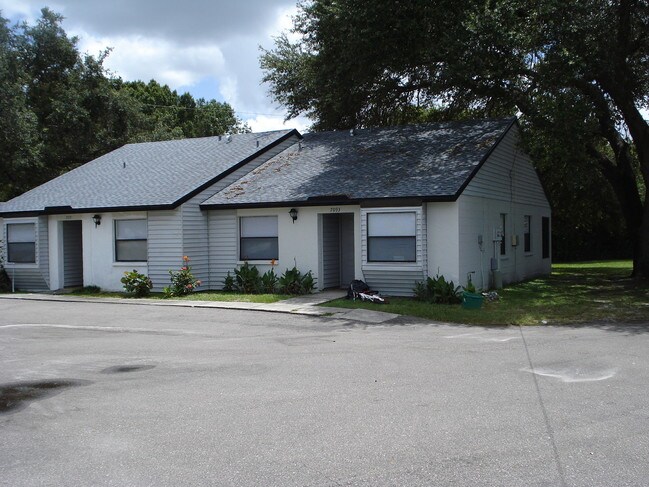
Property Record
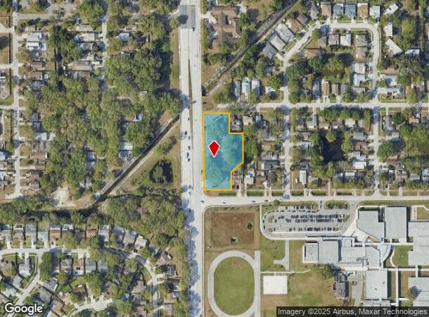
7065 71St St N, Pinellas Park, FL 33781

NEARBY LISTINGS FOR SALE OR LEASE
Property Detail
7065 71St St N
Tampa-St. Petersburg-Clearwater, FL
Pinellas Park 2Nd Add
30-30-16-71100-113-0110
PINELLAS PARK 2ND ADD BLK 113, LOTS 12, 13 & 14 & W 1/2 OF VAC ALLEY ON E & PT OF LOTS 9, 10, 11, 15 & 16 ALL DESC FROM SW COR OF LOT 9 TH N01DW 10FT FOR POB TH N01DW 372.4FT TH E 128.4FT TH S01DE 95FT TH E 66.8FT TH S01DE 142.5FT TH S51DW 76FT TH S0
Apartment
Pinellas
AE
Florida
12103C0203J
9
2024
1.36 AC
2025
Northside
025014
Tampa/St Petersburg
9,514 SF
DEMOGRAPHICS near 7065 71St St N
1 Mile
3 Mile
5 Mile
2024 Total Population
12,877
102,704
256,442
2029 Population
12,867
102,788
257,269
Pop Growth 2024-2029
(0.08%)
+ 0.08%
+ 0.32%
Average Age
43
45
46
2024 Total Households
5,102
43,875
115,799
HH Growth 2024-2029
(0.43%)
(0.07%)
+ 0.30%
Median Household Inc
$59,334
$57,566
$58,882
Avg Household Size
2.40
2.20
2.10
2024 Avg HH Vehicles
2.00
2.00
2.00
Median Home Value
$252,556
$232,687
$239,873
Median Year Built
1978
1973
1973
Nearby Places
Map Layers
Map Styles
 Street
 Aerial
- Restaurants
- Banks
- Shops
- Fitness
- Groceries
PUBLIC TRANSPORTATION
AIRPORT
St Pete-Clearwater International
DRIVE
WALK
Distance
St Pete-Clearwater International
21 min
9.8 mi
Tampa International
DRIVE
WALK
Distance
Tampa International
31 min
20.0 mi
Freight Ports
Port Manatee
DRIVE
WALK
Distance
Port Manatee
46 min
33.4 mi
Nearby Properties
Address
Land Use
TOTAL SIZE
Lot Size
Zoning
Address
Land Use
TOTAL SIZE
Lot Size
Zoning
459,848 SF
19.74 AC
R6
Address
Land Use
TOTAL SIZE
Lot Size
Zoning
372,013 SF
10.10 AC
Address
Land Use
TOTAL SIZE
Lot Size
Zoning
738,882 SF
43.34 AC
Address
Land Use
TOTAL SIZE
Lot Size
Zoning
328,466 SF
18.81 AC
Address
Land Use
TOTAL SIZE
Lot Size
Zoning
358,681 SF
11.70 AC
Address
Land Use
TOTAL SIZE
Lot Size
Zoning
227,858 SF
64.31 AC
AE
Address
Land Use
TOTAL SIZE
Lot Size
Zoning
206,685 SF
16.75 AC
RPD5
Address
Land Use
TOTAL SIZE
Lot Size
Zoning
267,649 SF
17.86 AC
Address
Land Use
TOTAL SIZE
Lot Size
Zoning
582,271 SF
17.14 AC
Address
Land Use
TOTAL SIZE
Lot Size
Zoning
10,474 SF
660.47 AC
R3
Address
Land Use
TOTAL SIZE
Lot Size
Zoning
150,235 SF
17.90 AC
Address
Land Use
TOTAL SIZE
Lot Size
Zoning
174,082 SF
17.08 AC
C2
Address
Land Use
TOTAL SIZE
Lot Size
Zoning
193,194 SF
13.53 AC
Address
Land Use
TOTAL SIZE
Lot Size
Zoning
360,137 SF
37.64 AC
AE
Address
Land Use
TOTAL SIZE
Lot Size
Zoning
172,600 SF
20.57 AC
Address
Land Use
TOTAL SIZE
Lot Size
Zoning
172,768 SF
15.05 AC
RPD20
Address
Land Use
TOTAL SIZE
Lot Size
Zoning
159,667 SF
20 AC
AE
Address
Land Use
TOTAL SIZE
Lot Size
Zoning
125,218 SF
13.51 AC
Address
Land Use
TOTAL SIZE
Lot Size
Zoning
297,508 SF
36.80 AC
Address
Land Use
TOTAL SIZE
Lot Size
Zoning
116,358 SF
12.74 AC
Address
Land Use
TOTAL SIZE
Lot Size
Zoning
248,572 SF
15.22 AC
PSP
Address
Land Use
TOTAL SIZE
Lot Size
Zoning
130,331 SF
12.83 AC
C2
Address
Land Use
TOTAL SIZE
Lot Size
Zoning
49,898 SF
77.25 AC
Address
Land Use
TOTAL SIZE
Lot Size
Zoning
89,316 SF
9.24 AC
Address
Land Use
TOTAL SIZE
Lot Size
Zoning
171,859 SF
19.67 AC
C3
Address
Land Use
TOTAL SIZE
Lot Size
Zoning
119,580 SF
4.18 AC
Address
Land Use
TOTAL SIZE
Lot Size
Zoning
172,366 SF
11.41 AC
Address
Land Use
TOTAL SIZE
Lot Size
Zoning
137,240 SF
11.38 AC
RPD125
Address
Land Use
TOTAL SIZE
Lot Size
Zoning
151,193 SF
23.54 AC
Address
Land Use
TOTAL SIZE
Lot Size
Zoning
90,145 SF
3.46 AC
The World's #1 Commercial Real Estate Marketplace
Connect with us
© 2025 CoStar Group
The information above has been obtained from sources believed reliable. While we do not doubt its accuracy we have not verified it and make no guarantee, warranty or representation about it. It is your responsibility to independently confirm its accuracy and completeness. Any projections, opinions, assumptions, or estimates used are for example only and do not represent the current or future performance of the property. The value of this transaction to you depends on tax and other factors which should be evaluated by your tax, financial, and legal advisors. You and your advisors should conduct a careful, independent investigation of the property to determine to your satisfaction the suitability of the property for your needs.