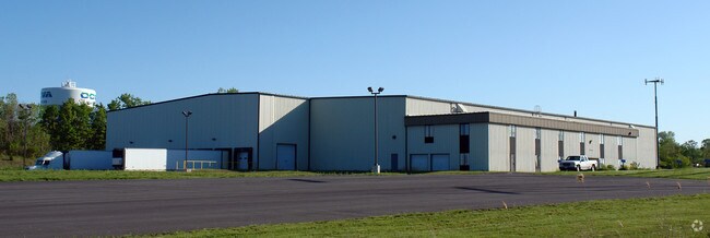
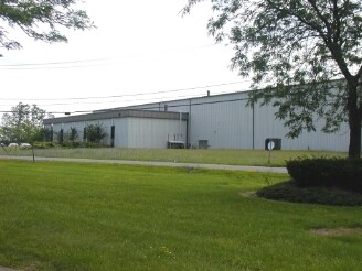
Property Record
7066 Interstate Island Rd, Syracuse, NY 13209


Save to a Folder
{{folder.Name}}
{{folder.ListingIds.length}} Properties
{{folder.ListingIds.length}} Property
Create a New Folder
Property Detail
7066 Interstate Island Rd
315689-056-000-0003-011-001-0000
Onondaga
Commercialbuilding
New York
INA
11.001
B and X Area of moderate flood hazard, usually the area between the limits of the 100-year and 500-year floods.
11.45 AC
2025
W Outer Onondaga County
2025
Syracuse
011900
Syracuse, NY
117,576 SF
NEARBY LISTINGS FOR SALE OR LEASE
DEMOGRAPHICS near 7066 Interstate Island Rd
1 mile
3 mile
5 mile
2025 Total Population
1,350
20,014
81,636
2030 Population
1,353
19,793
80,927
Pop Growth 2025-2030
+ 0.22%
(1.10%)
(0.87%)
Average Age
44
43
42
2025 Total Households
565
8,631
35,194
HH Growth 2025-2030
+ 0.18%
(1.18%)
(0.98%)
Median Household Inc
$67,115
$79,912
$80,292
Avg Household Size
2.30
2.30
2.30
2025 Avg HH Vehicles
2.00
2.00
2.00
Median Home Value
$147,719
$185,823
$191,143
Median Year Built
1958
1972
1971
Nearby Places
Map Layers
Map Styles
 Street
 Aerial
Layers
 Traffic
 Biking
Places
Listings with unknown addresses are not visible on the map
- Restaurants
- Banks
- Shops
- Fitness
- Groceries
PUBLIC TRANSPORTATION
COMMUTER RAIL
Syracuse Regional Transportation Center (Empire Service - Amtrak, Lake Shore Limited - Amtrak, Maple Leaf - Amtrak)
Drive
Walk
Distance
Syracuse Regional Transportation Center (Empire Service - Amtrak, Lake Shore Limited - Amtrak, Maple Leaf - Amtrak)
14 min
9.5 mi
AIRPORT
Syracuse Hancock International
Drive
Walk
Distance
Syracuse Hancock International
20 min
12.7 mi
Freight Ports
Albany, NY Port
Drive
Walk
Distance
Albany, NY Port
180 min
151.8 mi
Nearby Properties
Address
Land Use
TOTAL SIZE
Lot Size
Zoning
Address
Land Use
TOTAL SIZE
Lot Size
Zoning
7,392 SF
14.86 AC
03 - MULTI
Address
Land Use
TOTAL SIZE
Lot Size
Zoning
257,617 SF
50.74 AC
INA
Address
Land Use
TOTAL SIZE
Lot Size
Zoning
252,000 SF
58.54 AC
INA
Address
Land Use
TOTAL SIZE
Lot Size
Zoning
163,725 SF
21.46 AC
02 - SINGL
Address
Land Use
TOTAL SIZE
Lot Size
Zoning
57,993 SF
18.43 AC
02 - SINGL
Address
Land Use
TOTAL SIZE
Lot Size
Zoning
3,640 SF
27.54 AC
INC
Address
Land Use
TOTAL SIZE
Lot Size
Zoning
3,744 SF
10.60 AC
03 - MULTI
Address
Land Use
TOTAL SIZE
Lot Size
Zoning
3,696 SF
10.12 AC
03 - MULTI
Address
Land Use
TOTAL SIZE
Lot Size
Zoning
21,696 SF
11.96 AC
PUD
Address
Land Use
TOTAL SIZE
Lot Size
Zoning
515,918 SF
14.76 AC
05 - COMME
Address
Land Use
TOTAL SIZE
Lot Size
Zoning
182.16 AC
02 - SINGL
Address
Land Use
TOTAL SIZE
Lot Size
Zoning
77,978 SF
21.91 AC
INA
Address
Land Use
TOTAL SIZE
Lot Size
Zoning
38,620 SF
29.42 AC
02 - SINGL
Address
Land Use
TOTAL SIZE
Lot Size
Zoning
56,216 SF
18.97 AC
R15
Address
Land Use
TOTAL SIZE
Lot Size
Zoning
61,701 SF
15.87 AC
R40
Address
Land Use
TOTAL SIZE
Lot Size
Zoning
125,780 SF
10.13 AC
02 - SINGL
Address
Land Use
TOTAL SIZE
Lot Size
Zoning
8,624 SF
8.91 AC
PUD
Address
Land Use
TOTAL SIZE
Lot Size
Zoning
56,548 SF
17 AC
R10
Address
Land Use
TOTAL SIZE
Lot Size
Zoning
8,624 SF
7.77 AC
PUD
Address
Land Use
TOTAL SIZE
Lot Size
Zoning
68,076 SF
8.33 AC
03 - MULTI
Address
Land Use
TOTAL SIZE
Lot Size
Zoning
40,568 SF
24.23 AC
02 - SINGL
Address
Land Use
TOTAL SIZE
Lot Size
Zoning
8,624 SF
5.32 AC
PUD
Address
Land Use
TOTAL SIZE
Lot Size
Zoning
35,042 SF
4.39 AC
03 - MULTI
Address
Land Use
TOTAL SIZE
Lot Size
Zoning
11,640 SF
87.11 AC
02 - SINGL
Address
Land Use
TOTAL SIZE
Lot Size
Zoning
61,204 SF
8.19 AC
INA
Address
Land Use
TOTAL SIZE
Lot Size
Zoning
150,353 SF
12.26 AC
02 - SINGL
Address
Land Use
TOTAL SIZE
Lot Size
Zoning
16,216 SF
62.78 AC
RHD
Address
Land Use
TOTAL SIZE
Lot Size
Zoning
8,624 SF
4.48 AC
PUD
Address
Land Use
TOTAL SIZE
Lot Size
Zoning
33,962 SF
12.04 AC
03 - MULTI
Address
Land Use
TOTAL SIZE
Lot Size
Zoning
50,856 SF
3 AC
INA
The World's #1 Commercial Real Estate Marketplace
Connect with us
© 2026 CoStar Group
The information above has been obtained from sources believed reliable. While we do not doubt its accuracy we have not verified it and make no guarantee, warranty or representation about it. It is your responsibility to independently confirm its accuracy and completeness. Any projections, opinions, assumptions, or estimates used are for example only and do not represent the current or future performance of the property. The value of this transaction to you depends on tax and other factors which should be evaluated by your tax, financial, and legal advisors. You and your advisors should conduct a careful, independent investigation of the property to determine to your satisfaction the suitability of the property for your needs.