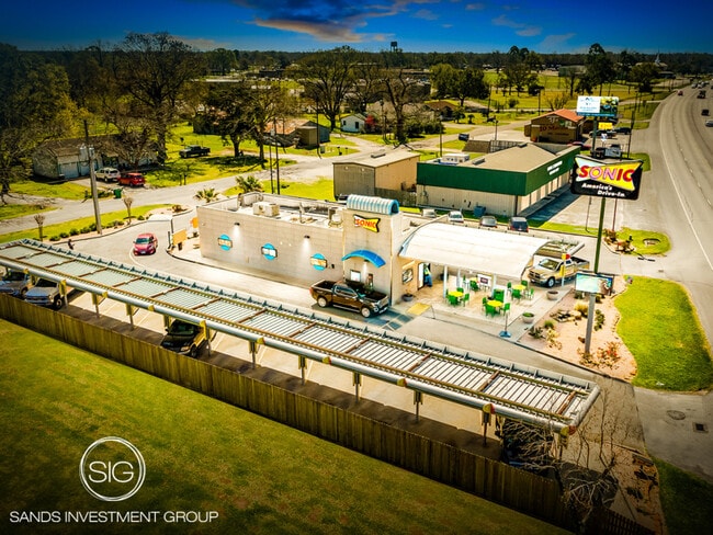
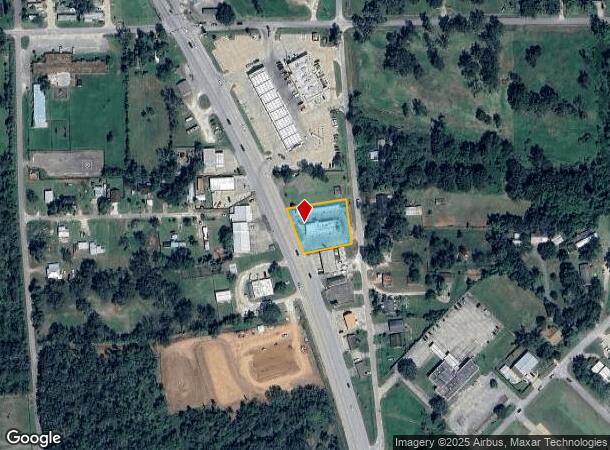
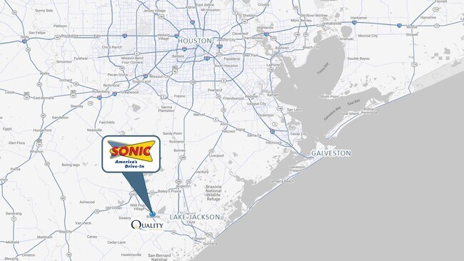
Property Record
707 N Highway 36, Brazoria, TX 77422
NEARBY LISTINGS FOR SALE OR LEASE
-
-
View all Brazoria listings for sale on LoopNet.com
Property Detail
707 N Highway 36
Houston-The Woodlands-Sugar Land, TX
Outlots & Townsite (Brazoria)
2040-0758-000
OUTLOTS & TOWNSITE (BRAZORIA) LOT 3A-3C3 OL 50 ACRES .557
Commercialnec
Brazoria
X
Texas
48039C0590K
3a
2024
0.56 AC
2025
Far New Territory
662900
Houston
1,522 SF
DEMOGRAPHICS near 707 N Highway 36
1 Mile
3 Mile
5 Mile
2024 Total Population
2,180
5,680
11,029
2029 Population
2,391
6,301
12,303
Pop Growth 2024-2029
+ 9.68%
+ 10.93%
+ 11.55%
Average Age
40
41
42
2024 Total Households
845
2,196
4,242
HH Growth 2024-2029
+ 9.82%
+ 11.16%
+ 11.74%
Median Household Inc
$63,836
$67,709
$72,993
Avg Household Size
2.60
2.60
2.60
2024 Avg HH Vehicles
2.00
2.00
2.00
Median Home Value
$176,292
$189,047
$241,428
Median Year Built
1978
1980
1985
Nearby Places
Map Layers
Map Styles
 Street
 Aerial
- Restaurants
- Banks
- Shops
- Fitness
- Groceries
SALE & LEASE HISTORY
LISTING DATE
SALE/LEASE

Jun 14, 2022
For Sale
Nearby Properties
Address
Land Use
TOTAL SIZE
Lot Size
Zoning
Address
Land Use
TOTAL SIZE
Lot Size
Zoning
4,830 SF
29.76 AC
Address
Land Use
TOTAL SIZE
Lot Size
Zoning
1,365.93 AC
Address
Land Use
TOTAL SIZE
Lot Size
Zoning
39,052 SF
4.66 AC
1000
Address
Land Use
TOTAL SIZE
Lot Size
Zoning
9,715 SF
3.55 AC
0028
Address
Land Use
TOTAL SIZE
Lot Size
Zoning
18,399 SF
1.01 AC
0015
Address
Land Use
TOTAL SIZE
Lot Size
Zoning
50.96 AC
0580
Address
Land Use
TOTAL SIZE
Lot Size
Zoning
2.25 AC
Address
Land Use
TOTAL SIZE
Lot Size
Zoning
70,745 SF
7.19 AC
Address
Land Use
TOTAL SIZE
Lot Size
Zoning
11,992 SF
3.97 AC
0014
Address
Land Use
TOTAL SIZE
Lot Size
Zoning
24,615 SF
6.32 AC
0012
Address
Land Use
TOTAL SIZE
Lot Size
Zoning
21,274 SF
5.43 AC
Address
Land Use
TOTAL SIZE
Lot Size
Zoning
51,490 SF
3.85 AC
0950
Address
Land Use
TOTAL SIZE
Lot Size
Zoning
5,383 SF
7.70 AC
Address
Land Use
TOTAL SIZE
Lot Size
Zoning
22,967 SF
28.14 AC
Address
Land Use
TOTAL SIZE
Lot Size
Zoning
36,524 SF
19.20 AC
0006
Address
Land Use
TOTAL SIZE
Lot Size
Zoning
45,108 SF
3.21 AC
Address
Land Use
TOTAL SIZE
Lot Size
Zoning
1,951 SF
14.32 AC
7570
Address
Land Use
TOTAL SIZE
Lot Size
Zoning
40,024 SF
1.93 AC
0019
Address
Land Use
TOTAL SIZE
Lot Size
Zoning
9,140 SF
2.27 AC
0695
Address
Land Use
TOTAL SIZE
Lot Size
Zoning
7,017 SF
0.24 AC
0092
Address
Land Use
TOTAL SIZE
Lot Size
Zoning
18,387 SF
1.07 AC
0002
Address
Land Use
TOTAL SIZE
Lot Size
Zoning
25,580 SF
2.03 AC
Address
Land Use
TOTAL SIZE
Lot Size
Zoning
1,110 SF
98.41 AC
Address
Land Use
TOTAL SIZE
Lot Size
Zoning
28,250 SF
3.97 AC
7500
Address
Land Use
TOTAL SIZE
Lot Size
Zoning
9,700 SF
1.13 AC
Address
Land Use
TOTAL SIZE
Lot Size
Zoning
2 SF
6.75 AC
0092
Address
Land Use
TOTAL SIZE
Lot Size
Zoning
7,268 SF
1.83 AC
0900
Address
Land Use
TOTAL SIZE
Lot Size
Zoning
14,400 SF
1.74 AC
0520
Address
Land Use
TOTAL SIZE
Lot Size
Zoning
7,804 SF
1.06 AC
0012
Address
Land Use
TOTAL SIZE
Lot Size
Zoning
11,750 SF
6.91 AC
0940
The World's #1 Commercial Real Estate Marketplace
Connect with us
© 2025 CoStar Group
The information above has been obtained from sources believed reliable. While we do not doubt its accuracy we have not verified it and make no guarantee, warranty or representation about it. It is your responsibility to independently confirm its accuracy and completeness. Any projections, opinions, assumptions, or estimates used are for example only and do not represent the current or future performance of the property. The value of this transaction to you depends on tax and other factors which should be evaluated by your tax, financial, and legal advisors. You and your advisors should conduct a careful, independent investigation of the property to determine to your satisfaction the suitability of the property for your needs.