Property Record
707 N Waldrip St, Grand Saline, TX 75140
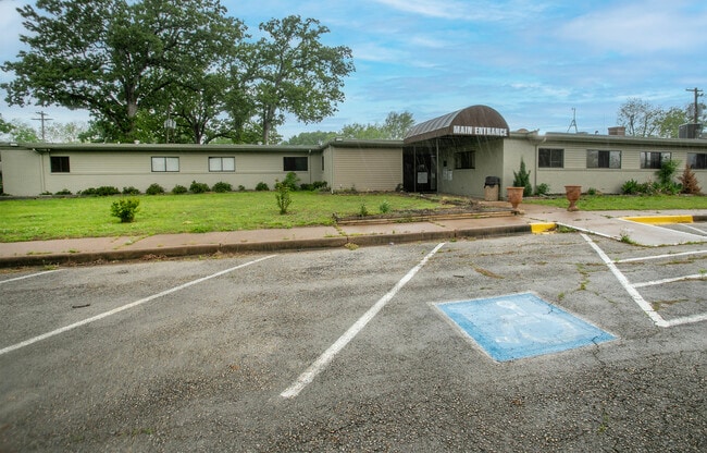

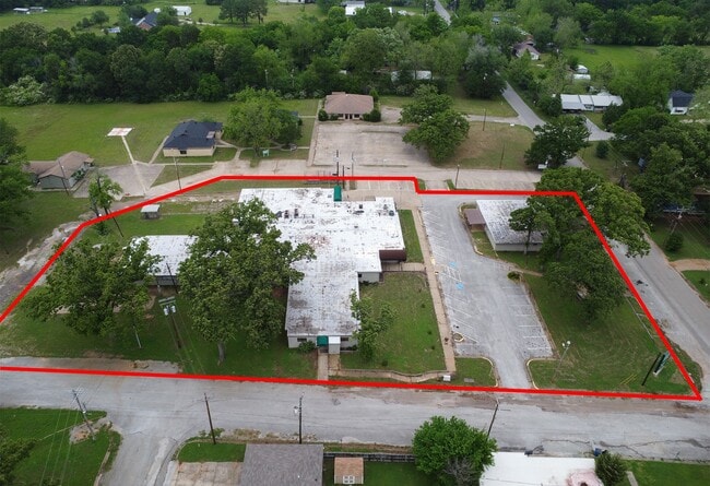

This Property Is For Sale
Current Lease Availabilities
Property Detail
707 N Waldrip St
R000013466
ACRES: 5.660 ABST: 46 SUR: SAM BELL; ADDN: COLLIER BLK 1 LT 1-14;ADDN: SHANGRILA HTS BLK 12 LT 1-3
Commercialnec
Van Zandt
B and X Area of moderate flood hazard, usually the area between the limits of the 100-year and 500-year floods.
Texas
2024
1-14
2025
5.66 AC
950200
Texas East Area
13,160 SF
Other Market Areas
NEARBY LISTINGS FOR SALE OR LEASE
DEMOGRAPHICS near 707 N Waldrip St
1 mile
3 mile
5 mile
2025 Total Population
2,696
5,144
7,750
2030 Population
2,929
5,587
8,409
Pop Growth 2025-2030
+ 8.64%
+ 8.61%
+ 8.50%
Average Age
39
40
41
2025 Total Households
993
1,871
2,871
HH Growth 2025-2030
+ 8.46%
+ 8.50%
+ 8.36%
Median Household Inc
$45,139
$51,046
$53,882
Avg Household Size
2.70
2.60
2.60
2025 Avg HH Vehicles
2.00
2.00
2.00
Median Home Value
$127,513
$144,126
$160,826
Median Year Built
1973
1974
1976
Nearby Places
Map Layers
Map Styles
 Street
 Aerial
Layers
 Traffic
 Biking
Places
Listings with unknown addresses are not visible on the map
- Restaurants
- Banks
- Shops
- Fitness
- Groceries
PUBLIC TRANSPORTATION
AIRPORT
Tyler Pounds Regional
Drive
Walk
Distance
Tyler Pounds Regional
52 min
40.2 mi
Freight Ports
Port of Shreveport
Drive
Walk
Distance
Port of Shreveport
157 min
138.8 mi
Nearby Properties
Address
Land Use
TOTAL SIZE
Lot Size
Zoning
Address
Land Use
TOTAL SIZE
Lot Size
Zoning
22,264 SF
7.19 AC
Address
Land Use
TOTAL SIZE
Lot Size
Zoning
32,352 SF
8 AC
Address
Land Use
TOTAL SIZE
Lot Size
Zoning
30,037 SF
1.50 AC
Address
Land Use
TOTAL SIZE
Lot Size
Zoning
9,300 SF
3.15 AC
Address
Land Use
TOTAL SIZE
Lot Size
Zoning
18,559 SF
140.50 AC
Address
Land Use
TOTAL SIZE
Lot Size
Zoning
8,960 SF
2.89 AC
Address
Land Use
TOTAL SIZE
Lot Size
Zoning
4,920 SF
0.77 AC
Address
Land Use
TOTAL SIZE
Lot Size
Zoning
12,200 SF
3 AC
Address
Land Use
TOTAL SIZE
Lot Size
Zoning
31,556 SF
10 AC
Address
Land Use
TOTAL SIZE
Lot Size
Zoning
24,900 SF
4.47 AC
Address
Land Use
TOTAL SIZE
Lot Size
Zoning
1,636 SF
28.38 AC
Address
Land Use
TOTAL SIZE
Lot Size
Zoning
7,560 SF
4.64 AC
Address
Land Use
TOTAL SIZE
Lot Size
Zoning
6,146 SF
5 AC
Address
Land Use
TOTAL SIZE
Lot Size
Zoning
20,698 SF
1.67 AC
Address
Land Use
TOTAL SIZE
Lot Size
Zoning
6,140 SF
0.79 AC
Address
Land Use
TOTAL SIZE
Lot Size
Zoning
5,432 SF
11.26 AC
Address
Land Use
TOTAL SIZE
Lot Size
Zoning
19,960 SF
2.20 AC
Address
Land Use
TOTAL SIZE
Lot Size
Zoning
2,884 SF
23.77 AC
Address
Land Use
TOTAL SIZE
Lot Size
Zoning
Address
Land Use
TOTAL SIZE
Lot Size
Zoning
6,366 SF
2.57 AC
Address
Land Use
TOTAL SIZE
Lot Size
Zoning
864 SF
128.85 AC
Address
Land Use
TOTAL SIZE
Lot Size
Zoning
4,976 SF
109.81 AC
Address
Land Use
TOTAL SIZE
Lot Size
Zoning
15,034 SF
3.05 AC
Address
Land Use
TOTAL SIZE
Lot Size
Zoning
2,820 SF
26.50 AC
Address
Land Use
TOTAL SIZE
Lot Size
Zoning
4,480 SF
1.54 AC
Address
Land Use
TOTAL SIZE
Lot Size
Zoning
15,000 SF
1.80 AC
The World's #1 Commercial Real Estate Marketplace
Connect with us
© 2026 CoStar Group
The information above has been obtained from sources believed reliable. While we do not doubt its accuracy we have not verified it and make no guarantee, warranty or representation about it. It is your responsibility to independently confirm its accuracy and completeness. Any projections, opinions, assumptions, or estimates used are for example only and do not represent the current or future performance of the property. The value of this transaction to you depends on tax and other factors which should be evaluated by your tax, financial, and legal advisors. You and your advisors should conduct a careful, independent investigation of the property to determine to your satisfaction the suitability of the property for your needs.