Property Record
707 Parsons Rd, Traverse City, MI 49686
NEARBY LISTINGS FOR SALE OR LEASE
Property Detail
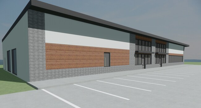
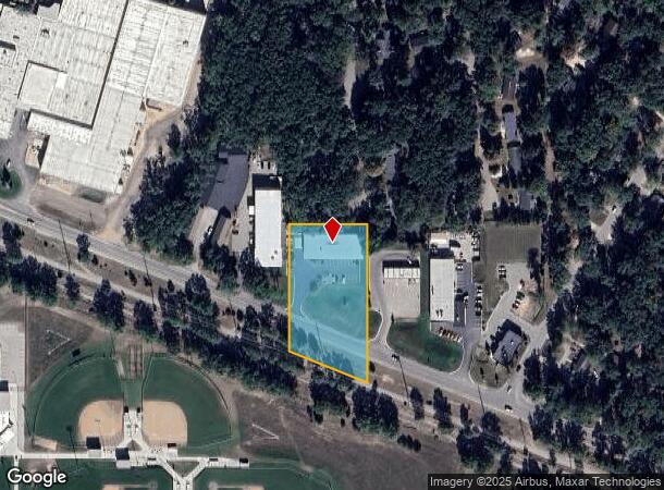
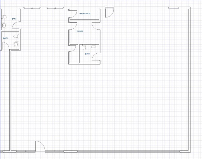
707 Parsons Rd
51-112-014-50
Westminster Woods
Departmentstore
PART OF THE NE 1/4 OF THE SE 1/4 OF SEC 12, T27N, R11W, CITY OF TC, MORE FULLY DESCRIBED AS: COMM AT
X
Grand Traverse
26055C0114D
Michigan
2024
1.68 AC
2025
Michigan Northwest Area
551100
Other Market Areas
9,000 SF
Traverse City, MI
DEMOGRAPHICS near 707 Parsons Rd
1 Mile
3 Mile
5 Mile
2024 Total Population
2,860
24,953
45,131
2029 Population
2,953
25,768
46,613
Pop Growth 2024-2029
+ 3.25%
+ 3.27%
+ 3.28%
Average Age
43
44
44
2024 Total Households
1,302
11,726
20,444
HH Growth 2024-2029
+ 3.23%
+ 3.24%
+ 3.28%
Median Household Inc
$62,098
$56,575
$62,903
Avg Household Size
2.00
2.00
2.10
2024 Avg HH Vehicles
2.00
2.00
2.00
Median Home Value
$274,542
$273,174
$292,383
Median Year Built
1966
1977
1982
Nearby Places
Map Layers
Map Styles
 Street
 Aerial
- Restaurants
- Banks
- Shops
- Fitness
- Groceries
PUBLIC TRANSPORTATION
AIRPORT
Cherry Capital
DRIVE
WALK
Distance
Cherry Capital
5 min
1.1 mi
Freight Ports
Port Milwaukee
DRIVE
WALK
Distance
Port Milwaukee
462 min
402.6 mi
SALE & LEASE HISTORY
LISTING DATE
SALE/LEASE

Oct 21, 2024
For Lease
Aug 28, 2023
For Lease
Nearby Properties
Address
Land Use
TOTAL SIZE
Lot Size
Zoning
Address
Land Use
TOTAL SIZE
Lot Size
Zoning
81,900 SF
870.88 AC
Address
Land Use
TOTAL SIZE
Lot Size
Zoning
103,000 SF
4.77 AC
Address
Land Use
TOTAL SIZE
Lot Size
Zoning
5,308 SF
27.64 AC
Address
Land Use
TOTAL SIZE
Lot Size
Zoning
123,544 SF
3.93 AC
Address
Land Use
TOTAL SIZE
Lot Size
Zoning
53,806 SF
77.29 AC
Address
Land Use
TOTAL SIZE
Lot Size
Zoning
41,084 SF
22.79 AC
Address
Land Use
TOTAL SIZE
Lot Size
Zoning
75,085 SF
0.84 AC
Address
Land Use
TOTAL SIZE
Lot Size
Zoning
25,208 SF
15.01 AC
Address
Land Use
TOTAL SIZE
Lot Size
Zoning
72,997 SF
0.65 AC
Address
Land Use
TOTAL SIZE
Lot Size
Zoning
78,393 SF
7.83 AC
Address
Land Use
TOTAL SIZE
Lot Size
Zoning
77,000 SF
1.71 AC
Address
Land Use
TOTAL SIZE
Lot Size
Zoning
6,354 SF
97.88 AC
Address
Land Use
TOTAL SIZE
Lot Size
Zoning
Address
Land Use
TOTAL SIZE
Lot Size
Zoning
40,790 SF
2.31 AC
Address
Land Use
TOTAL SIZE
Lot Size
Zoning
33,184 SF
0.76 AC
Address
Land Use
TOTAL SIZE
Lot Size
Zoning
139,710 SF
8.04 AC
Address
Land Use
TOTAL SIZE
Lot Size
Zoning
155,000 SF
12.63 AC
Address
Land Use
TOTAL SIZE
Lot Size
Zoning
89,143 SF
2.73 AC
Address
Land Use
TOTAL SIZE
Lot Size
Zoning
8,820 SF
15.24 AC
Address
Land Use
TOTAL SIZE
Lot Size
Zoning
38,232 SF
0.65 AC
Address
Land Use
TOTAL SIZE
Lot Size
Zoning
28,620 SF
3.86 AC
Address
Land Use
TOTAL SIZE
Lot Size
Zoning
54,254 SF
4.83 AC
Address
Land Use
TOTAL SIZE
Lot Size
Zoning
720 SF
3.80 AC
Address
Land Use
TOTAL SIZE
Lot Size
Zoning
45,574 SF
21.75 AC
Address
Land Use
TOTAL SIZE
Lot Size
Zoning
11.25 AC
Address
Land Use
TOTAL SIZE
Lot Size
Zoning
186,482 SF
1.43 AC
Address
Land Use
TOTAL SIZE
Lot Size
Zoning
65,392 SF
1.54 AC
Address
Land Use
TOTAL SIZE
Lot Size
Zoning
78,933 SF
19.79 AC
Address
Land Use
TOTAL SIZE
Lot Size
Zoning
17,892 SF
18.28 AC
Address
Land Use
TOTAL SIZE
Lot Size
Zoning
65,775 SF
1.99 AC
The World's #1 Commercial Real Estate Marketplace
Connect with us
© 2025 CoStar Group
The information above has been obtained from sources believed reliable. While we do not doubt its accuracy we have not verified it and make no guarantee, warranty or representation about it. It is your responsibility to independently confirm its accuracy and completeness. Any projections, opinions, assumptions, or estimates used are for example only and do not represent the current or future performance of the property. The value of this transaction to you depends on tax and other factors which should be evaluated by your tax, financial, and legal advisors. You and your advisors should conduct a careful, independent investigation of the property to determine to your satisfaction the suitability of the property for your needs.