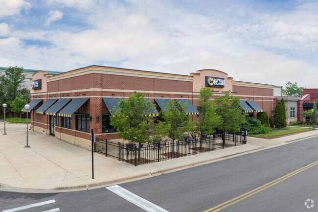
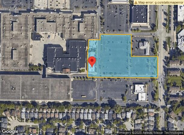
Property Record
7020 S Carpenter Rd, Skokie, IL 60077

NEARBY LISTINGS FOR SALE OR LEASE
Property Detail
7020 S Carpenter Rd
10-33-122-004-0000
Cook
Commercialbuilding
Illinois
X
5.09 AC
17031C0244J
Near North
2023
Chicago
2025
Chicago-Naperville-Elgin, IL-IN-WI
807800
DEMOGRAPHICS near 7020 S Carpenter Rd
1 Mile
3 Mile
5 Mile
2024 Total Population
13,327
186,542
695,936
2029 Population
12,858
180,302
669,523
Pop Growth 2024-2029
(3.52%)
(3.35%)
(3.80%)
Average Age
43
43
41
2024 Total Households
4,568
69,472
262,925
HH Growth 2024-2029
(3.85%)
(3.71%)
(4.12%)
Median Household Inc
$129,928
$86,760
$81,143
Avg Household Size
2.80
2.60
2.50
2024 Avg HH Vehicles
2.00
2.00
2.00
Median Home Value
$475,908
$366,287
$370,657
Median Year Built
1955
1955
1953
Nearby Places
Map Layers
Map Styles
 Street
 Aerial
- Restaurants
- Banks
- Shops
- Fitness
- Groceries
PUBLIC TRANSPORTATION
COMMUTER RAIL
Edgebrook Station (Milwaukee District North Line - Northeast Illinois Regional Commuter Railroad (Metra))
DRIVE
WALK
Distance
Edgebrook Station (Milwaukee District North Line - Northeast Illinois Regional Commuter Railroad (Metra))
3 min
1.1 mi
Morton Grove Station (Milwaukee District North Line - Northeast Illinois Regional Commuter Railroad (Metra))
DRIVE
WALK
Distance
Morton Grove Station (Milwaukee District North Line - Northeast Illinois Regional Commuter Railroad (Metra))
6 min
2.4 mi
AIRPORT
Chicago O'Hare International
DRIVE
WALK
Distance
Chicago O'Hare International
18 min
9.3 mi
Chicago Midway International
DRIVE
WALK
Distance
Chicago Midway International
31 min
16.6 mi
Nearby Properties
Address
Land Use
TOTAL SIZE
Lot Size
Zoning
Address
Land Use
TOTAL SIZE
Lot Size
Zoning
999,808 SF
50.13 AC
Address
Land Use
TOTAL SIZE
Lot Size
Zoning
240,942 SF
15.94 AC
PD 72
Address
Land Use
TOTAL SIZE
Lot Size
Zoning
203,090 SF
7.96 AC
Address
Land Use
TOTAL SIZE
Lot Size
Zoning
Address
Land Use
TOTAL SIZE
Lot Size
Zoning
24.49 AC
Address
Land Use
TOTAL SIZE
Lot Size
Zoning
892,012 SF
37.29 AC
Address
Land Use
TOTAL SIZE
Lot Size
Zoning
Address
Land Use
TOTAL SIZE
Lot Size
Zoning
305,592 SF
27.35 AC
Address
Land Use
TOTAL SIZE
Lot Size
Zoning
414,878 SF
20.79 AC
Address
Land Use
TOTAL SIZE
Lot Size
Zoning
172,500 SF
2.42 AC
Address
Land Use
TOTAL SIZE
Lot Size
Zoning
10.24 AC
Address
Land Use
TOTAL SIZE
Lot Size
Zoning
16.27 AC
Address
Land Use
TOTAL SIZE
Lot Size
Zoning
82,139 SF
4.88 AC
Address
Land Use
TOTAL SIZE
Lot Size
Zoning
21.56 AC
RS-2
Address
Land Use
TOTAL SIZE
Lot Size
Zoning
PD 184
Address
Land Use
TOTAL SIZE
Lot Size
Zoning
429,949 SF
16.06 AC
Address
Land Use
TOTAL SIZE
Lot Size
Zoning
9.38 AC
PD 1179,PO
Address
Land Use
TOTAL SIZE
Lot Size
Zoning
315,373 SF
26.19 AC
Address
Land Use
TOTAL SIZE
Lot Size
Zoning
92,457 SF
4.09 AC
Address
Land Use
TOTAL SIZE
Lot Size
Zoning
139.71 AC
PD 184
Address
Land Use
TOTAL SIZE
Lot Size
Zoning
231,865 SF
3.16 AC
Address
Land Use
TOTAL SIZE
Lot Size
Zoning
43,765 SF
2.79 AC
Address
Land Use
TOTAL SIZE
Lot Size
Zoning
63,700 SF
7.42 AC
PD 796
Address
Land Use
TOTAL SIZE
Lot Size
Zoning
486,884 SF
16.41 AC
Address
Land Use
TOTAL SIZE
Lot Size
Zoning
424,257 SF
Address
Land Use
TOTAL SIZE
Lot Size
Zoning
269,500 SF
11.03 AC
Address
Land Use
TOTAL SIZE
Lot Size
Zoning
100,900 SF
4.85 AC
PD 1415
Address
Land Use
TOTAL SIZE
Lot Size
Zoning
98,185 SF
4.66 AC
Address
Land Use
TOTAL SIZE
Lot Size
Zoning
5.60 AC
Address
Land Use
TOTAL SIZE
Lot Size
Zoning
19.42 AC
The World's #1 Commercial Real Estate Marketplace
Connect with us
© 2025 CoStar Group
The information above has been obtained from sources believed reliable. While we do not doubt its accuracy we have not verified it and make no guarantee, warranty or representation about it. It is your responsibility to independently confirm its accuracy and completeness. Any projections, opinions, assumptions, or estimates used are for example only and do not represent the current or future performance of the property. The value of this transaction to you depends on tax and other factors which should be evaluated by your tax, financial, and legal advisors. You and your advisors should conduct a careful, independent investigation of the property to determine to your satisfaction the suitability of the property for your needs.