Property Record
7100 Scales Rd, Lithonia, GA 30058
This Property Is For Sale
NEARBY LISTINGS FOR SALE OR LEASE
Property Detail
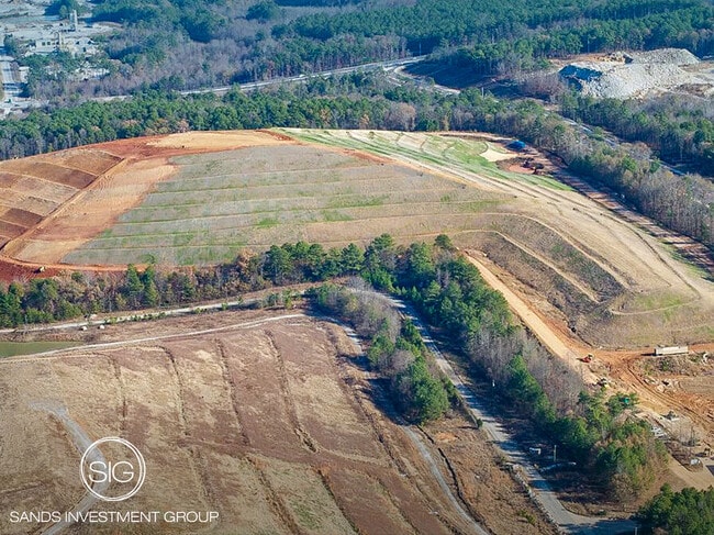
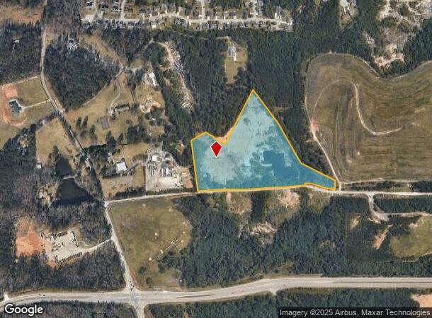
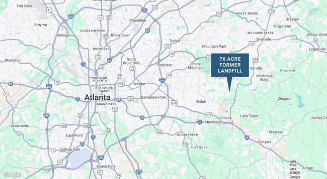
7100 Scales Rd
Atlanta-Sandy Springs-Roswell, GA
38 X 78 X 83 X 140 X 20 X 976 X 446 X 171 X 208 X 565 X 38 434 14.15AC 4-5-95
16-157-01-004
DeKalb
Industrialacreage
Georgia
X
4
13247C0080D
14.30 AC
2025
I-20 East/Conyers
2025
Atlanta
023315
DEMOGRAPHICS near 7100 Scales Rd
1 Mile
3 Mile
5 Mile
2024 Total Population
3,604
47,206
140,189
2029 Population
3,582
47,065
140,821
Pop Growth 2024-2029
(0.61%)
(0.30%)
+ 0.45%
Average Age
37
39
38
2024 Total Households
1,142
16,154
49,621
HH Growth 2024-2029
(0.70%)
(0.30%)
+ 0.29%
Median Household Inc
$91,891
$70,167
$66,100
Avg Household Size
3.00
2.90
2.70
2024 Avg HH Vehicles
2.00
2.00
2.00
Median Home Value
$216,307
$214,750
$214,069
Median Year Built
2003
1993
1991
Nearby Places
- Restaurants
- Banks
- Shops
- Fitness
- Groceries
PUBLIC TRANSPORTATION
AIRPORT
Hartsfield - Jackson Atlanta International
DRIVE
WALK
Distance
Hartsfield - Jackson Atlanta International
37 min
24.2 mi
Freight Ports
Georgia Ports - Savannah
DRIVE
WALK
Distance
Georgia Ports - Savannah
286 min
244.1 mi
Nearby Properties
Address
Land Use
TOTAL SIZE
Lot Size
Zoning
Address
Land Use
TOTAL SIZE
Lot Size
Zoning
614,505 SF
97.30 AC
Address
Land Use
TOTAL SIZE
Lot Size
Zoning
764,622 SF
48.38 AC
M
Address
Land Use
TOTAL SIZE
Lot Size
Zoning
240,744 SF
23.93 AC
RM100
Address
Land Use
TOTAL SIZE
Lot Size
Zoning
271,666 SF
33.72 AC
RM100
Address
Land Use
TOTAL SIZE
Lot Size
Zoning
7,384 SF
15.80 AC
M
Address
Land Use
TOTAL SIZE
Lot Size
Zoning
215,422 SF
33.84 AC
M
Address
Land Use
TOTAL SIZE
Lot Size
Zoning
227,648 SF
14.56 AC
X
Address
Land Use
TOTAL SIZE
Lot Size
Zoning
18,099 SF
1,412.45 AC
M2
Address
Land Use
TOTAL SIZE
Lot Size
Zoning
207,446 SF
12.21 AC
M
Address
Land Use
TOTAL SIZE
Lot Size
Zoning
253,861 SF
19.28 AC
X
Address
Land Use
TOTAL SIZE
Lot Size
Zoning
38.94 AC
M
Address
Land Use
TOTAL SIZE
Lot Size
Zoning
142,160 SF
9.50 AC
M
Address
Land Use
TOTAL SIZE
Lot Size
Zoning
96,679 SF
8.38 AC
RM75
Address
Land Use
TOTAL SIZE
Lot Size
Zoning
150,000 SF
13.24 AC
M
Address
Land Use
TOTAL SIZE
Lot Size
Zoning
94,220 SF
4.60 AC
RM75
Address
Land Use
TOTAL SIZE
Lot Size
Zoning
21.53 AC
M
Address
Land Use
TOTAL SIZE
Lot Size
Zoning
94,296 SF
8.94 AC
Address
Land Use
TOTAL SIZE
Lot Size
Zoning
112,474 SF
9.20 AC
M
Address
Land Use
TOTAL SIZE
Lot Size
Zoning
94,581 SF
5.58 AC
M
Address
Land Use
TOTAL SIZE
Lot Size
Zoning
47,628 SF
10.69 AC
X
Address
Land Use
TOTAL SIZE
Lot Size
Zoning
98,676 SF
17.75 AC
C1
Address
Land Use
TOTAL SIZE
Lot Size
Zoning
99,876 SF
11.81 AC
M2
Address
Land Use
TOTAL SIZE
Lot Size
Zoning
96,725 SF
0.02 AC
C1
Address
Land Use
TOTAL SIZE
Lot Size
Zoning
181,160 SF
14.94 AC
M
Address
Land Use
TOTAL SIZE
Lot Size
Zoning
104,000 SF
5.11 AC
M
Address
Land Use
TOTAL SIZE
Lot Size
Zoning
67,445 SF
12 AC
X
Address
Land Use
TOTAL SIZE
Lot Size
Zoning
188.98 AC
M2
Address
Land Use
TOTAL SIZE
Lot Size
Zoning
72,160 SF
4.13 AC
X
Address
Land Use
TOTAL SIZE
Lot Size
Zoning
1,336 SF
8.27 AC
M
Address
Land Use
TOTAL SIZE
Lot Size
Zoning
72,799 SF
37.42 AC
X
The World's #1 Commercial Real Estate Marketplace
Connect with us
© 2025 CoStar Group
The information above has been obtained from sources believed reliable. While we do not doubt its accuracy we have not verified it and make no guarantee, warranty or representation about it. It is your responsibility to independently confirm its accuracy and completeness. Any projections, opinions, assumptions, or estimates used are for example only and do not represent the current or future performance of the property. The value of this transaction to you depends on tax and other factors which should be evaluated by your tax, financial, and legal advisors. You and your advisors should conduct a careful, independent investigation of the property to determine to your satisfaction the suitability of the property for your needs.