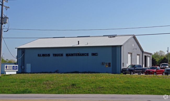
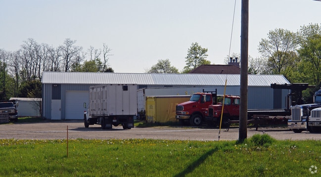
Property Record
7070 State Route 47, Yorkville, IL 60560

NEARBY LISTINGS FOR SALE OR LEASE
Property Detail
7070 State Route 47
Chicago-Naperville-Elgin, IL-IN-WI
City Of Yorkville
05-08-226-003
SEC 4, 5, 8 & 9-36-7 COM INT C/L RT 47 & 71, SE ALG C/L RT 47 320.5 TO POB E 400 S 517.28 W 368.69 TO C/L RT 47 NW 429 TO POB CITY OF YORKVILLE
Commercialnec
Kendall
X
Illinois
17093C0125G
3.48 AC
2024
Joliet Area
2024
Chicago
890602
DEMOGRAPHICS near 7070 State Route 47
1 Mile
3 Mile
5 Mile
2024 Total Population
4,035
16,023
34,746
2029 Population
4,539
17,804
38,595
Pop Growth 2024-2029
+ 12.49%
+ 11.12%
+ 11.08%
Average Age
38
39
38
2024 Total Households
1,413
5,713
11,758
HH Growth 2024-2029
+ 12.38%
+ 11.04%
+ 11.09%
Median Household Inc
$93,652
$95,989
$98,575
Avg Household Size
2.90
2.80
2.90
2024 Avg HH Vehicles
2.00
2.00
2.00
Median Home Value
$301,444
$305,136
$280,993
Median Year Built
2003
1999
2002
Nearby Places
Map Layers
Map Styles
 Street
 Aerial
- Restaurants
- Banks
- Shops
- Fitness
- Groceries
PUBLIC TRANSPORTATION
COMMUTER RAIL
DRIVE
WALK
Distance
16 min
7.9 mi
Nearby Properties
Address
Land Use
TOTAL SIZE
Lot Size
Zoning
Address
Land Use
TOTAL SIZE
Lot Size
Zoning
339,430 SF
6.18 AC
Address
Land Use
TOTAL SIZE
Lot Size
Zoning
64,781 SF
1.62 AC
Address
Land Use
TOTAL SIZE
Lot Size
Zoning
58,960 SF
1.27 AC
Address
Land Use
TOTAL SIZE
Lot Size
Zoning
54,910 SF
0.88 AC
Address
Land Use
TOTAL SIZE
Lot Size
Zoning
38,500 SF
7.06 AC
Address
Land Use
TOTAL SIZE
Lot Size
Zoning
29,693 SF
5.67 AC
Address
Land Use
TOTAL SIZE
Lot Size
Zoning
4,968 SF
1.35 AC
Address
Land Use
TOTAL SIZE
Lot Size
Zoning
19,012 SF
3.02 AC
Address
Land Use
TOTAL SIZE
Lot Size
Zoning
59,106 SF
3.46 AC
Address
Land Use
TOTAL SIZE
Lot Size
Zoning
60,078 SF
3.18 AC
Address
Land Use
TOTAL SIZE
Lot Size
Zoning
52,278 SF
1.75 AC
Address
Land Use
TOTAL SIZE
Lot Size
Zoning
20,850 SF
1.06 AC
Address
Land Use
TOTAL SIZE
Lot Size
Zoning
3,538 SF
2.47 AC
Address
Land Use
TOTAL SIZE
Lot Size
Zoning
2.01 AC
Address
Land Use
TOTAL SIZE
Lot Size
Zoning
21,620 SF
1.45 AC
Address
Land Use
TOTAL SIZE
Lot Size
Zoning
43,276 SF
3.60 AC
Address
Land Use
TOTAL SIZE
Lot Size
Zoning
3,772 SF
1.51 AC
Address
Land Use
TOTAL SIZE
Lot Size
Zoning
28,416 SF
0.98 AC
Address
Land Use
TOTAL SIZE
Lot Size
Zoning
20,019 SF
1.46 AC
Address
Land Use
TOTAL SIZE
Lot Size
Zoning
14,748 SF
1.87 AC
Address
Land Use
TOTAL SIZE
Lot Size
Zoning
17,997 SF
3.52 AC
Address
Land Use
TOTAL SIZE
Lot Size
Zoning
10,735 SF
1.31 AC
Address
Land Use
TOTAL SIZE
Lot Size
Zoning
21,600 SF
1.36 AC
Address
Land Use
TOTAL SIZE
Lot Size
Zoning
45,467 SF
1.64 AC
Address
Land Use
TOTAL SIZE
Lot Size
Zoning
14,480 SF
4.28 AC
Address
Land Use
TOTAL SIZE
Lot Size
Zoning
19,076 SF
0.77 AC
Address
Land Use
TOTAL SIZE
Lot Size
Zoning
27,080 SF
3 AC
Address
Land Use
TOTAL SIZE
Lot Size
Zoning
12,377 SF
1.26 AC
Address
Land Use
TOTAL SIZE
Lot Size
Zoning
51,011 SF
1.94 AC
The World's #1 Commercial Real Estate Marketplace
Connect with us
© 2026 CoStar Group
The information above has been obtained from sources believed reliable. While we do not doubt its accuracy we have not verified it and make no guarantee, warranty or representation about it. It is your responsibility to independently confirm its accuracy and completeness. Any projections, opinions, assumptions, or estimates used are for example only and do not represent the current or future performance of the property. The value of this transaction to you depends on tax and other factors which should be evaluated by your tax, financial, and legal advisors. You and your advisors should conduct a careful, independent investigation of the property to determine to your satisfaction the suitability of the property for your needs.