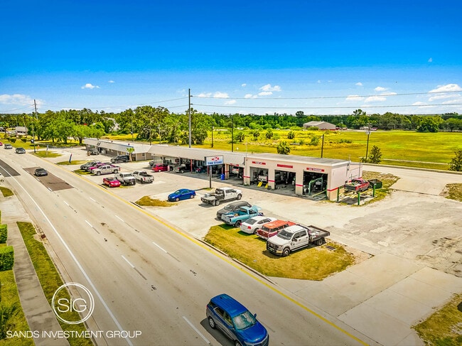
Property Record
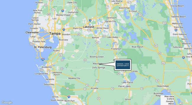
708 N 6Th Ave, Wauchula, FL 33873

NEARBY LISTINGS FOR SALE OR LEASE
-
-
View all Wauchula listings for sale on LoopNet.com
Property Detail
708 N 6Th Ave
0434-25-0240-00002-0001
Bloodworth Subd
Storemultistory
BEG AT SW COR OF NE1/4 OF NE1/4 E 335.38 FT TO PT ON W/LY R/W OF ACL RR TO POB N 12 DEG 14M 08S W ALONG R/W 200 FT W 52.75 FT S ALONG HWY 17 R/W 196.20 FT TO S LINE OF NE1/4 OF NE1/4 E 92.31 FT TO POB 04 34S 25E 188P374 249P33 250P102 264P188P198P199
X
Hardee
12049C0187D
Florida
2025
0.22 AC
2025
Florida Central South Area
970301
Other Market Areas
2,910 SF
Wauchula, FL
DEMOGRAPHICS near 708 N 6Th Ave
1 Mile
3 Mile
5 Mile
2024 Total Population
3,632
10,917
15,789
2029 Population
3,697
11,184
16,143
Pop Growth 2024-2029
+ 1.79%
+ 2.45%
+ 2.24%
Average Age
34
36
37
2024 Total Households
1,175
3,647
5,343
HH Growth 2024-2029
+ 1.87%
+ 2.60%
+ 2.40%
Median Household Inc
$32,421
$34,212
$42,416
Avg Household Size
3.00
2.90
2.90
2024 Avg HH Vehicles
2.00
2.00
2.00
Median Home Value
$116,193
$144,968
$131,209
Median Year Built
1976
1978
1979
Nearby Places
Map Layers
Map Styles
 Street
 Aerial
- Restaurants
- Banks
- Shops
- Fitness
- Groceries
SALE & LEASE HISTORY
LISTING DATE
SALE/LEASE

Jul 14, 2023
For Sale
Nearby Properties
Address
Land Use
TOTAL SIZE
Lot Size
Zoning
Address
Land Use
TOTAL SIZE
Lot Size
Zoning
60.50 AC
F-R
Address
Land Use
TOTAL SIZE
Lot Size
Zoning
25 AC
F-R
Address
Land Use
TOTAL SIZE
Lot Size
Zoning
22.21 AC
P-SP
Address
Land Use
TOTAL SIZE
Lot Size
Zoning
47,399 SF
55.51 AC
C-2
Address
Land Use
TOTAL SIZE
Lot Size
Zoning
50,071 SF
9.78 AC
C-2
Address
Land Use
TOTAL SIZE
Lot Size
Zoning
59,117 SF
70 AC
A-1
Address
Land Use
TOTAL SIZE
Lot Size
Zoning
107,610 SF
14.32 AC
C-1
Address
Land Use
TOTAL SIZE
Lot Size
Zoning
122,608 SF
10.32 AC
R-3
Address
Land Use
TOTAL SIZE
Lot Size
Zoning
45,018 SF
17.48 AC
P-SP
Address
Land Use
TOTAL SIZE
Lot Size
Zoning
40,161 SF
4.48 AC
C-1
Address
Land Use
TOTAL SIZE
Lot Size
Zoning
1,260 SF
39.68 AC
P-I
Address
Land Use
TOTAL SIZE
Lot Size
Zoning
104,690 SF
9.96 AC
F-R
Address
Land Use
TOTAL SIZE
Lot Size
Zoning
89,500 SF
6.80 AC
C-2
Address
Land Use
TOTAL SIZE
Lot Size
Zoning
54,007 SF
9 AC
P-SP
Address
Land Use
TOTAL SIZE
Lot Size
Zoning
13.28 AC
F-R
Address
Land Use
TOTAL SIZE
Lot Size
Zoning
47,374 SF
1.79 AC
P-SP
Address
Land Use
TOTAL SIZE
Lot Size
Zoning
28.95 AC
P-SP
Address
Land Use
TOTAL SIZE
Lot Size
Zoning
432 SF
9.75 AC
P-SP
Address
Land Use
TOTAL SIZE
Lot Size
Zoning
60,546 SF
14.57 AC
R-3
Address
Land Use
TOTAL SIZE
Lot Size
Zoning
80,858 SF
8.63 AC
C/IBC
Address
Land Use
TOTAL SIZE
Lot Size
Zoning
35,140 SF
2.02 AC
P-SP
Address
Land Use
TOTAL SIZE
Lot Size
Zoning
65,778 SF
7.46 AC
F-R
Address
Land Use
TOTAL SIZE
Lot Size
Zoning
53,214 SF
12.50 AC
R-1A
Address
Land Use
TOTAL SIZE
Lot Size
Zoning
425.01 AC
A-1
Address
Land Use
TOTAL SIZE
Lot Size
Zoning
68,254 SF
11 AC
R-3
Address
Land Use
TOTAL SIZE
Lot Size
Zoning
288.71 AC
A-1
Address
Land Use
TOTAL SIZE
Lot Size
Zoning
41,794 SF
4.07 AC
C/IBC
Address
Land Use
TOTAL SIZE
Lot Size
Zoning
26,155 SF
8.86 AC
A-1
Address
Land Use
TOTAL SIZE
Lot Size
Zoning
80,371 SF
7.52 AC
C-2
Address
Land Use
TOTAL SIZE
Lot Size
Zoning
38,275 SF
18.72 AC
C-2
The World's #1 Commercial Real Estate Marketplace
Connect with us
© 2025 CoStar Group
The information above has been obtained from sources believed reliable. While we do not doubt its accuracy we have not verified it and make no guarantee, warranty or representation about it. It is your responsibility to independently confirm its accuracy and completeness. Any projections, opinions, assumptions, or estimates used are for example only and do not represent the current or future performance of the property. The value of this transaction to you depends on tax and other factors which should be evaluated by your tax, financial, and legal advisors. You and your advisors should conduct a careful, independent investigation of the property to determine to your satisfaction the suitability of the property for your needs.