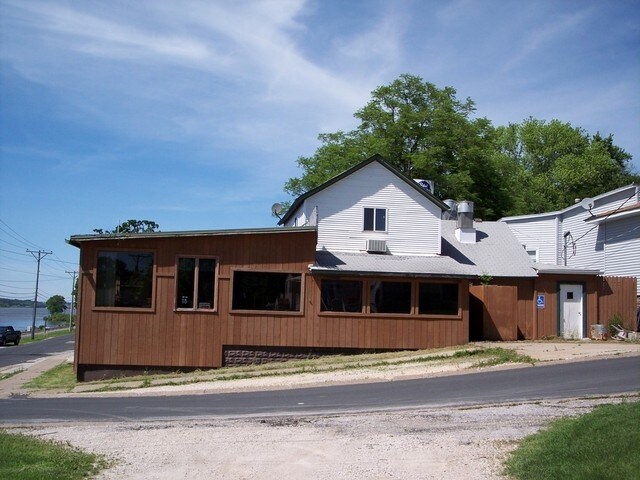
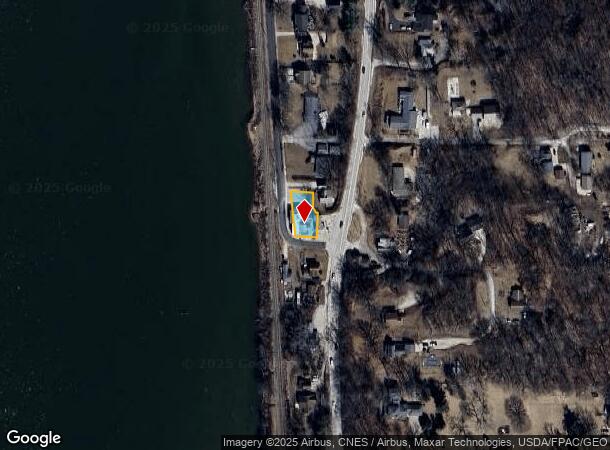
Property Record
708 S Main St, Port Byron, IL 61275
NEARBY LISTINGS FOR SALE OR LEASE
-
-
View all Port Byron listings for sale on LoopNet.com
Property Detail
708 S Main St
Davenport-Moline-Rock Island, IA-IL
Assessors Plat 1861
04-36-101-003
SUPVR ASST MAP LOT 102 SHEET 17
Commercialnec
Rock Island
X
Illinois
19163C0402G
102
2024
0.11 AC
2024
Outlying Rock Island Cnty
020102
Davenport/Moline/Rock Island
3,277 SF
DEMOGRAPHICS near 708 S Main St
1 Mile
3 Mile
5 Mile
2024 Total Population
2,563
8,169
14,140
2029 Population
2,520
7,961
13,741
Pop Growth 2024-2029
(1.68%)
(2.55%)
(2.82%)
Average Age
41
42
42
2024 Total Households
1,018
3,248
5,400
HH Growth 2024-2029
(1.77%)
(2.62%)
(2.96%)
Median Household Inc
$77,616
$82,552
$88,462
Avg Household Size
2.50
2.50
2.50
2024 Avg HH Vehicles
2.00
2.00
2.00
Median Home Value
$243,010
$264,729
$265,452
Median Year Built
1975
1977
1976
Nearby Places
Map Layers
Map Styles
 Street
 Aerial
- Restaurants
- Banks
- Shops
- Fitness
- Groceries
PUBLIC TRANSPORTATION
AIRPORT
Quad Cities International
DRIVE
WALK
Distance
Quad Cities International
29 min
17.6 mi
Freight Ports
Port Milwaukee
DRIVE
WALK
Distance
Port Milwaukee
226 min
201.0 mi
Nearby Properties
Address
Land Use
TOTAL SIZE
Lot Size
Zoning
Address
Land Use
TOTAL SIZE
Lot Size
Zoning
162,688 SF
57.89 AC
Address
Land Use
TOTAL SIZE
Lot Size
Zoning
3,623 SF
2.54 AC
Address
Land Use
TOTAL SIZE
Lot Size
Zoning
913 SF
8.44 AC
Address
Land Use
TOTAL SIZE
Lot Size
Zoning
27,365 SF
3.14 AC
Address
Land Use
TOTAL SIZE
Lot Size
Zoning
63,272 SF
15.49 AC
Address
Land Use
TOTAL SIZE
Lot Size
Zoning
11,960 SF
7.23 AC
Address
Land Use
TOTAL SIZE
Lot Size
Zoning
54,773 SF
12.64 AC
Address
Land Use
TOTAL SIZE
Lot Size
Zoning
13,621 SF
2.25 AC
Address
Land Use
TOTAL SIZE
Lot Size
Zoning
5,840 SF
2.26 AC
Address
Land Use
TOTAL SIZE
Lot Size
Zoning
9,601 SF
15.84 AC
Address
Land Use
TOTAL SIZE
Lot Size
Zoning
35,925 SF
2.23 AC
Address
Land Use
TOTAL SIZE
Lot Size
Zoning
7,455 SF
1.48 AC
Address
Land Use
TOTAL SIZE
Lot Size
Zoning
11,504 SF
2.10 AC
Address
Land Use
TOTAL SIZE
Lot Size
Zoning
13,757 SF
0.83 AC
Address
Land Use
TOTAL SIZE
Lot Size
Zoning
10,460 SF
0.50 AC
Address
Land Use
TOTAL SIZE
Lot Size
Zoning
5,195 SF
0.50 AC
Address
Land Use
TOTAL SIZE
Lot Size
Zoning
2,650 SF
1.48 AC
Address
Land Use
TOTAL SIZE
Lot Size
Zoning
2,368 SF
1.13 AC
Address
Land Use
TOTAL SIZE
Lot Size
Zoning
8,748 SF
1.79 AC
Address
Land Use
TOTAL SIZE
Lot Size
Zoning
4,264 SF
0.66 AC
Address
Land Use
TOTAL SIZE
Lot Size
Zoning
7,365 SF
0.66 AC
Address
Land Use
TOTAL SIZE
Lot Size
Zoning
5,400 SF
7.97 AC
Address
Land Use
TOTAL SIZE
Lot Size
Zoning
10.59 AC
PB
Address
Land Use
TOTAL SIZE
Lot Size
Zoning
2,322 SF
0.65 AC
Address
Land Use
TOTAL SIZE
Lot Size
Zoning
7,774 SF
0.62 AC
Address
Land Use
TOTAL SIZE
Lot Size
Zoning
7,920 SF
1.87 AC
Address
Land Use
TOTAL SIZE
Lot Size
Zoning
5,876 SF
1.09 AC
Address
Land Use
TOTAL SIZE
Lot Size
Zoning
4,973 SF
0.09 AC
Address
Land Use
TOTAL SIZE
Lot Size
Zoning
3,342 SF
0.10 AC
Address
Land Use
TOTAL SIZE
Lot Size
Zoning
14,400 SF
3.03 AC
The World's #1 Commercial Real Estate Marketplace
Connect with us
© 2025 CoStar Group
The information above has been obtained from sources believed reliable. While we do not doubt its accuracy we have not verified it and make no guarantee, warranty or representation about it. It is your responsibility to independently confirm its accuracy and completeness. Any projections, opinions, assumptions, or estimates used are for example only and do not represent the current or future performance of the property. The value of this transaction to you depends on tax and other factors which should be evaluated by your tax, financial, and legal advisors. You and your advisors should conduct a careful, independent investigation of the property to determine to your satisfaction the suitability of the property for your needs.