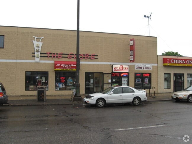
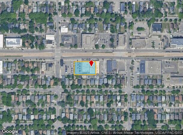
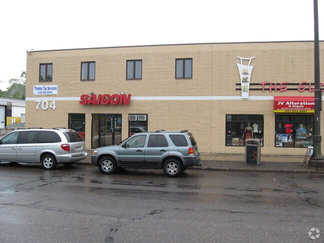
Property Record
708 University Ave W, Saint Paul, MN 55104
NEARBY LISTINGS FOR SALE OR LEASE
Property Detail
708 University Ave W
Minneapolis-St. Paul-Bloomington, MN-WI
Chute Brothers Division,No. 8
35-29-23-41-0217
CHUTE BROTHERS DIVISION,NO. 8 LOTS 8 THRU LOT 12
Stripcommercialcenter
Ramsey
X
Minnesota
27053C0400F
8,12
2024
0.56 AC
2025
St Paul
033400
Minneapolis/St Paul
12,684 SF
DEMOGRAPHICS near 708 University Ave W
1 Mile
3 Mile
5 Mile
2024 Total Population
28,404
169,326
372,961
2029 Population
27,667
164,959
364,558
Pop Growth 2024-2029
(2.59%)
(2.58%)
(2.25%)
Average Age
35
37
38
2024 Total Households
10,610
70,573
151,807
HH Growth 2024-2029
(2.83%)
(2.62%)
(2.30%)
Median Household Inc
$56,743
$66,720
$67,784
Avg Household Size
2.50
2.20
2.30
2024 Avg HH Vehicles
1.00
1.00
2.00
Median Home Value
$261,852
$286,454
$293,694
Median Year Built
1948
1948
1956
Nearby Places
- Restaurants
- Banks
- Shops
- Fitness
- Groceries
PUBLIC TRANSPORTATION
TRANSIT/SUBWAY
Dale St Station (METRO Green Line - Metro Transit)
DRIVE
WALK
Distance
Dale St Station (METRO Green Line - Metro Transit)
0 min
3 min
0.2 mi
Victoria St Station (METRO Green Line - Metro Transit)
DRIVE
WALK
Distance
Victoria St Station (METRO Green Line - Metro Transit)
2 min
7 min
0.4 mi
Western Ave Station (METRO Green Line - Metro Transit)
DRIVE
WALK
Distance
Western Ave Station (METRO Green Line - Metro Transit)
2 min
13 min
0.7 mi
Lexington Pkwy Station (METRO Green Line - Metro Transit)
DRIVE
WALK
Distance
Lexington Pkwy Station (METRO Green Line - Metro Transit)
3 min
17 min
0.9 mi
COMMUTER RAIL
St. Paul-Minneapolis (Empire Builder - Amtrak)
DRIVE
WALK
Distance
St. Paul-Minneapolis (Empire Builder - Amtrak)
6 min
2.7 mi
Target Field Station (Northstar Corridor - Northstar Commuter Rail)
DRIVE
WALK
Distance
Target Field Station (Northstar Corridor - Northstar Commuter Rail)
17 min
8.6 mi
AIRPORT
Minneapolis-St Paul International/Wold-Chamberlain
DRIVE
WALK
Distance
Minneapolis-St Paul International/Wold-Chamberlain
18 min
10.8 mi
Freight Ports
Port Milwaukee
DRIVE
WALK
Distance
Port Milwaukee
366 min
331.3 mi
Nearby Properties
Address
Land Use
TOTAL SIZE
Lot Size
Zoning
Address
Land Use
TOTAL SIZE
Lot Size
Zoning
384,515 SF
18.04 AC
Address
Land Use
TOTAL SIZE
Lot Size
Zoning
84,316 SF
40.83 AC
Address
Land Use
TOTAL SIZE
Lot Size
Zoning
384,515 SF
1.33 AC
Address
Land Use
TOTAL SIZE
Lot Size
Zoning
582,896 SF
14 AC
Address
Land Use
TOTAL SIZE
Lot Size
Zoning
825,463 SF
7.04 AC
Address
Land Use
TOTAL SIZE
Lot Size
Zoning
124,932 SF
9.68 AC
Address
Land Use
TOTAL SIZE
Lot Size
Zoning
63.12 AC
Address
Land Use
TOTAL SIZE
Lot Size
Zoning
646,900 SF
7.66 AC
Address
Land Use
TOTAL SIZE
Lot Size
Zoning
32,854 SF
5.55 AC
Address
Land Use
TOTAL SIZE
Lot Size
Zoning
404,491 SF
27.01 AC
Address
Land Use
TOTAL SIZE
Lot Size
Zoning
18.24 AC
Address
Land Use
TOTAL SIZE
Lot Size
Zoning
408.23 AC
Address
Land Use
TOTAL SIZE
Lot Size
Zoning
420,177 SF
2.13 AC
Address
Land Use
TOTAL SIZE
Lot Size
Zoning
395,419 SF
2.73 AC
Address
Land Use
TOTAL SIZE
Lot Size
Zoning
3,200 SF
0.14 AC
Address
Land Use
TOTAL SIZE
Lot Size
Zoning
516,325 SF
16.81 AC
Address
Land Use
TOTAL SIZE
Lot Size
Zoning
759,622 SF
2.66 AC
Address
Land Use
TOTAL SIZE
Lot Size
Zoning
786,042 SF
2.10 AC
Address
Land Use
TOTAL SIZE
Lot Size
Zoning
643,305 SF
1.93 AC
Address
Land Use
TOTAL SIZE
Lot Size
Zoning
7.41 AC
Address
Land Use
TOTAL SIZE
Lot Size
Zoning
4,808 SF
269.81 AC
Address
Land Use
TOTAL SIZE
Lot Size
Zoning
793,465 SF
1.93 AC
Address
Land Use
TOTAL SIZE
Lot Size
Zoning
68,748 SF
21.59 AC
Address
Land Use
TOTAL SIZE
Lot Size
Zoning
3,050 SF
58.60 AC
Address
Land Use
TOTAL SIZE
Lot Size
Zoning
18,630 SF
22.02 AC
Address
Land Use
TOTAL SIZE
Lot Size
Zoning
276,144 SF
347.68 AC
Address
Land Use
TOTAL SIZE
Lot Size
Zoning
160,800 SF
5.05 AC
Address
Land Use
TOTAL SIZE
Lot Size
Zoning
393,443 SF
3.75 AC
Address
Land Use
TOTAL SIZE
Lot Size
Zoning
260,739 SF
3.04 AC
Address
Land Use
TOTAL SIZE
Lot Size
Zoning
445,437 SF
7.80 AC
The World's #1 Commercial Real Estate Marketplace
Connect with us
© 2025 CoStar Group
The information above has been obtained from sources believed reliable. While we do not doubt its accuracy we have not verified it and make no guarantee, warranty or representation about it. It is your responsibility to independently confirm its accuracy and completeness. Any projections, opinions, assumptions, or estimates used are for example only and do not represent the current or future performance of the property. The value of this transaction to you depends on tax and other factors which should be evaluated by your tax, financial, and legal advisors. You and your advisors should conduct a careful, independent investigation of the property to determine to your satisfaction the suitability of the property for your needs.