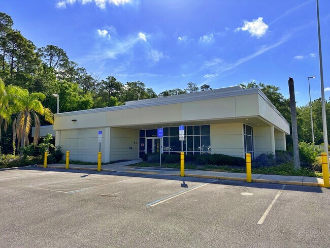
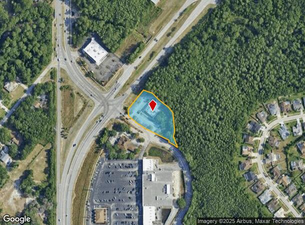
Property Record
7080 Mitchell Blvd, New Port Richey, FL 34655

NEARBY LISTINGS FOR SALE OR LEASE
Property Detail
7080 Mitchell Blvd
Tampa-St. Petersburg-Clearwater, FL
Major Corner
34-26-16-0000-00500-0060
COM AT SW COR OF SECTION TH N00DG 23 38E 2610.38 FT TH S89DG 36 22E 438.63 FT FOR POB TH ALG ARC OF CURVE RIGHT RADIUS 1510 FT CHD N38DG 59 31E 102.34 FT TH N40DG 56 03E 66.76 FT TH S71DG 28 43E 62.47 FT TH S46DG 31 15 E 68.45 FT TH S50DG 33 40E 81.7
Financialbuilding
Pasco
AE
Florida
12103C0037H
6
2024
1.58 AC
2025
Pasco County
031507
Tampa/St Petersburg
4,470 SF
DEMOGRAPHICS near 7080 Mitchell Blvd
1 Mile
3 Mile
5 Mile
2024 Total Population
5,608
57,308
167,896
2029 Population
6,732
67,959
196,440
Pop Growth 2024-2029
+ 20.04%
+ 18.59%
+ 17.00%
Average Age
43
42
45
2024 Total Households
2,068
23,197
71,878
HH Growth 2024-2029
+ 19.92%
+ 18.75%
+ 17.02%
Median Household Inc
$99,180
$53,832
$52,191
Avg Household Size
2.60
2.40
2.30
2024 Avg HH Vehicles
2.00
2.00
2.00
Median Home Value
$333,637
$211,976
$220,114
Median Year Built
1996
1983
1982
Nearby Places
Map Layers
Map Styles
 Street
 Aerial
- Restaurants
- Banks
- Shops
- Fitness
- Groceries
PUBLIC TRANSPORTATION
AIRPORT
Tampa International
DRIVE
WALK
Distance
Tampa International
41 min
23.7 mi
St Pete-Clearwater International
DRIVE
WALK
Distance
St Pete-Clearwater International
42 min
23.8 mi
Freight Ports
Port of Tampa Bay
DRIVE
WALK
Distance
Port of Tampa Bay
55 min
32.1 mi
Nearby Properties
Address
Land Use
TOTAL SIZE
Lot Size
Zoning
Address
Land Use
TOTAL SIZE
Lot Size
Zoning
384,700 SF
18.90 AC
MF3
Address
Land Use
TOTAL SIZE
Lot Size
Zoning
403,054 SF
117.69 AC
MPUD
Address
Land Use
TOTAL SIZE
Lot Size
Zoning
314,948 SF
55.04 AC
MPUD
Address
Land Use
TOTAL SIZE
Lot Size
Zoning
333,044 SF
25.64 AC
R4
Address
Land Use
TOTAL SIZE
Lot Size
Zoning
143,332 SF
17.40 AC
C2
Address
Land Use
TOTAL SIZE
Lot Size
Zoning
113,034 SF
15.21 AC
MPUD
Address
Land Use
TOTAL SIZE
Lot Size
Zoning
193,971 SF
4.50 AC
C1
Address
Land Use
TOTAL SIZE
Lot Size
Zoning
116,607 SF
3.88 AC
MPUD
Address
Land Use
TOTAL SIZE
Lot Size
Zoning
135,600 SF
13.34 AC
MF1
Address
Land Use
TOTAL SIZE
Lot Size
Zoning
55,440 SF
41.22 AC
RPD05
Address
Land Use
TOTAL SIZE
Lot Size
Zoning
70,248 SF
27.90 AC
R4
Address
Land Use
TOTAL SIZE
Lot Size
Zoning
89,242 SF
14.28 AC
MPUD
Address
Land Use
TOTAL SIZE
Lot Size
Zoning
217,376 SF
22.12 AC
C2
Address
Land Use
TOTAL SIZE
Lot Size
Zoning
121,869 SF
4.72 AC
C2
Address
Land Use
TOTAL SIZE
Lot Size
Zoning
112,703 SF
8.43 AC
C2
Address
Land Use
TOTAL SIZE
Lot Size
Zoning
77,900 SF
10.52 AC
C2
Address
Land Use
TOTAL SIZE
Lot Size
Zoning
85,600 SF
13.40 AC
C2
Address
Land Use
TOTAL SIZE
Lot Size
Zoning
89,308 SF
0.58 AC
C2
Address
Land Use
TOTAL SIZE
Lot Size
Zoning
80,212 SF
6.64 AC
Address
Land Use
TOTAL SIZE
Lot Size
Zoning
75,844 SF
2.75 AC
C2
Address
Land Use
TOTAL SIZE
Lot Size
Zoning
26,743 SF
7.32 AC
RPD05
Address
Land Use
TOTAL SIZE
Lot Size
Zoning
93,304 SF
18.82 AC
MF1
Address
Land Use
TOTAL SIZE
Lot Size
Zoning
133,304 SF
13.48 AC
C2
Address
Land Use
TOTAL SIZE
Lot Size
Zoning
74,641 SF
9.20 AC
C2
Address
Land Use
TOTAL SIZE
Lot Size
Zoning
81,272 SF
47.25 AC
MF2
Address
Land Use
TOTAL SIZE
Lot Size
Zoning
45,674 SF
4.21 AC
Address
Land Use
TOTAL SIZE
Lot Size
Zoning
53,055 SF
5.71 AC
C2
Address
Land Use
TOTAL SIZE
Lot Size
Zoning
55,165 SF
8.90 AC
C2
Address
Land Use
TOTAL SIZE
Lot Size
Zoning
50,190 SF
3 AC
MPUD
The World's #1 Commercial Real Estate Marketplace
Connect with us
© 2025 CoStar Group
The information above has been obtained from sources believed reliable. While we do not doubt its accuracy we have not verified it and make no guarantee, warranty or representation about it. It is your responsibility to independently confirm its accuracy and completeness. Any projections, opinions, assumptions, or estimates used are for example only and do not represent the current or future performance of the property. The value of this transaction to you depends on tax and other factors which should be evaluated by your tax, financial, and legal advisors. You and your advisors should conduct a careful, independent investigation of the property to determine to your satisfaction the suitability of the property for your needs.