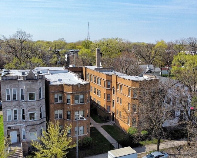
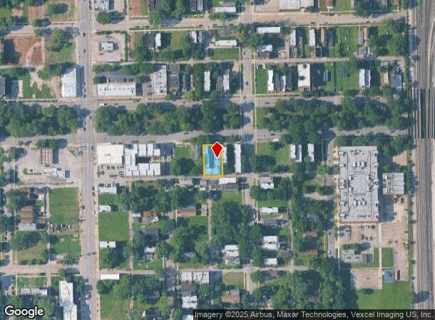
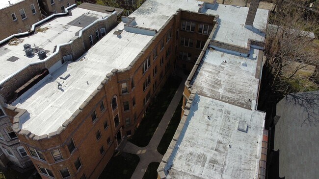
Property Record
709 W Garfield Blvd, Chicago, IL 60621

NEARBY LISTINGS FOR SALE OR LEASE
-
-
-
-
-
-
-
-
-
-
-
-
-
-
-
-
-
-
-
-
-
-
No Photo
-
-
-
-
-
-
-
-
-
View all Chicago listings for sale on LoopNet.com
Property Detail
709 W Garfield Blvd
Chicago-Naperville-Elgin, IL-IN-WI
Gardners 55Th
20-16-101-002-0000
(GARDNERS)(55TH) ST BLVD ADD IN NW SEC 16-38-14
Apartment
Cook
X
Illinois
17031C0520J
4,5
2023
0.22 AC
2024
Englewood
834700
Chicago
16,548 SF
DEMOGRAPHICS near 709 W Garfield Blvd
1 Mile
3 Mile
5 Mile
2024 Total Population
17,605
303,582
732,221
2029 Population
16,784
289,268
696,124
Pop Growth 2024-2029
(4.66%)
(4.72%)
(4.93%)
Average Age
37
37
38
2024 Total Households
6,272
116,355
279,803
HH Growth 2024-2029
(4.96%)
(4.69%)
(4.91%)
Median Household Inc
$26,691
$35,963
$44,205
Avg Household Size
2.60
2.50
2.50
2024 Avg HH Vehicles
1.00
1.00
1.00
Median Home Value
$148,577
$221,933
$226,535
Median Year Built
1948
1948
1949
Nearby Places
Map Layers
Map Styles
 Street
 Aerial
- Restaurants
- Banks
- Shops
- Fitness
- Groceries
PUBLIC TRANSPORTATION
TRANSIT/SUBWAY
Garfield Station (Red Line) (Red Line - Chicago Transit Authority "L" Trains (The "L"))
DRIVE
WALK
Distance
Garfield Station (Red Line) (Red Line - Chicago Transit Authority "L" Trains (The "L"))
7 min
14 min
0.7 mi
COMMUTER RAIL
35Th St. - Lou Jones (Rock Island - Metra)
DRIVE
WALK
Distance
35Th St. - Lou Jones (Rock Island - Metra)
6 min
3.3 mi
59Th Street (University Of Chicago) Station (Metra Electric Line - Northeast Illinois Regional Commuter Railroad (Metra))
DRIVE
WALK
Distance
59Th Street (University Of Chicago) Station (Metra Electric Line - Northeast Illinois Regional Commuter Railroad (Metra))
7 min
3.5 mi
AIRPORT
Chicago Midway International
DRIVE
WALK
Distance
Chicago Midway International
11 min
5.8 mi
Chicago O'Hare International
DRIVE
WALK
Distance
Chicago O'Hare International
38 min
24.1 mi
Freight Ports
Port Milwaukee
DRIVE
WALK
Distance
Port Milwaukee
115 min
92.4 mi
SALE & LEASE HISTORY
LISTING DATE
SALE/LEASE

Mar 02, 2023
For Sale
Jul 14, 2021
For Sale
Nearby Properties
Address
Land Use
TOTAL SIZE
Lot Size
Zoning
Address
Land Use
TOTAL SIZE
Lot Size
Zoning
134,800 SF
2.53 AC
PD 1273
Address
Land Use
TOTAL SIZE
Lot Size
Zoning
0.91 AC
PD 1177
Address
Land Use
TOTAL SIZE
Lot Size
Zoning
136,720 SF
0.54 AC
PD 1
Address
Land Use
TOTAL SIZE
Lot Size
Zoning
2.65 AC
PD 38
Address
Land Use
TOTAL SIZE
Lot Size
Zoning
475,000 SF
14.01 AC
PMD 8
Address
Land Use
TOTAL SIZE
Lot Size
Zoning
304,685 SF
1.11 AC
PD 1218
Address
Land Use
TOTAL SIZE
Lot Size
Zoning
0.84 AC
B1-3
Address
Land Use
TOTAL SIZE
Lot Size
Zoning
633,057 SF
34.96 AC
PMD 8
Address
Land Use
TOTAL SIZE
Lot Size
Zoning
7,200 SF
0.22 AC
B3-3
Address
Land Use
TOTAL SIZE
Lot Size
Zoning
156,800 SF
2.65 AC
PD 38
Address
Land Use
TOTAL SIZE
Lot Size
Zoning
PD 43
Address
Land Use
TOTAL SIZE
Lot Size
Zoning
794,288 SF
6.53 AC
PD 41
Address
Land Use
TOTAL SIZE
Lot Size
Zoning
283,180 SF
1.41 AC
M2-3
Address
Land Use
TOTAL SIZE
Lot Size
Zoning
0.73 AC
PD 1072
Address
Land Use
TOTAL SIZE
Lot Size
Zoning
151,303 SF
0.88 AC
PD 568
Address
Land Use
TOTAL SIZE
Lot Size
Zoning
1.65 AC
B2-3
Address
Land Use
TOTAL SIZE
Lot Size
Zoning
PD 43
Address
Land Use
TOTAL SIZE
Lot Size
Zoning
769,600 SF
PD 282
Address
Land Use
TOTAL SIZE
Lot Size
Zoning
460,333 SF
2.62 AC
C2-3
Address
Land Use
TOTAL SIZE
Lot Size
Zoning
88,000 SF
1.39 AC
RM-5,B1-3
Address
Land Use
TOTAL SIZE
Lot Size
Zoning
78,000 SF
0.62 AC
RM-5
Address
Land Use
TOTAL SIZE
Lot Size
Zoning
0.27 AC
PD 1
Address
Land Use
TOTAL SIZE
Lot Size
Zoning
7.47 AC
RT-4
Address
Land Use
TOTAL SIZE
Lot Size
Zoning
113,143 SF
PMD 8
Address
Land Use
TOTAL SIZE
Lot Size
Zoning
352,529 SF
12.77 AC
PMD 8
Address
Land Use
TOTAL SIZE
Lot Size
Zoning
283,228 SF
14.47 AC
PMD 8
Address
Land Use
TOTAL SIZE
Lot Size
Zoning
130,785 SF
2.27 AC
PD 1174
Address
Land Use
TOTAL SIZE
Lot Size
Zoning
13,700 SF
0.33 AC
B3-2
Address
Land Use
TOTAL SIZE
Lot Size
Zoning
117,557 SF
2.69 AC
B3-3
Address
Land Use
TOTAL SIZE
Lot Size
Zoning
168,120 SF
8.06 AC
PMD 8
The World's #1 Commercial Real Estate Marketplace
Connect with us
© 2025 CoStar Group
The information above has been obtained from sources believed reliable. While we do not doubt its accuracy we have not verified it and make no guarantee, warranty or representation about it. It is your responsibility to independently confirm its accuracy and completeness. Any projections, opinions, assumptions, or estimates used are for example only and do not represent the current or future performance of the property. The value of this transaction to you depends on tax and other factors which should be evaluated by your tax, financial, and legal advisors. You and your advisors should conduct a careful, independent investigation of the property to determine to your satisfaction the suitability of the property for your needs.