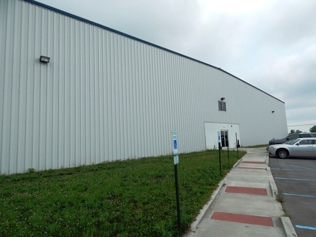
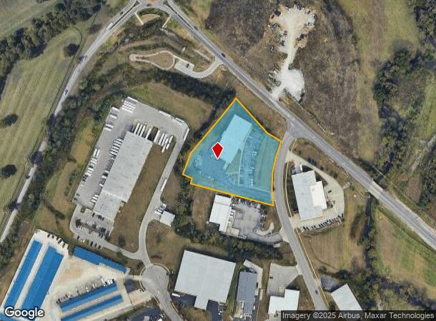
Property Record
709 Miles Point Way, Lexington, KY 40510

NEARBY LISTINGS FOR SALE OR LEASE
Property Detail
709 Miles Point Way
Lexington-Fayette, KY
Santa Barbara
26144100
N-928 SANTA BARBARA LOT 1; BOOK: 3607 PAGE: 170
Multipleuses
Fayette
X
Kentucky
2100670108E
1
2025
2.63 AC
2025
West Lexington/Fayette
003702
Lexington/Fayette
16,296 SF
DEMOGRAPHICS near 709 Miles Point Way
1 Mile
3 Mile
5 Mile
2024 Total Population
2,023
52,993
138,915
2029 Population
2,047
53,440
139,497
Pop Growth 2024-2029
+ 1.19%
+ 0.84%
+ 0.42%
Average Age
36
37
37
2024 Total Households
769
21,669
56,730
HH Growth 2024-2029
+ 1.17%
+ 0.77%
+ 0.47%
Median Household Inc
$52,500
$55,259
$55,615
Avg Household Size
2.50
2.30
2.20
2024 Avg HH Vehicles
1.00
2.00
2.00
Median Home Value
$168,934
$205,463
$242,536
Median Year Built
1980
1990
1975
Nearby Places
Map Layers
Map Styles
 Street
 Aerial
- Restaurants
- Banks
- Shops
- Fitness
- Groceries
PUBLIC TRANSPORTATION
AIRPORT
Blue Grass
DRIVE
WALK
Distance
Blue Grass
13 min
6.9 mi
Freight Ports
Port of Toledo
DRIVE
WALK
Distance
Port of Toledo
335 min
286.7 mi
SALE & LEASE HISTORY
LISTING DATE
SALE/LEASE

Jan 15, 2018
For Sale
Nearby Properties
Address
Land Use
TOTAL SIZE
Lot Size
Zoning
Address
Land Use
TOTAL SIZE
Lot Size
Zoning
6,173 SF
301.57 AC
A-R
Address
Land Use
TOTAL SIZE
Lot Size
Zoning
1,344 SF
150.76 AC
A-U
Address
Land Use
TOTAL SIZE
Lot Size
Zoning
8,078 SF
10.61 AC
R-5
Address
Land Use
TOTAL SIZE
Lot Size
Zoning
384,037 SF
9.52 AC
P-1
Address
Land Use
TOTAL SIZE
Lot Size
Zoning
2,545 SF
14 AC
R-4
Address
Land Use
TOTAL SIZE
Lot Size
Zoning
Address
Land Use
TOTAL SIZE
Lot Size
Zoning
9,774 SF
798.32 AC
A-R
Address
Land Use
TOTAL SIZE
Lot Size
Zoning
8,880 SF
7.39 AC
R-4
Address
Land Use
TOTAL SIZE
Lot Size
Zoning
14,292 SF
11.32 AC
R-4
Address
Land Use
TOTAL SIZE
Lot Size
Zoning
2,480 SF
9.12 AC
R-3
Address
Land Use
TOTAL SIZE
Lot Size
Zoning
23,042 SF
8.90 AC
R-4
Address
Land Use
TOTAL SIZE
Lot Size
Zoning
210 SF
46.68 AC
M-1P
Address
Land Use
TOTAL SIZE
Lot Size
Zoning
107,473 SF
17 AC
A-U
Address
Land Use
TOTAL SIZE
Lot Size
Zoning
78,675 SF
2.12 AC
P-1
Address
Land Use
TOTAL SIZE
Lot Size
Zoning
206,496 SF
5.57 AC
R-5
Address
Land Use
TOTAL SIZE
Lot Size
Zoning
2,864 SF
7.34 AC
R-3
Address
Land Use
TOTAL SIZE
Lot Size
Zoning
16.93 AC
R-3
Address
Land Use
TOTAL SIZE
Lot Size
Zoning
94,930 SF
15.03 AC
R-1D
Address
Land Use
TOTAL SIZE
Lot Size
Zoning
255,490 SF
55.45 AC
I-1
Address
Land Use
TOTAL SIZE
Lot Size
Zoning
9.05 AC
R-3
Address
Land Use
TOTAL SIZE
Lot Size
Zoning
88,216 SF
15 AC
R-1C
Address
Land Use
TOTAL SIZE
Lot Size
Zoning
187,120 SF
17.52 AC
I-1
Address
Land Use
TOTAL SIZE
Lot Size
Zoning
85,491 SF
8 AC
R-1D
Address
Land Use
TOTAL SIZE
Lot Size
Zoning
236,150 SF
17.83 AC
R-1D
Address
Land Use
TOTAL SIZE
Lot Size
Zoning
210,498 SF
18.36 AC
I-1
Address
Land Use
TOTAL SIZE
Lot Size
Zoning
73,236 SF
5.35 AC
R-4
Address
Land Use
TOTAL SIZE
Lot Size
Zoning
110,272 SF
3.95 AC
R-5
Address
Land Use
TOTAL SIZE
Lot Size
Zoning
95,268 SF
6.57 AC
R-4
Address
Land Use
TOTAL SIZE
Lot Size
Zoning
604,000 SF
60.19 AC
I-1
Address
Land Use
TOTAL SIZE
Lot Size
Zoning
110,272 SF
1.90 AC
R-5
The World's #1 Commercial Real Estate Marketplace
Connect with us
© 2025 CoStar Group
The information above has been obtained from sources believed reliable. While we do not doubt its accuracy we have not verified it and make no guarantee, warranty or representation about it. It is your responsibility to independently confirm its accuracy and completeness. Any projections, opinions, assumptions, or estimates used are for example only and do not represent the current or future performance of the property. The value of this transaction to you depends on tax and other factors which should be evaluated by your tax, financial, and legal advisors. You and your advisors should conduct a careful, independent investigation of the property to determine to your satisfaction the suitability of the property for your needs.