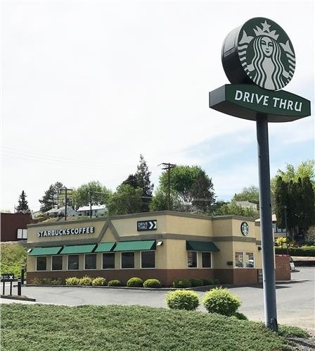
Property Record
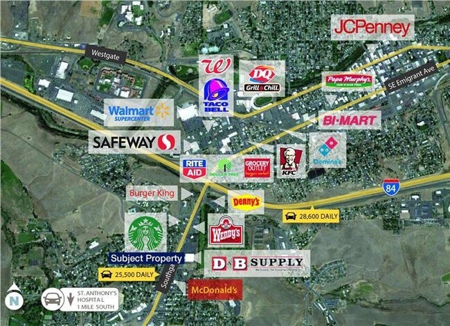
709 Southgate, Pendleton, OR 97801

Property Detail
709 Southgate
Commercialnec
Umatilla
C-3
Oregon
B and X Area of moderate flood hazard, usually the area between the limits of the 100-year and 500-year floods.
0.47 AC
2025
Oregon East Area
2025
Other Market Areas
950500
Hermiston-Pendleton, OR
2,121 SF
114505
NEARBY LISTINGS FOR SALE OR LEASE
DEMOGRAPHICS near 709 Southgate
1 mile
3 mile
5 mile
2024 Total Population
6,656
18,288
19,980
2029 Population
6,797
18,615
20,339
Pop Growth 2024-2029
+ 2.12%
+ 1.79%
+ 1.80%
Average Age
40
40
40
2024 Total Households
2,726
7,090
7,735
HH Growth 2024-2029
+ 2.24%
+ 2.05%
+ 2.04%
Median Household Inc
$64,147
$64,168
$64,200
Avg Household Size
2.40
2.30
2.30
2024 Avg HH Vehicles
2.00
2.00
2.00
Median Home Value
$299,999
$315,941
$316,576
Median Year Built
1973
1965
1966
Nearby Places
Map Layers
Map Styles
 Street
 Aerial
Transit
 Traffic
 Biking
Places
Listings with unknown addresses are not visible on the map
- Restaurants
- Banks
- Shops
- Fitness
- Groceries
PUBLIC TRANSPORTATION
AIRPORT
Walla Walla Regional
Drive
Walk
Distance
Walla Walla Regional
68 min
45.8 mi
SALE & LEASE HISTORY
LISTING DATE
SALE/LEASE

Jun 21, 2017
For Sale
Nearby Properties
Address
Land Use
TOTAL SIZE
Lot Size
Zoning
Address
Land Use
TOTAL SIZE
Lot Size
Zoning
103,530 SF
52.48 AC
C-3
Address
Land Use
TOTAL SIZE
Lot Size
Zoning
10 SF
35.87 AC
M-2
Address
Land Use
TOTAL SIZE
Lot Size
Zoning
106,632 SF
19.31 AC
M-1
Address
Land Use
TOTAL SIZE
Lot Size
Zoning
285,906 SF
150.74 AC
R2
Address
Land Use
TOTAL SIZE
Lot Size
Zoning
10 SF
6.35 AC
M-2
Address
Land Use
TOTAL SIZE
Lot Size
Zoning
196,708 SF
9.25 AC
R2
Address
Land Use
TOTAL SIZE
Lot Size
Zoning
37,130 SF
11.83 AC
R1
Address
Land Use
TOTAL SIZE
Lot Size
Zoning
10 SF
6.35 AC
M-2
Address
Land Use
TOTAL SIZE
Lot Size
Zoning
64,741 SF
5.39 AC
R-2
Address
Land Use
TOTAL SIZE
Lot Size
Zoning
50,523 SF
3.70 AC
C-1
Address
Land Use
TOTAL SIZE
Lot Size
Zoning
60,765 SF
1.41 AC
C-1
Address
Land Use
TOTAL SIZE
Lot Size
Zoning
164,864 SF
15.06 AC
C-1
Address
Land Use
TOTAL SIZE
Lot Size
Zoning
10 SF
6.21 AC
EFU
Address
Land Use
TOTAL SIZE
Lot Size
Zoning
10.15 AC
M-1
Address
Land Use
TOTAL SIZE
Lot Size
Zoning
36,504 SF
2.14 AC
C-3
Address
Land Use
TOTAL SIZE
Lot Size
Zoning
83,737 SF
7.07 AC
C-1
Address
Land Use
TOTAL SIZE
Lot Size
Zoning
10 SF
20.18 AC
M-1
Address
Land Use
TOTAL SIZE
Lot Size
Zoning
26,815 SF
2.22 AC
R3
Address
Land Use
TOTAL SIZE
Lot Size
Zoning
10 SF
10 AC
M-2
Address
Land Use
TOTAL SIZE
Lot Size
Zoning
55,740 SF
3.93 AC
C-1
Address
Land Use
TOTAL SIZE
Lot Size
Zoning
23,900 SF
1.58 AC
C-3
Address
Land Use
TOTAL SIZE
Lot Size
Zoning
100,000 SF
14.20 AC
C-1
Address
Land Use
TOTAL SIZE
Lot Size
Zoning
41,920 SF
4.01 AC
M-2
Address
Land Use
TOTAL SIZE
Lot Size
Zoning
10 SF
1.75 AC
R-1
Address
Land Use
TOTAL SIZE
Lot Size
Zoning
45,357 SF
1.44 AC
C-3
Address
Land Use
TOTAL SIZE
Lot Size
Zoning
136,207 SF
9 AC
C-2
Address
Land Use
TOTAL SIZE
Lot Size
Zoning
50,940 SF
3.28 AC
M-1
Address
Land Use
TOTAL SIZE
Lot Size
Zoning
29,352 SF
10.48 AC
R1
Address
Land Use
TOTAL SIZE
Lot Size
Zoning
43,480 SF
8.49 AC
R-2,M-1
Address
Land Use
TOTAL SIZE
Lot Size
Zoning
40,345 SF
1.44 AC
R-2
The World's #1 Commercial Real Estate Marketplace
Connect with us
© 2026 CoStar Group
The information above has been obtained from sources believed reliable. While we do not doubt its accuracy we have not verified it and make no guarantee, warranty or representation about it. It is your responsibility to independently confirm its accuracy and completeness. Any projections, opinions, assumptions, or estimates used are for example only and do not represent the current or future performance of the property. The value of this transaction to you depends on tax and other factors which should be evaluated by your tax, financial, and legal advisors. You and your advisors should conduct a careful, independent investigation of the property to determine to your satisfaction the suitability of the property for your needs.