Property Record
7098 Main St, Wade, NC 28395
NEARBY LISTINGS FOR SALE OR LEASE
-
-
View all Wade listings for sale on LoopNet.com
Property Detail
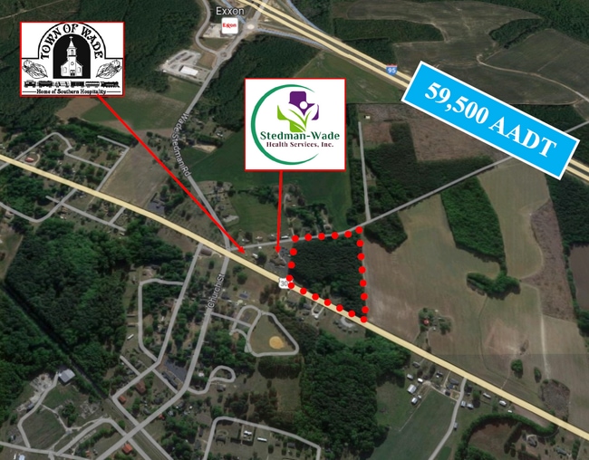
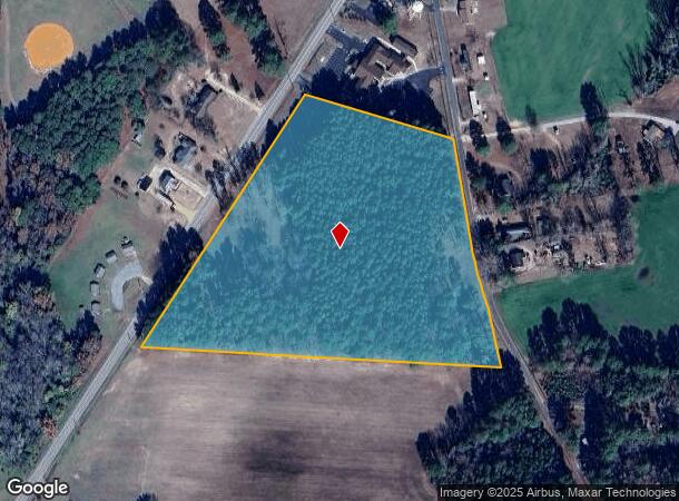
7098 Main St
Fayetteville, NC
Town Of Wade
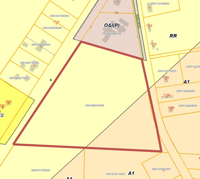
0581-02-6418
E O MCLAURIN SE:01 PL:0118-0198
Agriculturalland
Cumberland
X
North Carolina
3720058000J
6418
2025
11.93 AC
2025
East Fayetteville
002600
Fayetteville
DEMOGRAPHICS near 7098 Main St
1 Mile
3 Mile
5 Mile
2024 Total Population
519
1,538
4,956
2029 Population
499
1,494
4,908
Pop Growth 2024-2029
(3.85%)
(2.86%)
(0.97%)
Average Age
41
41
41
2024 Total Households
210
593
1,922
HH Growth 2024-2029
(3.81%)
(3.04%)
(1.04%)
Median Household Inc
$49,166
$60,082
$62,838
Avg Household Size
2.50
2.50
2.50
2024 Avg HH Vehicles
2.00
2.00
2.00
Median Home Value
$157,936
$169,252
$186,469
Median Year Built
1980
1983
1985
Nearby Places
Map Layers
Map Styles
 Street
 Aerial
- Restaurants
- Banks
- Shops
- Fitness
- Groceries
PUBLIC TRANSPORTATION
AIRPORT
Fayetteville Regional/Grannis Field
DRIVE
WALK
Distance
Fayetteville Regional/Grannis Field
25 min
16.6 mi
Freight Ports
Port of Wilmington
DRIVE
WALK
Distance
Port of Wilmington
136 min
96.1 mi
SALE & LEASE HISTORY
LISTING DATE
SALE/LEASE

Oct 11, 2023
For Sale
Nearby Properties
Address
Land Use
TOTAL SIZE
Lot Size
Zoning
Address
Land Use
TOTAL SIZE
Lot Size
Zoning
29,976 SF
12.71 AC
RR
Address
Land Use
TOTAL SIZE
Lot Size
Zoning
32,975 SF
23.90 AC
A1
Address
Land Use
TOTAL SIZE
Lot Size
Zoning
7,494 SF
31.66 AC
A1
Address
Land Use
TOTAL SIZE
Lot Size
Zoning
4,390 SF
3.59 AC
CP
Address
Land Use
TOTAL SIZE
Lot Size
Zoning
5,688 SF
169.31 AC
R30
Address
Land Use
TOTAL SIZE
Lot Size
Zoning
6,171 SF
4.57 AC
CP
Address
Land Use
TOTAL SIZE
Lot Size
Zoning
7,777 SF
9.03 AC
MP
Address
Land Use
TOTAL SIZE
Lot Size
Zoning
7,381 SF
1.13 AC
RR
Address
Land Use
TOTAL SIZE
Lot Size
Zoning
1.62 AC
CPCZ
Address
Land Use
TOTAL SIZE
Lot Size
Zoning
337.76 AC
A1
Address
Land Use
TOTAL SIZE
Lot Size
Zoning
43,000 SF
11.13 AC
M2
Address
Land Use
TOTAL SIZE
Lot Size
Zoning
9,642 SF
2 AC
O&I
Address
Land Use
TOTAL SIZE
Lot Size
Zoning
8,680 SF
5.39 AC
RR
Address
Land Use
TOTAL SIZE
Lot Size
Zoning
204 AC
A1
Address
Land Use
TOTAL SIZE
Lot Size
Zoning
228.61 AC
A1
Address
Land Use
TOTAL SIZE
Lot Size
Zoning
2,444 SF
13.03 AC
A1
Address
Land Use
TOTAL SIZE
Lot Size
Zoning
328.73 AC
A1
Address
Land Use
TOTAL SIZE
Lot Size
Zoning
204.17 AC
A1
Address
Land Use
TOTAL SIZE
Lot Size
Zoning
3,078 SF
1.36 AC
A1
Address
Land Use
TOTAL SIZE
Lot Size
Zoning
10,960 SF
4.21 AC
CPCZ
Address
Land Use
TOTAL SIZE
Lot Size
Zoning
188 AC
A1
Address
Land Use
TOTAL SIZE
Lot Size
Zoning
39.28 AC
A1
Address
Land Use
TOTAL SIZE
Lot Size
Zoning
154.23 AC
A1
Address
Land Use
TOTAL SIZE
Lot Size
Zoning
1,328 SF
71.24 AC
A1-AGRI DI
Address
Land Use
TOTAL SIZE
Lot Size
Zoning
6,269 SF
2.21 AC
R6A-RESIDE
Address
Land Use
TOTAL SIZE
Lot Size
Zoning
308.33 AC
A1
Address
Land Use
TOTAL SIZE
Lot Size
Zoning
104 AC
A1
Address
Land Use
TOTAL SIZE
Lot Size
Zoning
169.07 AC
A1
Address
Land Use
TOTAL SIZE
Lot Size
Zoning
9,025 SF
14.89 AC
RR
Address
Land Use
TOTAL SIZE
Lot Size
Zoning
380.89 AC
A1
The World's #1 Commercial Real Estate Marketplace
Connect with us
© 2026 CoStar Group
The information above has been obtained from sources believed reliable. While we do not doubt its accuracy we have not verified it and make no guarantee, warranty or representation about it. It is your responsibility to independently confirm its accuracy and completeness. Any projections, opinions, assumptions, or estimates used are for example only and do not represent the current or future performance of the property. The value of this transaction to you depends on tax and other factors which should be evaluated by your tax, financial, and legal advisors. You and your advisors should conduct a careful, independent investigation of the property to determine to your satisfaction the suitability of the property for your needs.