Property Record
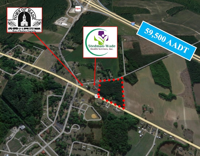
7098 Main St, Wade, NC 28395

Save to a Folder
{{folder.Name}}
{{folder.ListingIds.length}} Properties
{{folder.ListingIds.length}} Property
Create a New Folder
Property Detail
7098 Main St
Fayetteville, NC
E O MCLAURIN SE:01 PL:0118-0198
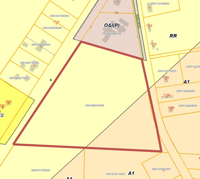
0581-02-6418
Cumberland
Agriculturalland
North Carolina
RR
6418
B and X Area of moderate flood hazard, usually the area between the limits of the 100-year and 500-year floods.
11.93 AC
2025
East Fayetteville
2025
Fayetteville
002600
NEARBY LISTINGS FOR SALE OR LEASE
-
-
View all Wade listings for sale on LoopNet.com
DEMOGRAPHICS near 7098 Main St
1 mile
3 mile
5 mile
2025 Total Population
561
1,673
5,262
2030 Population
555
1,660
5,294
Pop Growth 2025-2030
(1.07%)
(0.78%)
+ 0.61%
Average Age
41
41
41
2025 Total Households
228
650
2,051
HH Growth 2025-2030
(1.32%)
(0.77%)
+ 0.68%
Median Household Inc
$73,571
$74,903
$80,546
Avg Household Size
2.50
2.50
2.50
2025 Avg HH Vehicles
2.00
2.00
2.00
Median Home Value
$216,935
$236,187
$253,157
Median Year Built
1981
1984
1986
Nearby Places
Map Layers
Map Styles
 Street
 Aerial
Layers
 Traffic
 Biking
Places
Listings with unknown addresses are not visible on the map
- Restaurants
- Banks
- Shops
- Fitness
- Groceries
PUBLIC TRANSPORTATION
AIRPORT
Fayetteville Regional/Grannis Field
Drive
Walk
Distance
Fayetteville Regional/Grannis Field
26 min
16.9 mi
SALE & LEASE HISTORY
LISTING DATE
SALE/LEASE

Oct 11, 2023
For Sale
Nearby Properties
Address
Land Use
TOTAL SIZE
Lot Size
Zoning
Address
Land Use
TOTAL SIZE
Lot Size
Zoning
32,975 SF
23.90 AC
A1
Address
Land Use
TOTAL SIZE
Lot Size
Zoning
7,494 SF
31.66 AC
A1
Address
Land Use
TOTAL SIZE
Lot Size
Zoning
4,390 SF
3.59 AC
CP
Address
Land Use
TOTAL SIZE
Lot Size
Zoning
5,688 SF
169.31 AC
R30
Address
Land Use
TOTAL SIZE
Lot Size
Zoning
6,171 SF
4.57 AC
CP
Address
Land Use
TOTAL SIZE
Lot Size
Zoning
7,777 SF
9.03 AC
MP
Address
Land Use
TOTAL SIZE
Lot Size
Zoning
7,381 SF
1.13 AC
RR
Address
Land Use
TOTAL SIZE
Lot Size
Zoning
1.62 AC
CPCZ
Address
Land Use
TOTAL SIZE
Lot Size
Zoning
337.76 AC
A1
Address
Land Use
TOTAL SIZE
Lot Size
Zoning
43,000 SF
11.13 AC
M2
Address
Land Use
TOTAL SIZE
Lot Size
Zoning
9,642 SF
2 AC
O&I
Address
Land Use
TOTAL SIZE
Lot Size
Zoning
8,680 SF
5.39 AC
RR
Address
Land Use
TOTAL SIZE
Lot Size
Zoning
204 AC
A1
Address
Land Use
TOTAL SIZE
Lot Size
Zoning
228.61 AC
A1
Address
Land Use
TOTAL SIZE
Lot Size
Zoning
2,444 SF
13.03 AC
A1
Address
Land Use
TOTAL SIZE
Lot Size
Zoning
328.73 AC
A1
Address
Land Use
TOTAL SIZE
Lot Size
Zoning
204.17 AC
A1
Address
Land Use
TOTAL SIZE
Lot Size
Zoning
3,078 SF
1.36 AC
A1
Address
Land Use
TOTAL SIZE
Lot Size
Zoning
10,960 SF
4.21 AC
CPCZ
Address
Land Use
TOTAL SIZE
Lot Size
Zoning
188 AC
A1
Address
Land Use
TOTAL SIZE
Lot Size
Zoning
39.28 AC
A1
Address
Land Use
TOTAL SIZE
Lot Size
Zoning
154.23 AC
A1
Address
Land Use
TOTAL SIZE
Lot Size
Zoning
6,269 SF
2.21 AC
R6A-RESIDE
Address
Land Use
TOTAL SIZE
Lot Size
Zoning
308.33 AC
A1
Address
Land Use
TOTAL SIZE
Lot Size
Zoning
104 AC
A1
Address
Land Use
TOTAL SIZE
Lot Size
Zoning
169.07 AC
A1
Address
Land Use
TOTAL SIZE
Lot Size
Zoning
9,025 SF
14.89 AC
RR
Address
Land Use
TOTAL SIZE
Lot Size
Zoning
380.89 AC
A1
Address
Land Use
TOTAL SIZE
Lot Size
Zoning
1,606 SF
4 AC
A1
Address
Land Use
TOTAL SIZE
Lot Size
Zoning
31 AC
A1
The World's #1 Commercial Real Estate Marketplace
Connect with us
© 2026 CoStar Group
The information above has been obtained from sources believed reliable. While we do not doubt its accuracy we have not verified it and make no guarantee, warranty or representation about it. It is your responsibility to independently confirm its accuracy and completeness. Any projections, opinions, assumptions, or estimates used are for example only and do not represent the current or future performance of the property. The value of this transaction to you depends on tax and other factors which should be evaluated by your tax, financial, and legal advisors. You and your advisors should conduct a careful, independent investigation of the property to determine to your satisfaction the suitability of the property for your needs.