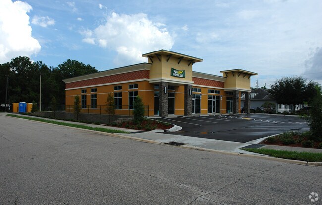
Property Record
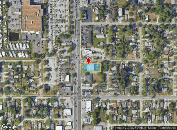
7099 66Th St N, Pinellas Park, FL 33781
NEARBY LISTINGS FOR SALE OR LEASE
Property Detail
7099 66Th St N
Tampa-St. Petersburg-Clearwater, FL
Pinellas Park 1St Add
29-30-16-71082-090-0150
PINELLAS PARK 1ST ADD BLK 90, LOTS 15 & 16 LESS RD R/W ADJ ON N & W TOGETHER WITH W 1/2 OF LOTS 1 & 2 & VAC 10FT ALLEY BTWN SD LOTS 1, 2, 15 & 16 PER O.R. 9088/346
Regionalshoppingcenterormallwithanchorstore
Pinellas
X
Florida
12103C0203J
15,16
2024
0.51 AC
2025
South Pinellas
024901
Tampa/St Petersburg
5,344 SF
DEMOGRAPHICS near 7099 66Th St N
1 Mile
3 Mile
5 Mile
2024 Total Population
13,689
109,017
260,155
2029 Population
13,652
109,247
260,744
Pop Growth 2024-2029
(0.27%)
+ 0.21%
+ 0.23%
Average Age
41
45
46
2024 Total Households
5,209
46,818
117,197
HH Growth 2024-2029
(0.56%)
+ 0.09%
+ 0.17%
Median Household Inc
$60,197
$56,103
$58,539
Avg Household Size
2.40
2.20
2.10
2024 Avg HH Vehicles
2.00
2.00
2.00
Median Home Value
$249,117
$225,123
$234,263
Median Year Built
1975
1973
1972
Nearby Places
Map Layers
Map Styles
 Street
 Aerial
- Restaurants
- Banks
- Shops
- Fitness
- Groceries
PUBLIC TRANSPORTATION
AIRPORT
St Pete-Clearwater International
DRIVE
WALK
Distance
St Pete-Clearwater International
21 min
9.0 mi
Tampa International
DRIVE
WALK
Distance
Tampa International
31 min
18.7 mi
Sarasota/Bradenton International
DRIVE
WALK
Distance
Sarasota/Bradenton International
60 min
40.2 mi
Nearby Properties
Address
Land Use
TOTAL SIZE
Lot Size
Zoning
Address
Land Use
TOTAL SIZE
Lot Size
Zoning
459,848 SF
19.74 AC
R6
Address
Land Use
TOTAL SIZE
Lot Size
Zoning
372,013 SF
10.10 AC
Address
Land Use
TOTAL SIZE
Lot Size
Zoning
738,882 SF
43.34 AC
Address
Land Use
TOTAL SIZE
Lot Size
Zoning
404,899 SF
35.35 AC
Address
Land Use
TOTAL SIZE
Lot Size
Zoning
358,681 SF
11.70 AC
Address
Land Use
TOTAL SIZE
Lot Size
Zoning
402,681 SF
18.40 AC
Address
Land Use
TOTAL SIZE
Lot Size
Zoning
206,685 SF
16.75 AC
RPD5
Address
Land Use
TOTAL SIZE
Lot Size
Zoning
267,649 SF
17.86 AC
Address
Land Use
TOTAL SIZE
Lot Size
Zoning
193,194 SF
13.53 AC
Address
Land Use
TOTAL SIZE
Lot Size
Zoning
360,137 SF
37.64 AC
AE
Address
Land Use
TOTAL SIZE
Lot Size
Zoning
172,600 SF
20.57 AC
Address
Land Use
TOTAL SIZE
Lot Size
Zoning
172,768 SF
15.05 AC
RPD20
Address
Land Use
TOTAL SIZE
Lot Size
Zoning
125,218 SF
13.51 AC
Address
Land Use
TOTAL SIZE
Lot Size
Zoning
297,508 SF
36.80 AC
Address
Land Use
TOTAL SIZE
Lot Size
Zoning
226,561 SF
24.34 AC
Address
Land Use
TOTAL SIZE
Lot Size
Zoning
116,358 SF
12.74 AC
Address
Land Use
TOTAL SIZE
Lot Size
Zoning
248,572 SF
15.22 AC
PSP
Address
Land Use
TOTAL SIZE
Lot Size
Zoning
145,047 SF
12.03 AC
Address
Land Use
TOTAL SIZE
Lot Size
Zoning
136,376 SF
15.11 AC
Address
Land Use
TOTAL SIZE
Lot Size
Zoning
49,898 SF
77.25 AC
Address
Land Use
TOTAL SIZE
Lot Size
Zoning
89,316 SF
9.24 AC
Address
Land Use
TOTAL SIZE
Lot Size
Zoning
171,859 SF
19.67 AC
C3
Address
Land Use
TOTAL SIZE
Lot Size
Zoning
119,580 SF
4.18 AC
Address
Land Use
TOTAL SIZE
Lot Size
Zoning
172,366 SF
11.41 AC
Address
Land Use
TOTAL SIZE
Lot Size
Zoning
137,240 SF
11.38 AC
RPD125
Address
Land Use
TOTAL SIZE
Lot Size
Zoning
151,193 SF
23.54 AC
Address
Land Use
TOTAL SIZE
Lot Size
Zoning
90,145 SF
3.46 AC
Address
Land Use
TOTAL SIZE
Lot Size
Zoning
159,218 SF
12.48 AC
Address
Land Use
TOTAL SIZE
Lot Size
Zoning
287,750 SF
24.57 AC
Address
Land Use
TOTAL SIZE
Lot Size
Zoning
159,726 SF
14.26 AC
The World's #1 Commercial Real Estate Marketplace
Connect with us
© 2025 CoStar Group
The information above has been obtained from sources believed reliable. While we do not doubt its accuracy we have not verified it and make no guarantee, warranty or representation about it. It is your responsibility to independently confirm its accuracy and completeness. Any projections, opinions, assumptions, or estimates used are for example only and do not represent the current or future performance of the property. The value of this transaction to you depends on tax and other factors which should be evaluated by your tax, financial, and legal advisors. You and your advisors should conduct a careful, independent investigation of the property to determine to your satisfaction the suitability of the property for your needs.