No Photo
Property Record
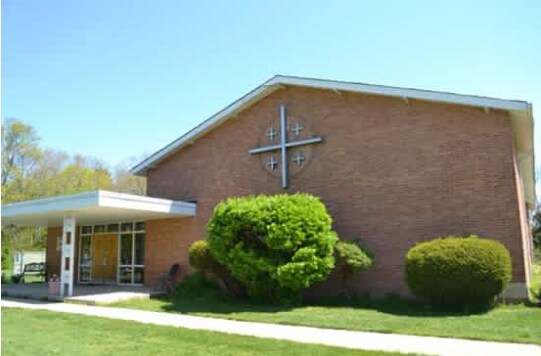
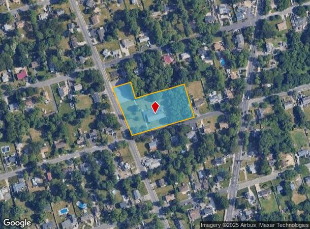
71 Calebs Pat Path, Central Islip, NY 11722
NEARBY LISTINGS FOR SALE OR LEASE
-
-
View all Central Islip listings for lease on LoopNet.com
Property Detail
71 Calebs Pat Path
Nassau County-Suffolk County, NY
Map Motor Parkway Acreage
0500-096-00-03-00-016-001
N011N00000000
Religious
Suffolk
X
New York
36103C0665H
300
0
2.06 AC
2024
Western Suffolk
145703
Long Island (New York)
DEMOGRAPHICS near 71 Calebs Pat Path
1 Mile
3 Mile
5 Mile
2024 Total Population
17,066
116,108
248,736
2029 Population
16,428
112,356
242,316
Pop Growth 2024-2029
(3.74%)
(3.23%)
(2.58%)
Average Age
36
37
39
2024 Total Households
3,833
28,952
72,799
HH Growth 2024-2029
(4.17%)
(3.36%)
(2.63%)
Median Household Inc
$100,131
$104,506
$115,852
Avg Household Size
3.90
3.60
3.20
2024 Avg HH Vehicles
2.00
2.00
2.00
Median Home Value
$386,983
$406,478
$459,201
Median Year Built
1965
1967
1966
Nearby Places
- Restaurants
- Banks
- Shops
- Fitness
- Groceries
PUBLIC TRANSPORTATION
COMMUTER RAIL
Central Islip Station (Ronkonkoma Branch - Long Island Rail Road)
DRIVE
WALK
Distance
Central Islip Station (Ronkonkoma Branch - Long Island Rail Road)
3 min
1.3 mi
Brentwood Station (Ronkonkoma Branch - Long Island Rail Road)
DRIVE
WALK
Distance
Brentwood Station (Ronkonkoma Branch - Long Island Rail Road)
6 min
2.2 mi
AIRPORT
Long Island MacArthur
DRIVE
WALK
Distance
Long Island MacArthur
18 min
7.9 mi
SALE & LEASE HISTORY
LISTING DATE
SALE/LEASE

Oct 27, 2016
For Lease
Nearby Properties
Address
Land Use
TOTAL SIZE
Lot Size
Zoning
Address
Land Use
TOTAL SIZE
Lot Size
Zoning
301 SF
3.70 AC
Address
Land Use
TOTAL SIZE
Lot Size
Zoning
97.50 AC
AAA
Address
Land Use
TOTAL SIZE
Lot Size
Zoning
194.82 AC
AAA
Address
Land Use
TOTAL SIZE
Lot Size
Zoning
57.30 AC
AAA
Address
Land Use
TOTAL SIZE
Lot Size
Zoning
22.22 AC
AA
Address
Land Use
TOTAL SIZE
Lot Size
Zoning
52.73 AC
AAA
Address
Land Use
TOTAL SIZE
Lot Size
Zoning
170.87 AC
AAA
Address
Land Use
TOTAL SIZE
Lot Size
Zoning
24.10 AC
A
Address
Land Use
TOTAL SIZE
Lot Size
Zoning
196.07 AC
AAA
Address
Land Use
TOTAL SIZE
Lot Size
Zoning
83.41 AC
Address
Land Use
TOTAL SIZE
Lot Size
Zoning
27.38 AC
Address
Land Use
TOTAL SIZE
Lot Size
Zoning
2.79 AC
Address
Land Use
TOTAL SIZE
Lot Size
Zoning
36.66 AC
NULL
Address
Land Use
TOTAL SIZE
Lot Size
Zoning
24.96 AC
Address
Land Use
TOTAL SIZE
Lot Size
Zoning
24.70 AC
AAA
Address
Land Use
TOTAL SIZE
Lot Size
Zoning
15.46 AC
PDDEC
Address
Land Use
TOTAL SIZE
Lot Size
Zoning
5,140 SF
23.39 AC
CA
Address
Land Use
TOTAL SIZE
Lot Size
Zoning
19.70 AC
A
Address
Land Use
TOTAL SIZE
Lot Size
Zoning
21.20 AC
AA
Address
Land Use
TOTAL SIZE
Lot Size
Zoning
15 AC
AA
Address
Land Use
TOTAL SIZE
Lot Size
Zoning
45.56 AC
Address
Land Use
TOTAL SIZE
Lot Size
Zoning
30.50 AC
A
Address
Land Use
TOTAL SIZE
Lot Size
Zoning
12.84 AC
NULL
Address
Land Use
TOTAL SIZE
Lot Size
Zoning
31.64 AC
Address
Land Use
TOTAL SIZE
Lot Size
Zoning
8.02 AC
NULL
Address
Land Use
TOTAL SIZE
Lot Size
Zoning
10.74 AC
Address
Land Use
TOTAL SIZE
Lot Size
Zoning
10.20 AC
B
Address
Land Use
TOTAL SIZE
Lot Size
Zoning
14.08 AC
Address
Land Use
TOTAL SIZE
Lot Size
Zoning
16.52 AC
AA
Address
Land Use
TOTAL SIZE
Lot Size
Zoning
10.90 AC
AAA
The World's #1 Commercial Real Estate Marketplace
Connect with us
© 2025 CoStar Group
The information above has been obtained from sources believed reliable. While we do not doubt its accuracy we have not verified it and make no guarantee, warranty or representation about it. It is your responsibility to independently confirm its accuracy and completeness. Any projections, opinions, assumptions, or estimates used are for example only and do not represent the current or future performance of the property. The value of this transaction to you depends on tax and other factors which should be evaluated by your tax, financial, and legal advisors. You and your advisors should conduct a careful, independent investigation of the property to determine to your satisfaction the suitability of the property for your needs.