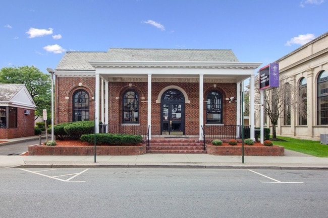
Property Record
71 Lafayette Ave, Suffern, NY 10901
NEARBY LISTINGS FOR SALE OR LEASE
Property Detail
71 Lafayette Ave
392607-054-035-0002-050-000-0000
12/16/81
Financialbuilding
Rockland
X
New York
34003C0057H
50.0
2023
0.17 AC
2024
Ramapo
011602
Northern New Jersey
656 SF
New York-Jersey City-White Plains, NY-NJ
DEMOGRAPHICS near 71 Lafayette Ave
1 Mile
3 Mile
5 Mile
2024 Total Population
8,804
40,877
126,671
2029 Population
8,714
40,901
126,296
Pop Growth 2024-2029
(1.02%)
+ 0.06%
(0.30%)
Average Age
40
42
36
2024 Total Households
3,302
15,534
38,562
HH Growth 2024-2029
(1.00%)
+ 0.04%
(0.22%)
Median Household Inc
$97,295
$106,296
$101,002
Avg Household Size
2.60
2.50
3.10
2024 Avg HH Vehicles
2.00
2.00
2.00
Median Home Value
$371,268
$483,214
$634,224
Median Year Built
1959
1976
1975
Nearby Places
- Restaurants
- Banks
- Shops
- Fitness
- Groceries
PUBLIC TRANSPORTATION
COMMUTER RAIL
Suffern (Bergen County/Port Jervis Line - NJ Transit Commuter Rail (NJ Transit), Main/Port Jervis Line - NJ Transit Commuter Rail (NJ Transit))
DRIVE
WALK
Distance
Suffern (Bergen County/Port Jervis Line - NJ Transit Commuter Rail (NJ Transit), Main/Port Jervis Line - NJ Transit Commuter Rail (NJ Transit))
1 min
6 min
0.3 mi
Mahwah (Bergen County/Port Jervis Line - NJ Transit Commuter Rail (NJ Transit), Main/Port Jervis Line - NJ Transit Commuter Rail (NJ Transit))
DRIVE
WALK
Distance
Mahwah (Bergen County/Port Jervis Line - NJ Transit Commuter Rail (NJ Transit), Main/Port Jervis Line - NJ Transit Commuter Rail (NJ Transit))
3 min
1.6 mi
AIRPORT
Westchester County
DRIVE
WALK
Distance
Westchester County
42 min
30.6 mi
LaGuardia
DRIVE
WALK
Distance
LaGuardia
51 min
33.7 mi
New York Stewart International
DRIVE
WALK
Distance
New York Stewart International
46 min
35.3 mi
Freight Ports
Port Newark Container Terminal
DRIVE
WALK
Distance
Port Newark Container Terminal
51 min
35.7 mi
SALE & LEASE HISTORY
LISTING DATE
SALE/LEASE

Sep 10, 2019
For Sale
Jan 17, 2023
For Lease
Jan 15, 2020
For Lease
Aug 13, 2021
For Sale
Apr 27, 2021
For Sale
Nearby Properties
Address
Land Use
TOTAL SIZE
Lot Size
Zoning
Address
Land Use
TOTAL SIZE
Lot Size
Zoning
284 AC
P40
Address
Land Use
TOTAL SIZE
Lot Size
Zoning
28.28 AC
GI80
Address
Land Use
TOTAL SIZE
Lot Size
Zoning
46.89 AC
IP120
Address
Land Use
TOTAL SIZE
Lot Size
Zoning
1,056 SF
99.35 AC
OP200
Address
Land Use
TOTAL SIZE
Lot Size
Zoning
61.37 AC
PED
Address
Land Use
TOTAL SIZE
Lot Size
Zoning
17.71 AC
B3
Address
Land Use
TOTAL SIZE
Lot Size
Zoning
23.32 AC
Address
Land Use
TOTAL SIZE
Lot Size
Zoning
2.33 AC
B3
Address
Land Use
TOTAL SIZE
Lot Size
Zoning
14.09 AC
B200
Address
Land Use
TOTAL SIZE
Lot Size
Zoning
Address
Land Use
TOTAL SIZE
Lot Size
Zoning
15.98 AC
Address
Land Use
TOTAL SIZE
Lot Size
Zoning
133,140 SF
8.10 AC
B3
Address
Land Use
TOTAL SIZE
Lot Size
Zoning
68.78 AC
OP20
Address
Land Use
TOTAL SIZE
Lot Size
Zoning
146,442 SF
7.97 AC
LO
Address
Land Use
TOTAL SIZE
Lot Size
Zoning
19.60 AC
OP200
Address
Land Use
TOTAL SIZE
Lot Size
Zoning
5.67 AC
Address
Land Use
TOTAL SIZE
Lot Size
Zoning
6.76 AC
IP120
Address
Land Use
TOTAL SIZE
Lot Size
Zoning
33.78 AC
CEDR40
Address
Land Use
TOTAL SIZE
Lot Size
Zoning
539,911 SF
38.80 AC
05
Address
Land Use
TOTAL SIZE
Lot Size
Zoning
33.50 AC
GI80
Address
Land Use
TOTAL SIZE
Lot Size
Zoning
91,596 SF
15.10 AC
B40
Address
Land Use
TOTAL SIZE
Lot Size
Zoning
18.86 AC
IP120
Address
Land Use
TOTAL SIZE
Lot Size
Zoning
9.50 AC
Address
Land Use
TOTAL SIZE
Lot Size
Zoning
219,765 SF
29.88 AC
07
Address
Land Use
TOTAL SIZE
Lot Size
Zoning
10.08 AC
IP120
Address
Land Use
TOTAL SIZE
Lot Size
Zoning
60,600 SF
5.02 AC
B3
Address
Land Use
TOTAL SIZE
Lot Size
Zoning
60,222 SF
17.39 AC
LO
Address
Land Use
TOTAL SIZE
Lot Size
Zoning
12.77 AC
GI80
Address
Land Use
TOTAL SIZE
Lot Size
Zoning
5.30 AC
GA200
Address
Land Use
TOTAL SIZE
Lot Size
Zoning
0.44 AC
OP20
The World's #1 Commercial Real Estate Marketplace
Connect with us
© 2025 CoStar Group
The information above has been obtained from sources believed reliable. While we do not doubt its accuracy we have not verified it and make no guarantee, warranty or representation about it. It is your responsibility to independently confirm its accuracy and completeness. Any projections, opinions, assumptions, or estimates used are for example only and do not represent the current or future performance of the property. The value of this transaction to you depends on tax and other factors which should be evaluated by your tax, financial, and legal advisors. You and your advisors should conduct a careful, independent investigation of the property to determine to your satisfaction the suitability of the property for your needs.