Property Record
71 Maple Grove Ln, Brevard, NC 28712
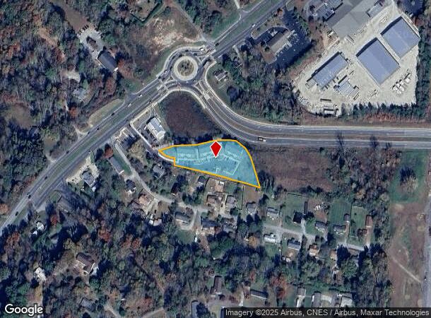
NEARBY LISTINGS FOR SALE OR LEASE
Property Detail
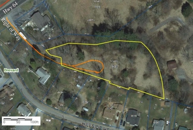
71 Maple Grove Ln
8597-23-9049-000
W W Roberts
Realpropertynec
TR-1 OFF HWY 64
X
Transylvania
3700859700J
North Carolina
2025
1.51 AC
2025
North Carolina West/Cherokee Area
960302
Other Market Areas
7,200 SF
Brevard, NC
DEMOGRAPHICS near 71 Maple Grove Ln
1 mile
3 mile
5 mile
2024 Total Population
1,168
9,083
16,672
2029 Population
1,190
9,250
16,952
Pop Growth 2024-2029
+ 1.88%
+ 1.84%
+ 1.68%
Average Age
45
45
45
2024 Total Households
472
3,907
7,147
HH Growth 2024-2029
+ 1.69%
+ 1.71%
+ 1.58%
Median Household Inc
$44,999
$55,973
$57,925
Avg Household Size
2.30
2.10
2.20
2024 Avg HH Vehicles
2.00
2.00
2.00
Median Home Value
$216,901
$270,761
$289,490
Median Year Built
1970
1976
1976
Nearby Places
Map Layers
Map Styles
 Street
 Aerial
Transit
 Traffic
 Biking
Places
Listings with unknown addresses are not visible on the map
- Restaurants
- Banks
- Shops
- Fitness
- Groceries
PUBLIC TRANSPORTATION
AIRPORT
Asheville Regional
Drive
Walk
Distance
Asheville Regional
25 min
16.6 mi
SALE & LEASE HISTORY
LISTING DATE
SALE/LEASE

Sep 24, 2016
For Sale
Jan 23, 2017
For Sale
Nearby Properties
Address
Land Use
TOTAL SIZE
Lot Size
Zoning
Address
Land Use
TOTAL SIZE
Lot Size
Zoning
13,072 SF
112.47 AC
R2
Address
Land Use
TOTAL SIZE
Lot Size
Zoning
25.70 AC
OI
Address
Land Use
TOTAL SIZE
Lot Size
Zoning
62,646 SF
10.02 AC
R1
Address
Land Use
TOTAL SIZE
Lot Size
Zoning
80,469 SF
14.60 AC
R2
Address
Land Use
TOTAL SIZE
Lot Size
Zoning
81,730 SF
17.59 AC
C2
Address
Land Use
TOTAL SIZE
Lot Size
Zoning
61,155 SF
11.06 AC
R1
Address
Land Use
TOTAL SIZE
Lot Size
Zoning
33,197 SF
5.90 AC
C2
Address
Land Use
TOTAL SIZE
Lot Size
Zoning
55,800 SF
1.02 AC
C1
Address
Land Use
TOTAL SIZE
Lot Size
Zoning
13,219 SF
149.63 AC
Address
Land Use
TOTAL SIZE
Lot Size
Zoning
51,024 SF
1.33 AC
C2
Address
Land Use
TOTAL SIZE
Lot Size
Zoning
82,770 SF
8.74 AC
C4
Address
Land Use
TOTAL SIZE
Lot Size
Zoning
11,000 SF
6.10 AC
C4
Address
Land Use
TOTAL SIZE
Lot Size
Zoning
37,298 SF
6.22 AC
C4
Address
Land Use
TOTAL SIZE
Lot Size
Zoning
8,850 SF
218.53 AC
Address
Land Use
TOTAL SIZE
Lot Size
Zoning
64,340 SF
3.80 AC
Address
Land Use
TOTAL SIZE
Lot Size
Zoning
1,713 SF
64.54 AC
Address
Land Use
TOTAL SIZE
Lot Size
Zoning
34,574 SF
7.46 AC
OI
Address
Land Use
TOTAL SIZE
Lot Size
Zoning
33,505 SF
2.70 AC
C2
Address
Land Use
TOTAL SIZE
Lot Size
Zoning
14,036 SF
6.58 AC
C4
Address
Land Use
TOTAL SIZE
Lot Size
Zoning
59,625 SF
6.94 AC
Address
Land Use
TOTAL SIZE
Lot Size
Zoning
39,812 SF
10.98 AC
Address
Land Use
TOTAL SIZE
Lot Size
Zoning
4,164 SF
2 AC
C4
Address
Land Use
TOTAL SIZE
Lot Size
Zoning
38,686 SF
4.16 AC
Address
Land Use
TOTAL SIZE
Lot Size
Zoning
1,760 SF
26.38 AC
OI
Address
Land Use
TOTAL SIZE
Lot Size
Zoning
19,820 SF
165 AC
C1
Address
Land Use
TOTAL SIZE
Lot Size
Zoning
49,569 SF
6.22 AC
The World's #1 Commercial Real Estate Marketplace
Connect with us
© 2026 CoStar Group
The information above has been obtained from sources believed reliable. While we do not doubt its accuracy we have not verified it and make no guarantee, warranty or representation about it. It is your responsibility to independently confirm its accuracy and completeness. Any projections, opinions, assumptions, or estimates used are for example only and do not represent the current or future performance of the property. The value of this transaction to you depends on tax and other factors which should be evaluated by your tax, financial, and legal advisors. You and your advisors should conduct a careful, independent investigation of the property to determine to your satisfaction the suitability of the property for your needs.