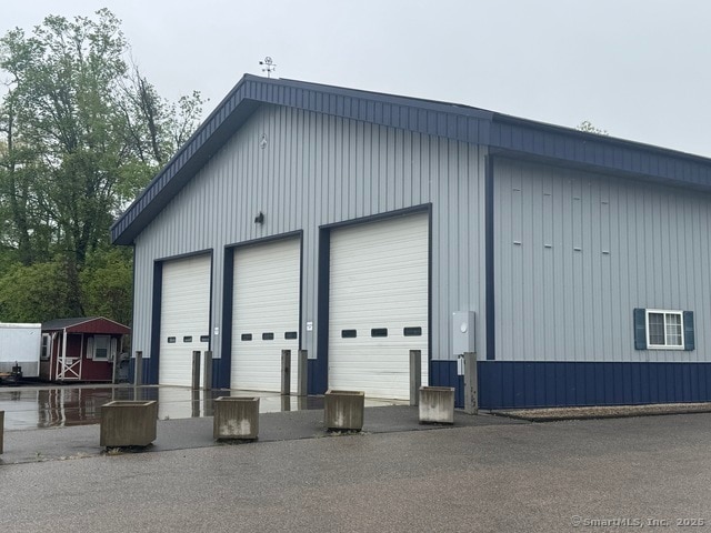
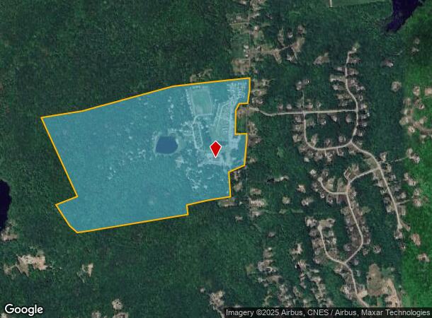
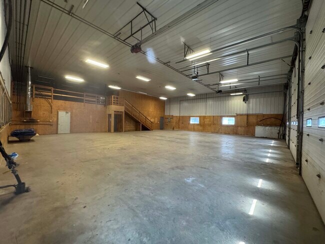
Property Record
71 Mott Hill Rd, East Hampton, CT 06424
NEARBY LISTINGS FOR SALE OR LEASE
-
-
View all East Hampton listings for lease on LoopNet.com
Property Detail
71 Mott Hill Rd
EHAM-000024-000044-000015A
Middlesex
Industrialgeneral
Connecticut
X
15a
09007C0135G
483.45 AC
2025
E Hampton/E Haddam
2025
Hartford
550100
Hartford-West Hartford-East Hartford, CT
DEMOGRAPHICS near 71 Mott Hill Rd
1 Mile
3 Mile
5 Mile
2024 Total Population
1,403
10,241
23,486
2029 Population
1,465
10,680
24,205
Pop Growth 2024-2029
+ 4.42%
+ 4.29%
+ 3.06%
Average Age
42
44
43
2024 Total Households
550
4,263
9,217
HH Growth 2024-2029
+ 4.55%
+ 4.41%
+ 3.19%
Median Household Inc
$117,424
$109,051
$120,271
Avg Household Size
2.50
2.40
2.50
2024 Avg HH Vehicles
2.00
2.00
2.00
Median Home Value
$306,757
$288,414
$323,843
Median Year Built
1979
1974
1976
Nearby Places
Map Layers
Map Styles
 Street
 Aerial
- Restaurants
- Banks
- Shops
- Fitness
- Groceries
PUBLIC TRANSPORTATION
AIRPORT
Bradley International
DRIVE
WALK
Distance
Bradley International
62 min
34.5 mi
Freight Ports
Port of New Haven
DRIVE
WALK
Distance
Port of New Haven
55 min
39.2 mi
SALE & LEASE HISTORY
LISTING DATE
SALE/LEASE

May 21, 2025
For Lease
Nearby Properties
Address
Land Use
TOTAL SIZE
Lot Size
Zoning
Address
Land Use
TOTAL SIZE
Lot Size
Zoning
127,409 SF
46.70 AC
R-1S
Address
Land Use
TOTAL SIZE
Lot Size
Zoning
75,272 SF
24.50 AC
R-2S
Address
Land Use
TOTAL SIZE
Lot Size
Zoning
11.13 AC
C
Address
Land Use
TOTAL SIZE
Lot Size
Zoning
2.98 AC
C
Address
Land Use
TOTAL SIZE
Lot Size
Zoning
36,865 SF
6.76 AC
R-1S
Address
Land Use
TOTAL SIZE
Lot Size
Zoning
17,000 SF
3.98 AC
R-2S
Address
Land Use
TOTAL SIZE
Lot Size
Zoning
10.53 AC
R-2S
Address
Land Use
TOTAL SIZE
Lot Size
Zoning
19,210 SF
1.85 AC
C
Address
Land Use
TOTAL SIZE
Lot Size
Zoning
39,482 SF
2.54 AC
I
Address
Land Use
TOTAL SIZE
Lot Size
Zoning
18,345 SF
5.40 AC
C
Address
Land Use
TOTAL SIZE
Lot Size
Zoning
16,270 SF
3.01 AC
VC
Address
Land Use
TOTAL SIZE
Lot Size
Zoning
2.96 AC
PO/R
Address
Land Use
TOTAL SIZE
Lot Size
Zoning
Address
Land Use
TOTAL SIZE
Lot Size
Zoning
1.70 AC
C
Address
Land Use
TOTAL SIZE
Lot Size
Zoning
Address
Land Use
TOTAL SIZE
Lot Size
Zoning
4.96 AC
R-2S
Address
Land Use
TOTAL SIZE
Lot Size
Zoning
36.02 AC
R
Address
Land Use
TOTAL SIZE
Lot Size
Zoning
17,472 SF
0.66 AC
DD
Address
Land Use
TOTAL SIZE
Lot Size
Zoning
17,472 SF
0.65 AC
DD
Address
Land Use
TOTAL SIZE
Lot Size
Zoning
17,000 SF
5.28 AC
DD
Address
Land Use
TOTAL SIZE
Lot Size
Zoning
4,968 SF
0.72 AC
C
Address
Land Use
TOTAL SIZE
Lot Size
Zoning
14,580 SF
0.40 AC
R-1S
Address
Land Use
TOTAL SIZE
Lot Size
Zoning
10,593 SF
2.84 AC
C
Address
Land Use
TOTAL SIZE
Lot Size
Zoning
0.84 AC
C
Address
Land Use
TOTAL SIZE
Lot Size
Zoning
5 AC
R-1S
Address
Land Use
TOTAL SIZE
Lot Size
Zoning
0.38 AC
VC
Address
Land Use
TOTAL SIZE
Lot Size
Zoning
167 AC
VC
Address
Land Use
TOTAL SIZE
Lot Size
Zoning
15.47 AC
C
Address
Land Use
TOTAL SIZE
Lot Size
Zoning
8,860 SF
0.69 AC
VC
The World's #1 Commercial Real Estate Marketplace
Connect with us
© 2026 CoStar Group
The information above has been obtained from sources believed reliable. While we do not doubt its accuracy we have not verified it and make no guarantee, warranty or representation about it. It is your responsibility to independently confirm its accuracy and completeness. Any projections, opinions, assumptions, or estimates used are for example only and do not represent the current or future performance of the property. The value of this transaction to you depends on tax and other factors which should be evaluated by your tax, financial, and legal advisors. You and your advisors should conduct a careful, independent investigation of the property to determine to your satisfaction the suitability of the property for your needs.